TopoQuest Logo
Do you find TopoQuest useful?
Help keep TopoQuest running and adding new maps/features by donating!
Bitcoin:  19c7KJd3qBynnjoSw5npx9KScwjBe4ifkT
Litecoin:  LXs6TkuXGGXo1vDsWCkWVdjQX94eUKd6ui
Home View Maps Find Maps Find Places Resources & Links


Brookfield, Missouri Topographic Map

USGS Map Title: Brookfield, MO
USGS Map MRC: 39093G1
DRG (GeoTIFF) Download: o39093g1.tif


Neighboring USGS Topographic Map Quads:


  Linneus, MO  
39093H2
 

  Shelby, MO  
39093H1
 

  Bucklin NW, MO  
39092H8
 

  Laclede, MO  
39093G2
 

  Brookfield, MO  
39093G1
 

  Bucklin, MO  
39092G8
 

  Sumner, MO  
39093F2
 

  Rothville, MO  
39093F1
 

  Marceline, MO  
39092F8


Map MRC Location:

N40°
W94°
N40°
W93°
H8 H7 H6 H5 H4 H3 H2 H1
G8 G7 G6 G5 G4 G3 G2 G1
F8 F7 F6 F5 F4 F3 F2 F1
E8 E7 E6 E5 E4 E3 E2 E1
D8 D7 D6 D5 D4 D3 D2 D1
C8 C7 C6 C5 C4 C3 C2 C1
B8 B7 B6 B5 B4 B3 B2 B1
A8 A7 A6 A5 A4 A3 A2 A1
N39°
W94°
N39°
W93°

Brookfield, MO USGS 1:24K Topographic Map Preview:
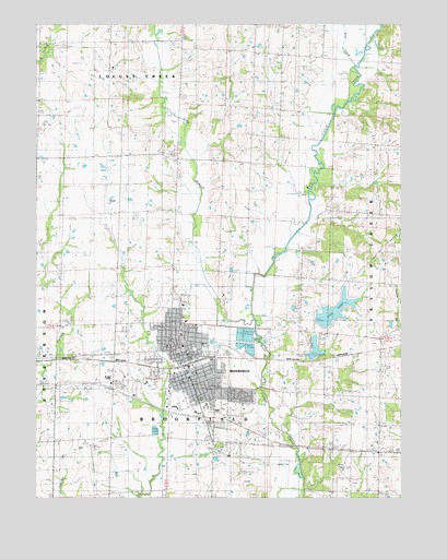
Brookfield, MO USGS Topographic Map
Click on map above to begin viewing in our Map Viewer.

This topographic map contains these locations and features:
Feature Name Type Latitude Longitude GNIS ID View Map
Bear CreekStreamN39.8639°W93.0166°713808View Map
BrookfieldPopulated PlaceN39.7845°W93.0735°735530View Map
Brookfield City DamDamN39.7967°W93.0285°760482View Map
Brookfield Country Club DamDamN39.7884°W93.0319°760488View Map
Brookfield Country Club LakeReservoirN39.7895°W93.0297°760489View Map
Brookfield LakeReservoirN39.8472°W93.0280°735959View Map
Brookfield PlazaLocaleN39.7720°W93.0688°736106View Map
Brookfield Police DepartmentBuildingN39.7867°W93.0755°2752491View Map
Brookfield Post OfficePost OfficeN39.7852°W93.0756°2782818View Map
Brookfield ReservoirReservoirN39.7917°W93.0519°760487View Map
Brookfield Reservoir DamDamN39.7917°W93.0519°760486View Map
Brookfield Rural Fire DepartmentBuildingN39.7866°W93.0758°2621175View Map
Brookfield Volunteer Fire DepartmentBuildingN39.7867°W93.0758°2621437View Map
Bruner SchoolSchoolN39.8161°W93.1241°714815View Map
Burch SchoolSchoolN39.8245°W93.0919°715063View Map
Carey SchoolSchoolN39.8045°W93.0335°715394View Map
City LakeReservoirN39.7976°W93.0263°738439View Map
City of BrookfieldCivilN39.7853°W93.0772°2393426View Map
Crescent SchoolSchoolN39.7645°W93.0077°716489View Map
General John J Pershing Memorial AirportAirportN39.7611°W93.1044°758603View Map
General John J Pershing Memorial HospitalHospitalN39.7746°W93.0669°1992883View Map
General John J Pershing Memorial Hospital HeliportAirportN39.7750°W93.0674°758601View Map
KGNG-AM (Brookfield)TowerN39.8406°W93.0813°754302View Map
KZBK-FM (Brookfield)TowerN39.8406°W93.0810°759093View Map
Linheart ChurchChurchN39.8425°W93.0094°721113View Map
Linn Center SchoolSchoolN39.8697°W93.0983°721125View Map
Linn CountyCivilN39.8702°W93.1072°758512View Map
Long BranchStreamN39.7970°W93.0505°721515View Map
McClure School (historical)SchoolN39.8245°W93.0516°722049View Map
Moore School (historical)SchoolN39.7770°W93.0363°722587View Map
New Garden CemeteryCemeteryN39.8531°W93.0455°723203View Map
New Garden ChurchChurchN39.8509°W93.0513°723205View Map
North Central Missouri Regional AirportAirportN39.7673°W93.0144°1992867View Map
Prairie Flower SchoolSchoolN39.8681°W93.0541°724842View Map
Rosehill CemeteryCemeteryN39.7695°W93.0660°1802778View Map
Township of BrookfieldCivilN39.7724°W93.0724°766914View Map
Troutman Airport (historical)AirportN39.7500°W93.0502°758602View Map

Note: Coordinates in the location and feature list above are referenced to NAD83 datum.


Copyright (C) 2008-2024 Ryan Niemi / Sunset Dynamics ... All Rights Reserved