TopoQuest Logo
Do you find TopoQuest useful?
Help keep TopoQuest running and adding new maps/features by donating!
Bitcoin:  19c7KJd3qBynnjoSw5npx9KScwjBe4ifkT
Litecoin:  LXs6TkuXGGXo1vDsWCkWVdjQX94eUKd6ui
Home View Maps Find Maps Find Places Resources & Links


New Boston, Missouri Topographic Map

USGS Map Title: New Boston, MO
USGS Map MRC: 39092H7
DRG (GeoTIFF) Download: o39092h7.tif


Neighboring USGS Topographic Map Quads:


  Winigan, MO  
40092A8
 

  Nind, MO  
40092A7
 

  Gifford, MO  
40092A6
 

  Bucklin NW, MO  
39092H8
 

  New Boston, MO  
39092H7
 

  Elmer, MO  
39092H6
 

  Bucklin, MO  
39092G8
 

  New Cambria West, MO  
39092G7
 

  New Cambria East, MO  
39092G6


Map MRC Location:

N40°
W93°
N40°
W92°
H8 H7 H6 H5 H4 H3 H2 H1
G8 G7 G6 G5 G4 G3 G2 G1
F8 F7 F6 F5 F4 F3 F2 F1
E8 E7 E6 E5 E4 E3 E2 E1
D8 D7 D6 D5 D4 D3 D2 D1
C8 C7 C6 C5 C4 C3 C2 C1
B8 B7 B6 B5 B4 B3 B2 B1
A8 A7 A6 A5 A4 A3 A2 A1
N39°
W93°
N39°
W92°

New Boston, MO USGS 1:24K Topographic Map Preview:
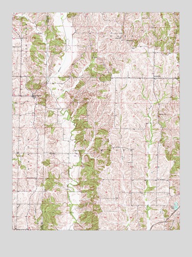
New Boston, MO USGS Topographic Map
Click on map above to begin viewing in our Map Viewer.

This topographic map contains these locations and features:
Feature Name Type Latitude Longitude GNIS ID View Map
Advent SchoolSchoolN39.9839°W92.7899°713165View Map
Badger CreekStreamN39.9606°W92.8477°713527View Map
Bell CemeteryCemeteryN39.9039°W92.7619°713904View Map
BensonPopulated PlaceN39.8975°W92.8585°740198View Map
Brush Creek School (historical)SchoolN39.8964°W92.7733°733704View Map
Ethel LakeReservoirN39.8888°W92.7532°758279View Map
Ethel Lake DamDamN39.8867°W92.7519°760280View Map
Fairview SchoolSchoolN39.9414°W92.7658°717816View Map
GoldsberryPopulated PlaceN39.9623°W92.7694°718547View Map
Green SchoolSchoolN39.9189°W92.8430°718810View Map
Helton ChurchChurchN39.9856°W92.7941°719359View Map
Maple Grove ChurchChurchN39.9809°W92.8671°721823View Map
Nagel School (historical)SchoolN39.9809°W92.8169°733702View Map
New BostonPopulated PlaceN39.9520°W92.8596°723188View Map
New Boston Post OfficePost OfficeN39.9517°W92.8596°2782717View Map
New Boston SchoolSchoolN39.9539°W92.8577°733984View Map
New Boston Volunteer Fire DepartmentBuildingN39.9513°W92.8596°2620733View Map
North Swede ChurchChurchN39.9053°W92.8571°723501View Map
Oak Ridge Farms AirportAirportN39.9826°W92.8664°2679373View Map
Oak Ridge School (historical)SchoolN39.9481°W92.8185°733703View Map
People School (historical)SchoolN39.8931°W92.8099°733705View Map
Township of WhiteCivilN39.9188°W92.7948°766981View Map
Union ChapelChurchN39.9200°W92.8246°727979View Map
White CemeteryCemeteryN39.9139°W92.7896°728723View Map

Note: Coordinates in the location and feature list above are referenced to NAD83 datum.


Copyright (C) 2008-2025 Ryan Niemi / Sunset Dynamics ... All Rights Reserved