TopoQuest Logo
Do you find TopoQuest useful?
Help keep TopoQuest running and adding new maps/features by donating!
Bitcoin:  19c7KJd3qBynnjoSw5npx9KScwjBe4ifkT
Litecoin:  LXs6TkuXGGXo1vDsWCkWVdjQX94eUKd6ui
Home View Maps Find Maps Find Places Resources & Links


Bucks Nest, Montana Topographic Map

USGS Map Title: Bucks Nest, MT
USGS Map MRC: 45111A6
DRG (GeoTIFF) Download: o45111a6.tif


Neighboring USGS Topographic Map Quads:


  Varney, MT  
45111B7
 

  Cameron, MT  
45111B6
 

  Lake Cameron, MT  
45111B5
 

  Broomtail Ridge, MT  
45111A7
 

  Bucks Nest, MT  
45111A6
 

  No Man Peak, MT  
45111A5
 

  Big Horn Mountain, MT  
44111H7
 

  Granite Mountain, MT  
44111H6
 

  Bad Luck Creek, MT  
44111H5


Map MRC Location:

N46°
W112°
N46°
W111°
H8 H7 H6 H5 H4 H3 H2 H1
G8 G7 G6 G5 G4 G3 G2 G1
F8 F7 F6 F5 F4 F3 F2 F1
E8 E7 E6 E5 E4 E3 E2 E1
D8 D7 D6 D5 D4 D3 D2 D1
C8 C7 C6 C5 C4 C3 C2 C1
B8 B7 B6 B5 B4 B3 B2 B1
A8 A7 A6 A5 A4 A3 A2 A1
N45°
W112°
N45°
W111°

Bucks Nest, MT USGS 1:24K Topographic Map Preview:
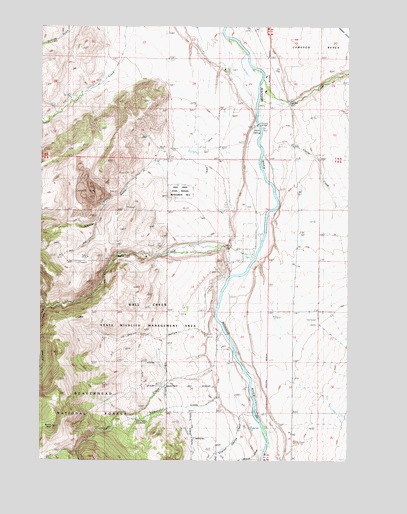
Bucks Nest, MT USGS Topographic Map
Click on map above to begin viewing in our Map Viewer.

This topographic map contains these locations and features:
Feature Name Type Latitude Longitude GNIS ID View Map
08S01W25BBC_01 WellWellN45.1130°W111.6783°807973View Map
08S01W34DDDB01 WellWellN45.0880°W111.7002°807839View Map
09S01E07CBAC01 WellWellN45.0633°W111.6552°807631View Map
09S01E31BCAB01 WellWellN45.0096°W111.6550°807305View Map
09S01W01DBBA01 WellWellN45.0785°W111.6666°807769View Map
09S01W12DCAD01 WellWellN45.0599°W111.6641°807606View Map
Abe (historical)Populated PlaceN45.0433°W111.6841°1797588View Map
Abe Post Office (historical)Post OfficeN45.0433°W111.6841°1797587View Map
Abe School (historical)SchoolN45.0433°W111.6841°1797589View Map
Bobcat CreekStreamN45.0033°W111.6600°780183View Map
Bucks NestSummitN45.0099°W111.7464°780529View Map
Corral CreekStreamN45.0949°W111.6608°781694View Map
Cyprus MineMineN45.0771°W111.7316°794518View Map
Dry Fork TrailTrailN45.0291°W111.7344°782608View Map
Dry HollowValleyN45.0363°W111.6827°782644View Map
English George CreekStreamN45.0135°W111.6641°783210View Map
Horse Creek DitchCanalN45.0088°W111.6919°785042View Map
Hyde CreekStreamN45.0338°W111.6733°785196View Map
Hyde Creek DitchCanalN45.0116°W111.6922°785198View Map
Indian CreekStreamN45.1099°W111.6602°785250View Map
Johny GulchValleyN45.0896°W111.6975°785553View Map
Krauss SawmillLocaleN45.0446°W111.7419°785850View Map
Lichte RanchLocaleN45.0349°W111.6983°786094View Map
Lichte Ruby Creek DitchCanalN45.0555°W111.7219°786095View Map
McAtee BridgeBridgeN45.0971°W111.6627°786981View Map
McAtee Bridge Sportsmans AccessLocaleN45.0983°W111.6766°801852View Map
Mountain Talc MineMineN45.0749°W111.7297°787761View Map
Nickerson CreekStreamN45.0188°W111.6775°787995View Map
Olsen DitchCanalN45.0866°W111.6855°788447View Map
Olsen RanchLocaleN45.1130°W111.6752°788446View Map
Ruby CreekStreamN45.0591°W111.6639°793907View Map
Ruby MineMineN45.0585°W111.7322°789836View Map
South Fork Hyde CreekStreamN45.0035°W111.7361°790985View Map
South Fork Ruby CreekStreamN45.0444°W111.7483°791041View Map
Wall Creek Forest Service StationLocaleN45.0110°W111.7075°806821View Map
Wall Creek State Wildlife Management AreaParkN45.0241°W111.6850°807064View Map
West Madison Recreation AreaLocaleN45.0599°W111.6644°801857View Map

Note: Coordinates in the location and feature list above are referenced to NAD83 datum.


Copyright (C) 2008-2024 Ryan Niemi / Sunset Dynamics ... All Rights Reserved