TopoQuest Logo
Do you find TopoQuest useful?
Help keep TopoQuest running and adding new maps/features by donating!
Bitcoin:  19c7KJd3qBynnjoSw5npx9KScwjBe4ifkT
Litecoin:  LXs6TkuXGGXo1vDsWCkWVdjQX94eUKd6ui
Home View Maps Find Maps Find Places Resources & Links


Buffalo Springs, Virginia Topographic Map

USGS Map Title: Buffalo Springs, VA
USGS Map MRC: 36078F6
DRG (GeoTIFF) Download: o36078f6.tif


Neighboring USGS Topographic Map Quads:


  Scottsburg, VA  
36078G7
 

  Clover, VA  
36078G6
 

  Wylliesburg, VA  
36078G5
 

  Omega, VA  
36078F7
 

  Buffalo Springs, VA  
36078F6
 

  Clarksville North, VA  
36078F5
 

  Virgilina, VA  
36078E7
 

  Nelson, VA  
36078E6
 

  Clarksville South, VA  
36078E5


Map MRC Location:

N37°
W79°
N37°
W78°
H8 H7 H6 H5 H4 H3 H2 H1
G8 G7 G6 G5 G4 G3 G2 G1
F8 F7 F6 F5 F4 F3 F2 F1
E8 E7 E6 E5 E4 E3 E2 E1
D8 D7 D6 D5 D4 D3 D2 D1
C8 C7 C6 C5 C4 C3 C2 C1
B8 B7 B6 B5 B4 B3 B2 B1
A8 A7 A6 A5 A4 A3 A2 A1
N36°
W79°
N36°
W78°

Buffalo Springs, VA USGS 1:24K Topographic Map Preview:
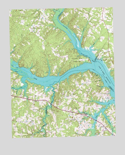
Buffalo Springs, VA USGS Topographic Map
Click on map above to begin viewing in our Map Viewer.

This topographic map contains these locations and features:
Feature Name Type Latitude Longitude GNIS ID View Map
Aaron Penston FieldAirportN36.6620°W78.7225°1498817View Map
Aarons CreekPopulated PlaceN36.6613°W78.7219°1492444View Map
Aarons CreekStreamN36.6746°W78.7011°1023788View Map
Aarons Creek Baptist ChurchChurchN36.6576°W78.7233°1496657View Map
Aarons Creek CemeteryCemeteryN36.6587°W78.7217°1690095View Map
Abbeville Mill (historical)LocaleN36.7024°W78.6469°1500879View Map
Bagbys Ferry (historical)CrossingN36.6796°W78.7086°1496660View Map
Big Level ChurchChurchN36.7207°W78.6300°1500615View Map
Big River Ranch Airport (historical)AirportN36.6751°W78.6950°1498632View Map
Blanks CemeteryCemeteryN36.6471°W78.6769°1500618View Map
Bowen CemeteryCemeteryN36.6257°W78.6908°1500625View Map
Buffalo Baptist TabernacleChurchN36.6460°W78.6631°1500630View Map
Buffalo CemeteryCemeteryN36.6274°W78.6467°1500631View Map
Buffalo ChurchChurchN36.6274°W78.6475°1464029View Map
Buffalo Public Use AreaParkN36.6621°W78.6311°1464047View Map
Buffalo SpringsPopulated PlaceN36.6460°W78.6617°1492670View Map
Buffalo Springs School (historical)SchoolN36.6549°W78.6614°1500632View Map
Buffalo Tabernacle CemeteryCemeteryN36.6457°W78.6631°1500633View Map
Buffalo Wildlife Management AreaParkN36.6760°W78.6447°1500634View Map
Cargills CreekStreamN36.7165°W78.6647°1464441View Map
Cargills Creek Wildlife Management AreaParkN36.7279°W78.6606°1500880View Map
Carters PointPopulated PlaceN36.6590°W78.6333°1500642View Map
Cherry BranchStreamN36.6976°W78.7411°1500885View Map
Cherry Hill ChurchChurchN36.6343°W78.6389°1464778View Map
Clays QuarryMineN36.7143°W78.6639°1500881View Map
Difficult CreekStreamN36.7451°W78.6878°1465787View Map
DryburgPopulated PlaceN36.7312°W78.7217°1477277View Map
Dyer CemeteryCemeteryN36.6399°W78.7258°1496691View Map
Eastern Pines DamDamN36.7318°W78.6664°1489434View Map
Elliot BranchStreamN36.6796°W78.6392°1466245View Map
Fairview AcresPopulated PlaceN36.7057°W78.6419°1500690View Map
Flat BranchStreamN36.6729°W78.7408°1466641View Map
Flat Rock BranchStreamN36.6432°W78.6503°1466655View Map
Fleming CornerPopulated PlaceN36.7038°W78.6906°1496698View Map
Gravel Hill CemeteryCemeteryN36.6657°W78.6758°1500706View Map
Gravel Hill ChurchChurchN36.6660°W78.6756°1467381View Map
Gravel Hill School (historical)SchoolN36.6632°W78.6808°1500707View Map
High HillPopulated PlaceN36.6360°W78.7492°1493082View Map
Hog Island (historical)IslandN36.6849°W78.6850°1496718View Map
Hogan CreekStreamN36.7079°W78.6522°1468116View Map
Hogan Creek Wildlife Management AreaParkN36.7113°W78.6492°1500882View Map
Hyco Falls (historical)FallsN36.6846°W78.7283°1500888View Map
Hyco RiverStreamN36.6838°W78.7319°987307View Map
Jamison BranchStreamN36.6251°W78.6533°1468637View Map
Jeffreys Chute (historical)ChannelN36.6935°W78.6481°1500893View Map
LaconiaPopulated PlaceN36.7374°W78.6364°1492400View Map
Line BranchStreamN36.6849°W78.7044°1500891View Map
Little Buffalo CreekStreamN36.6490°W78.6394°1469487View Map
Lower Banks CreekStreamN36.6843°W78.6922°1500892View Map
Marble Yard Shoals (historical)BarN36.6893°W78.6669°1496726View Map
MidwayPopulated PlaceN36.6410°W78.7261°1477539View Map
Midway Volunteer Fire DepartmentBuildingN36.6626°W78.7247°2075369View Map
Millstone BranchStreamN36.6738°W78.6367°1470583View Map
Morris BranchStreamN36.6788°W78.7319°1470753View Map
Nelsons Island (historical)IslandN36.6793°W78.6319°1500894View Map
North ForkStreamN36.6335°W78.7119°1471595View Map
Number Three BranchStreamN36.6451°W78.6531°1471686View Map
Oak Level School (historical)SchoolN36.6260°W78.6908°1500771View Map
Peter CreekStreamN36.6849°W78.7244°1472221View Map
Pools MillPopulated PlaceN36.6565°W78.7031°1496750View Map
Saint Marks ChurchChurchN36.6640°W78.6806°1473816View Map
Saint Marks School (historical)SchoolN36.6643°W78.6808°1500810View Map
Saw Mill BranchStreamN36.6910°W78.7269°1500898View Map
Snead CemeteryCemeteryN36.6407°W78.7378°1496756View Map
Spanish Grove ChurchChurchN36.7337°W78.7292°1474929View Map
Staunton River State ParkParkN36.6993°W78.6681°1475101View Map
Staunton View Public Use AreaParkN36.7007°W78.6422°1475103View Map
Tanyard BranchStreamN36.6318°W78.6519°1475466View Map
Tomtit BranchStreamN36.6851°W78.6436°1475781View Map
Walker BranchStreamN36.6563°W78.6342°1476231View Map
White Oak Fork CemeteryCemeteryN36.6404°W78.7339°1496770View Map

Note: Coordinates in the location and feature list above are referenced to NAD83 datum.


Copyright (C) 2008-2025 Ryan Niemi / Sunset Dynamics ... All Rights Reserved