TopoQuest Logo
Do you find TopoQuest useful?
Help keep TopoQuest running and adding new maps/features by donating!
Bitcoin:  19c7KJd3qBynnjoSw5npx9KScwjBe4ifkT
Litecoin:  LXs6TkuXGGXo1vDsWCkWVdjQX94eUKd6ui
Home View Maps Find Maps Find Places Resources & Links


Clarksville North, Virginia Topographic Map

USGS Map Title: Clarksville North, VA
USGS Map MRC: 36078F5
DRG (GeoTIFF) Download: o36078f5.tif


Neighboring USGS Topographic Map Quads:


  Clover, VA  
36078G6
 

  Wylliesburg, VA  
36078G5
 

  Chase City, VA  
36078G4
 

  Buffalo Springs, VA  
36078F6
 

  Clarksville North, VA  
36078F5
 

  Boydton, VA  
36078F4
 

  Nelson, VA  
36078E6
 

  Clarksville South, VA  
36078E5
 

  Tungsten, NC  
36078E4


Map MRC Location:

N37°
W79°
N37°
W78°
H8 H7 H6 H5 H4 H3 H2 H1
G8 G7 G6 G5 G4 G3 G2 G1
F8 F7 F6 F5 F4 F3 F2 F1
E8 E7 E6 E5 E4 E3 E2 E1
D8 D7 D6 D5 D4 D3 D2 D1
C8 C7 C6 C5 C4 C3 C2 C1
B8 B7 B6 B5 B4 B3 B2 B1
A8 A7 A6 A5 A4 A3 A2 A1
N36°
W79°
N36°
W78°

Clarksville North, VA USGS 1:24K Topographic Map Preview:
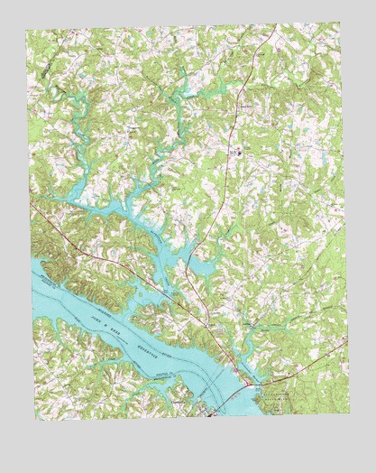
Clarksville North, VA USGS Topographic Map
Click on map above to begin viewing in our Map Viewer.

This topographic map contains these locations and features:
Feature Name Type Latitude Longitude GNIS ID View Map
BluestonePopulated PlaceN36.7126°W78.6061°1500620View Map
Bluestone CemeteryCemeteryN36.6535°W78.5547°1500621View Map
Bluestone ChurchChurchN36.6535°W78.5550°1463599View Map
Bluestone CreekStreamN36.6576°W78.5883°1463601View Map
Bluestone LandingLocaleN36.6643°W78.5703°1492599View Map
Bluestone Middle SchoolSchoolN36.7089°W78.5409°2499248View Map
Bluestone School (historical)SchoolN36.7088°W78.6167°1500622View Map
Bluestone Wildlife Management AreaParkN36.6660°W78.5936°1500623View Map
Buffalo CreekStreamN36.6596°W78.6225°1464041View Map
Burwell CemeteryCemeteryN36.6393°W78.5956°1500635View Map
Cedar Grove ChurchChurchN36.6985°W78.5683°1464613View Map
Clarksville OverlookLocaleN36.6343°W78.5386°1500661View Map
Clarksville Post OfficePost OfficeN36.6252°W78.5573°2766177View Map
Crowders BranchStreamN36.6960°W78.6097°1500672View Map
Dan RiverStreamN36.6560°W78.5986°1465581View Map
District 8CivilN36.7452°W78.5013°1927291View Map
District 9CivilN36.6373°W78.6092°1927294View Map
Dortch StorePopulated PlaceN36.6582°W78.5547°1500675View Map
Ephesus CemeteryCemeteryN36.7171°W78.5858°1500688View Map
Ephesus ChurchChurchN36.7168°W78.5850°1466325View Map
Finchley School (historical)SchoolN36.6507°W78.5011°1500696View Map
Goodell CreekStreamN36.6738°W78.5536°1467221View Map
Hanford CrossroadsPopulated PlaceN36.7479°W78.5264°1500711View Map
Hollow Rock School (historical)SchoolN36.7096°W78.5053°1500718View Map
Irish CreekStreamN36.6446°W78.5886°1468513View Map
JeffressPopulated PlaceN36.6538°W78.5369°1477445View Map
Jones StoreLocaleN36.7235°W78.5406°1468862View Map
Lake Country Christian AcademySchoolN36.6252°W78.5562°2499236View Map
Little Bluestone CreekStreamN36.6913°W78.5853°1469477View Map
Moore School (historical)SchoolN36.6965°W78.5725°1500753View Map
Mooresville EstatesPopulated PlaceN36.6829°W78.5789°1500754View Map
Mooresville School (historical)SchoolN36.6576°W78.5558°1500755View Map
Morgans DamDamN36.6535°W78.5497°1490400View Map
New Light ChurchChurchN36.7401°W78.5333°1471464View Map
Oak HillsPopulated PlaceN36.6749°W78.6117°1500770View Map
Oakley School (historical)SchoolN36.7026°W78.5467°1500774View Map
Occoneechee HarborBayN36.6382°W78.5383°1471806View Map
Occoneechee Island (historical)IslandN36.6482°W78.5839°1500895View Map
Occoneechee State ParkParkN36.6276°W78.5278°1471807View Map
OrgainvillePopulated PlaceN36.7176°W78.5847°1477596View Map
Owens CreekStreamN36.6376°W78.5706°1471996View Map
Peckerwood BranchStreamN36.7288°W78.5472°1472165View Map
Perfect PointPopulated PlaceN36.6349°W78.5664°1500782View Map
Persimmon Tree BranchStreamN36.7246°W78.5642°1472219View Map
Phillip Saint Julian Wilson BridgeBridgeN36.6307°W78.5478°1500783View Map
Popes CreekStreamN36.6890°W78.5236°1472628View Map
Prestwood PlantationLocaleN36.6499°W78.5642°1500791View Map
PrestwouldPopulated PlaceN36.6532°W78.5664°1500789View Map
Reedy BranchStreamN36.6890°W78.5236°1473101View Map
Ridge School (historical)SchoolN36.7499°W78.5850°1500801View Map
Rocky BranchStreamN36.7293°W78.5639°1473440View Map
Saint Johns ChurchChurchN36.6357°W78.6133°1473754View Map
Saint Johns School (historical)SchoolN36.6354°W78.6136°1500808View Map
Saint Lukes ChurchChurchN36.6913°W78.5050°1473798View Map
Saint Matthews CemeteryCemeteryN36.6624°W78.5456°1473842View Map
Saint Matthews ChurchChurchN36.6579°W78.5542°1473844View Map
Saint Matthews School (historical)SchoolN36.6593°W78.5528°1500811View Map
Sandy CreekStreamN36.6440°W78.5408°1474011View Map
Skipwiths Ferry (historical)CrossingN36.6399°W78.5675°1500820View Map
West End High SchoolSchoolN36.7090°W78.5408°1476478View Map
Willis DamDamN36.7051°W78.5081°1490397View Map
Willis PondReservoirN36.7065°W78.5074°1490398View Map
WLCQ-FM (Clarksville)TowerN36.6460°W78.5083°1498976View Map

Note: Coordinates in the location and feature list above are referenced to NAD83 datum.


Copyright (C) 2008-2024 Ryan Niemi / Sunset Dynamics ... All Rights Reserved