TopoQuest Logo
Do you find TopoQuest useful?
Help keep TopoQuest running and adding new maps/features by donating!
Bitcoin:  19c7KJd3qBynnjoSw5npx9KScwjBe4ifkT
Litecoin:  LXs6TkuXGGXo1vDsWCkWVdjQX94eUKd6ui
Home View Maps Find Maps Find Places Resources & Links


Clairmont Springs, Alabama Topographic Map

USGS Map Title: Clairmont Springs, AL
USGS Map MRC: 33085C8
DRG (GeoTIFF) Download: o33085c8.tif


Neighboring USGS Topographic Map Quads:


  Talladega, AL  
33086D1
 

  Ironaton, AL  
33085D8
 

  Cheaha Mountain, AL  
33085D7
 

  Porter Gap, AL  
33086C1
 

  Clairmont Springs, AL  
33085C8
 

  Lineville West, AL  
33085C7
 

  Bulls Gap, AL  
33086B1
 

  Millerville, AL  
33085B8
 

  Gibsonville, AL  
33085B7


Map MRC Location:

N34°
W86°
N34°
W85°
H8 H7 H6 H5 H4 H3 H2 H1
G8 G7 G6 G5 G4 G3 G2 G1
F8 F7 F6 F5 F4 F3 F2 F1
E8 E7 E6 E5 E4 E3 E2 E1
D8 D7 D6 D5 D4 D3 D2 D1
C8 C7 C6 C5 C4 C3 C2 C1
B8 B7 B6 B5 B4 B3 B2 B1
A8 A7 A6 A5 A4 A3 A2 A1
N33°
W86°
N33°
W85°

Clairmont Springs, AL USGS 1:24K Topographic Map Preview:
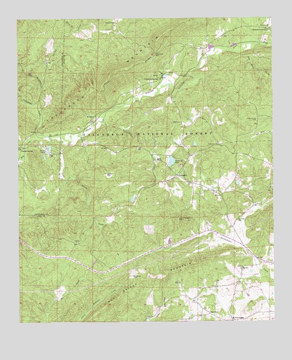
Clairmont Springs, AL USGS Topographic Map
Click on map above to begin viewing in our Map Viewer.

This topographic map contains these locations and features:
Feature Name Type Latitude Longitude GNIS ID View Map
Acme MineMineN33.2937°W85.8966°151099View Map
Alabama Graphic MineMineN33.2757°W85.9236°161983View Map
Alabama Number One MineMineN33.2748°W85.9252°163046View Map
Alabama Number Two MineMineN33.2787°W85.9452°151112View Map
Allen MineMineN33.2665°W85.9439°151114View Map
Antioch ChurchChurchN33.2859°W85.9722°159072View Map
Ashland MineMineN33.2793°W85.9055°151101View Map
Axton-Noe MineMineN33.2804°W85.9355°151111View Map
Blue CreekStreamN33.3382°W85.9905°159209View Map
Burgess CemeteryCemeteryN33.3579°W85.9814°162404View Map
Buzzard CreekStreamN33.3326°W85.9591°159287View Map
California ProspectMineN33.2890°W85.9044°151100View Map
Campbells CrossroadsPopulated PlaceN33.3701°W85.8766°159309View Map
Caten Shoals CreekStreamN33.3351°W85.9852°159335View Map
Chandler Spring Station (historical)LocaleN33.3287°W85.9916°162410View Map
Chandler SpringsPopulated PlaceN33.3307°W85.9983°159365View Map
Chickasaw Town (historical)LocaleN33.3626°W85.9916°162412View Map
Clairmont GapGapN33.3607°W85.9327°159409View Map
Clairmont SpringsPopulated PlaceN33.3504°W85.9302°159410View Map
Clairmont Springs CemeteryCemeteryN33.3565°W85.9269°1805376View Map
Clairmont Springs ChurchChurchN33.3568°W85.9264°151108View Map
Cole Bridge Church (historical)ChurchN33.2687°W85.9402°139661View Map
Crucible MineMineN33.2521°W85.9550°151117View Map
Crucible ProspectMineN33.3071°W85.8902°151096View Map
Eagle MineMineN33.2696°W85.9489°163053View Map
Eley MineMineN33.3454°W85.9000°151091View Map
Enitachopco (historical)LocaleN33.3034°W85.9036°162003View Map
Enitachopco MineMineN33.2873°W85.9136°163054View Map
Enterprise MineMineN33.3159°W85.9614°151109View Map
ErinPopulated PlaceN33.3626°W85.9086°159577View Map
Fairview ChurchChurchN33.3332°W85.8827°162004View Map
Friendship ChurchChurchN33.3568°W85.9269°169112View Map
Garing CreekStreamN33.3515°W85.9933°159653View Map
Gibson MineMineN33.3421°W85.8864°163057View Map
Gold Mines CreekStreamN33.3615°W85.8944°159678View Map
Graphite (historical)LocaleN33.2709°W85.9569°162011View Map
Griessemer MineMineN33.2743°W85.9089°151102View Map
GunthertownPopulated PlaceN33.3740°W85.9525°159040View Map
Haraldson MineMineN33.3379°W85.9150°151092View Map
Heflin School (historical)SchoolN33.3146°W85.9269°162014View Map
High PinePopulated PlaceN33.2534°W85.9064°159771View Map
High Pine Church (historical)ChurchN33.2521°W85.9111°151103View Map
Hobbs ProspectMineN33.3204°W85.9069°151097View Map
Horn BranchStreamN33.3704°W85.9722°159802View Map
Horne DamDamN33.3201°W85.9866°161377View Map
Hornes LakesReservoirN33.3216°W85.9850°159806View Map
Horns Peak MineMineN33.3148°W85.9155°151098View Map
Hudson MineMineN33.3468°W85.8883°163060View Map
Idaho (historical)LocaleN33.3173°W85.9341°162018View Map
Idaho MineMineN33.3162°W85.8994°151095View Map
Idaho Volunteer Fire DepartmentBuildingN33.3167°W85.9309°2683189View Map
Ironston GapGapN33.3596°W85.9347°162020View Map
Jackson MineMineN33.3204°W85.9297°163062View Map
Jefferson MineMineN33.2621°W85.9408°151115View Map
Kants Mill (historical)LocaleN33.3476°W85.9880°162465View Map
Lee Number One MineMineN33.3440°W85.8847°163065View Map
Lee Number Two MineMineN33.3479°W85.8858°163066View Map
Liberty CemeteryCemeteryN33.2718°W85.8913°1730326View Map
Liberty Church of ChristChurchN33.2721°W85.8914°159933View Map
Liberty School (historical)SchoolN33.2737°W85.8811°162024View Map
Little Samson ProspectMineN33.3196°W85.8980°151094View Map
Lizard Scrape MountainSummitN33.2943°W85.9222°159995View Map
London MountainSummitN33.3107°W85.9575°159999View Map
Markstein (historical)LocaleN33.3412°W85.9897°162477View Map
May Brothers MineMineN33.2793°W85.9283°151105View Map
McLellan MineMineN33.3301°W85.8850°151093View Map
Mineral Springs CemeteryCemeteryN33.3704°W85.8769°1805393View Map
Mineral Springs United Methodist ChurchChurchN33.3707°W85.8772°160116View Map
National MineMineN33.2937°W85.8769°163300View Map
Newbury DamDamN33.3134°W85.9233°161374View Map
Newburys PondReservoirN33.3162°W85.9248°160250View Map
Norway MineMineN33.2807°W85.9961°151118View Map
Old Noles CemeteryCemeteryN33.2923°W85.8927°160306View Map
Pitts Number One MineMineN33.3104°W85.9689°163301View Map
Pitts Number Two MineMineN33.3137°W85.9730°163302View Map
Pleasant Grove CemeteryCemeteryN33.3234°W85.9019°1805406View Map
Pleasant Grove Church of ChristChurchN33.3229°W85.9016°160403View Map
Pocahontas MineMineN33.2668°W85.9205°151106View Map
Poe Bridge CemeteryCemeteryN33.2701°W85.9444°160421View Map
Poe Bridge MountainSummitN33.2729°W85.9236°160422View Map
Poplar Springs CemeteryCemeteryN33.3329°W85.8827°164107View Map
Quenelda (historical)LocaleN33.2604°W85.9575°162037View Map
Quenelda Graphite MinesMineN33.2671°W85.9594°162038View Map
Rays CrossroadsPopulated PlaceN33.2507°W85.8961°160474View Map
Sardis CemeteryCemeteryN33.3329°W85.9205°1805411View Map
Sardis ChurchChurchN33.3323°W85.9214°160569View Map
Sewell-Caldwell ProspectMineN33.3609°W85.8847°151090View Map
Southern Star MineMineN33.2868°W85.9191°151104View Map
SpringhillPopulated PlaceN33.3104°W85.9219°160660View Map
Springhill CemeteryCemeteryN33.3143°W85.9213°1805413View Map
Springhill ChurchChurchN33.3146°W85.9205°151107View Map
Stevenson MineMineN33.3440°W85.8886°163077View Map
Stringfellow ProspectMineN33.2682°W85.9569°151113View Map
Superior MineMineN33.2551°W85.9627°163078View Map
Wade ProspectMineN33.3434°W85.8808°163079View Map
WeathersPopulated PlaceN33.3348°W85.9625°160811View Map
Whatley MineMineN33.3140°W85.9394°151110View Map
Yamme (historical)LocaleN33.3457°W85.9841°162571View Map

Note: Coordinates in the location and feature list above are referenced to NAD83 datum.


Copyright (C) 2008-2024 Ryan Niemi / Sunset Dynamics ... All Rights Reserved