TopoQuest Logo
Do you find TopoQuest useful?
Help keep TopoQuest running and adding new maps/features by donating!
Bitcoin:  19c7KJd3qBynnjoSw5npx9KScwjBe4ifkT
Litecoin:  LXs6TkuXGGXo1vDsWCkWVdjQX94eUKd6ui
Home View Maps Find Maps Find Places Resources & Links


Burchfield Store, Alabama Topographic Map

USGS Map Title: Burchfield Store, AL
USGS Map MRC: 33087D3
DRG (GeoTIFF) Download: o33087d3.tif


Neighboring USGS Topographic Map Quads:


  Wiley, AL  
33087E4
 

  Tutwiler School, AL  
33087E3
 

  Gilmore, AL  
33087E2
 

  Windham Springs, AL  
33087D4
 

  Burchfield Store, AL  
33087D3
 

  Oak Grove, AL  
33087D2
 

  Lake Nicol, AL  
33087C4
 

  Brookwood, AL  
33087C3
 

  Abernant, AL  
33087C2


Map MRC Location:

N34°
W88°
N34°
W87°
H8 H7 H6 H5 H4 H3 H2 H1
G8 G7 G6 G5 G4 G3 G2 G1
F8 F7 F6 F5 F4 F3 F2 F1
E8 E7 E6 E5 E4 E3 E2 E1
D8 D7 D6 D5 D4 D3 D2 D1
C8 C7 C6 C5 C4 C3 C2 C1
B8 B7 B6 B5 B4 B3 B2 B1
A8 A7 A6 A5 A4 A3 A2 A1
N33°
W88°
N33°
W87°

Burchfield Store, AL USGS 1:24K Topographic Map Preview:
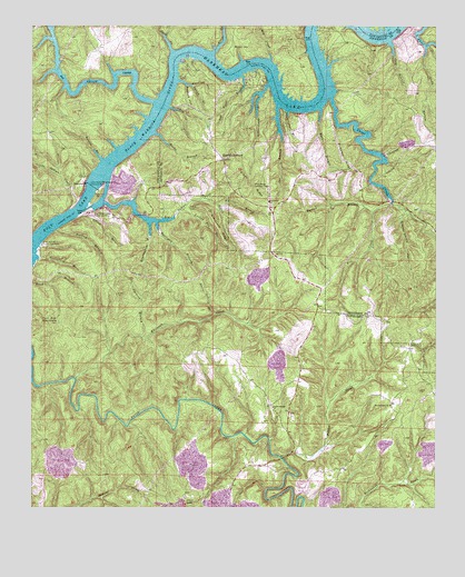
Burchfield Store, AL USGS Topographic Map
Click on map above to begin viewing in our Map Viewer.

This topographic map contains these locations and features:
Feature Name Type Latitude Longitude GNIS ID View Map
Allen School (historical)SchoolN33.4262°W87.2833°143963View Map
Antioch ChurchChurchN33.3862°W87.3086°147814View Map
Bankhead LakeReservoirN33.4796°W87.2956°113443View Map
Big Coal Bed BranchStreamN33.3940°W87.3089°147874View Map
Big CreekStreamN33.4915°W87.3028°114260View Map
Big Indian CreekStreamN33.4543°W87.3547°114289View Map
Big Indian Creek Public Use AreaParkN33.4512°W87.3567°114290View Map
Big Shoals CampLocaleN33.4551°W87.2647°144008View Map
Big Yellow CreekStreamN33.4804°W87.3383°114336View Map
Bradbottom BranchStreamN33.4493°W87.3394°114802View Map
Brown RidgeRidgeN33.4590°W87.3086°114997View Map
Bull CityPopulated PlaceN33.4165°W87.2583°115176View Map
Burchfield BranchStreamN33.4396°W87.3728°115213View Map
Burchfield StoreLocaleN33.4654°W87.3172°115214View Map
Burchfield Store High School (historical)SchoolN33.4654°W87.3169°144042View Map
Burke BranchStreamN33.4723°W87.3381°115229View Map
Burton BranchStreamN33.4540°W87.2644°115282View Map
Camp AldredgeLocaleN33.4993°W87.2856°144057View Map
Camp Hill (historical)LocaleN33.4562°W87.2667°144059View Map
Canoe BranchStreamN33.4779°W87.2972°115588View Map
Cold BranchStreamN33.4959°W87.2650°116386View Map
Community Camp (historical)LocaleN33.4868°W87.3033°144108View Map
Coon HollowValleyN33.4946°W87.2533°116563View Map
Devils Den BranchStreamN33.4254°W87.3189°117254View Map
Dunns BendBendN33.4987°W87.2681°148070View Map
Dunns CampLocaleN33.4862°W87.3289°144141View Map
Farleys SpringSpringN33.4365°W87.3333°148121View Map
Fox CreekStreamN33.4521°W87.2697°118580View Map
Granny Harris HollowValleyN33.4515°W87.2597°119234View Map
Graveyard RidgeRidgeN33.4479°W87.3178°119285View Map
Harrigan BranchStreamN33.4490°W87.3369°119784View Map
Hayes (historical)LocaleN33.3951°W87.2958°148214View Map
Howtons Ferry (historical)CrossingN33.4832°W87.2847°1987075View Map
Iron Ore MountainSummitN33.4237°W87.3722°120701View Map
Island BranchStreamN33.4507°W87.3586°112857View Map
Jackie Watson Redstone CampLocaleN33.4851°W87.3039°144304View Map
Jackson BranchStreamN33.4190°W87.3414°120756View Map
Joe BranchStreamN33.4790°W87.3003°151893View Map
John Hollis Bankhead Lock and DamDamN33.4582°W87.3567°151895View Map
Kings Marina CampLocaleN33.4907°W87.3286°144324View Map
Kirtley Marine CampLocaleN33.4859°W87.3111°144326View Map
Light House CampLocaleN33.4771°W87.2972°144346View Map
Little Indian CreekStreamN33.4526°W87.3639°121803View Map
Lock Number Eleven (historical)DamN33.4684°W87.3444°151621View Map
Lock Number Seventeen (historical)DamN33.4579°W87.3569°154291View Map
Lock Number Sixteen (historical)DamN33.4446°W87.3736°154292View Map
Nancy Ann BendBendN33.4959°W87.2819°144417View Map
Nathan BranchStreamN33.4471°W87.3675°123649View Map
Old Lock 16 Public Use AreaParkN33.4434°W87.3717°124222View Map
Patton CemeteryCemeteryN33.4532°W87.3272°124495View Map
Patton Ferry (historical)CrossingN33.4887°W87.3111°154258View Map
Pattons Mill (historical)LocaleN33.4643°W87.3036°144451View Map
Penney Point Lodge CampLocaleN33.4915°W87.2828°144452View Map
Poplar Springs ChurchChurchN33.4012°W87.3006°153042View Map
ProvidencePopulated PlaceN33.4529°W87.3000°144486View Map
Providence CemeteryCemeteryN33.4523°W87.3017°144487View Map
Providence ChurchChurchN33.4548°W87.3025°125333View Map
Providence Lookout TowerTowerN33.4587°W87.3069°164401View Map
Prudes CreekStreamN33.3884°W87.2975°125344View Map
Prudes Creek CemeteryCemeteryN33.4021°W87.2605°148465View Map
Prudes Creek Missionary Baptist ChurchChurchN33.4021°W87.2642°153088View Map
Prudes Creek School (historical)SchoolN33.4004°W87.2636°148466View Map
Pumpkin RidgeRidgeN33.4659°W87.2794°125363View Map
Redbud HollowValleyN33.4848°W87.3283°125501View Map
Shoal CreekStreamN33.4815°W87.2833°153437View Map
Spring BranchStreamN33.4857°W87.3308°127216View Map
Squaw Shoals (historical)BarN33.4640°W87.3514°148594View Map
Squaw Shoals (historical)LocaleN33.4584°W87.3603°148595View Map
Steep CreekStreamN33.4934°W87.3206°127349View Map
Suck CreekStreamN33.4934°W87.3331°127496View Map
Tan Troff BranchStreamN33.4871°W87.3119°153645View Map
Thompsons Mill (historical)LocaleN33.3837°W87.2869°148641View Map
Turkey Pen BranchStreamN33.4523°W87.3292°128174View Map
Warrior CemeteryCemeteryN33.4948°W87.3142°128596View Map
Warrior Church (historical)ChurchN33.4951°W87.3125°148715View Map
Watson BranchStreamN33.4654°W87.3542°128637View Map
Waxtree HollowValleyN33.4859°W87.3308°128656View Map
Whiteoak CreekStreamN33.4090°W87.3614°128906View Map
Wildcat BranchStreamN33.4534°W87.3181°128962View Map
Willowstump BranchStreamN33.4846°W87.3031°154001View Map
Works BranchStreamN33.4784°W87.2867°129237View Map
Yellow Creek CampLocaleN33.4779°W87.3317°140423View Map

Note: Coordinates in the location and feature list above are referenced to NAD83 datum.


Copyright (C) 2008-2024 Ryan Niemi / Sunset Dynamics ... All Rights Reserved