TopoQuest Logo
Do you find TopoQuest useful?
Help keep TopoQuest running and adding new maps/features by donating!
Bitcoin:  19c7KJd3qBynnjoSw5npx9KScwjBe4ifkT
Litecoin:  LXs6TkuXGGXo1vDsWCkWVdjQX94eUKd6ui
Home View Maps Find Maps Find Places Resources & Links


Windham Springs, Alabama Topographic Map

USGS Map Title: Windham Springs, AL
USGS Map MRC: 33087D4
DRG (GeoTIFF) Download: o33087d4.tif


Neighboring USGS Topographic Map Quads:


  Berry SE, AL  
33087E5
 

  Wiley, AL  
33087E4
 

  Tutwiler School, AL  
33087E3
 

  Lake Tuscaloosa North, AL  
33087D5
 

  Windham Springs, AL  
33087D4
 

  Burchfield Store, AL  
33087D3
 

  Lake Tuscaloosa South, AL  
33087C5
 

  Lake Nicol, AL  
33087C4
 

  Brookwood, AL  
33087C3


Map MRC Location:

N34°
W88°
N34°
W87°
H8 H7 H6 H5 H4 H3 H2 H1
G8 G7 G6 G5 G4 G3 G2 G1
F8 F7 F6 F5 F4 F3 F2 F1
E8 E7 E6 E5 E4 E3 E2 E1
D8 D7 D6 D5 D4 D3 D2 D1
C8 C7 C6 C5 C4 C3 C2 C1
B8 B7 B6 B5 B4 B3 B2 B1
A8 A7 A6 A5 A4 A3 A2 A1
N33°
W88°
N33°
W87°

Windham Springs, AL USGS 1:24K Topographic Map Preview:
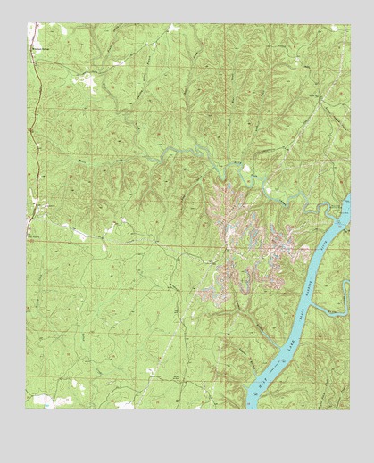
Windham Springs, AL USGS Topographic Map
Click on map above to begin viewing in our Map Viewer.

This topographic map contains these locations and features:
Feature Name Type Latitude Longitude GNIS ID View Map
Allgood BranchStreamN33.3857°W87.4106°113022View Map
Bear CreekStreamN33.4609°W87.4358°113670View Map
Blue CreekStreamN33.4365°W87.3808°114538View Map
Blue Creek Number 2 MineMineN33.4418°W87.4278°147885View Map
Blue Creek Public Use AreaParkN33.4393°W87.3806°114540View Map
Boyds Camp (historical)LocaleN33.4376°W87.3800°147892View Map
Charley Spring BranchStreamN33.4690°W87.4622°115972View Map
Crowder Shoals (historical)BarN33.4234°W87.3892°154288View Map
Davis CreekStreamN33.4098°W87.3900°117123View Map
Emily Number 5 MineMineN33.4793°W87.4972°148102View Map
Fair Shoals (historical)BarN33.3932°W87.3975°148112View Map
Harolds Lake (historical)LakeN33.3948°W87.4014°148209View Map
Jock CreekStreamN33.4534°W87.4283°120899View Map
Lick CreekStreamN33.4548°W87.4178°121592View Map
Little Bear CreekStreamN33.4554°W87.4222°121699View Map
Little Blue CreekStreamN33.4551°W87.4489°148334View Map
Lock Number Eight (historical)DamN33.4382°W87.3764°151548View Map
McDuff Spring BranchStreamN33.4979°W87.4753°122532View Map
Moore CreekStreamN33.4571°W87.4547°123010View Map
Panther BranchStreamN33.3948°W87.4014°152840View Map
Pewter CreekStreamN33.4846°W87.4728°124664View Map
Piney Wood CemeteryCemeteryN33.3812°W87.4369°158751View Map
Piney Woods ChurchChurchN33.4307°W87.4994°124884View Map
Piney Woods ChurchChurchN33.3809°W87.4542°155526View Map
Piney Woods School (historical)SchoolN33.4309°W87.4992°148451View Map
Pond BranchStreamN33.4340°W87.3772°125112View Map
Spencer Hill CemeteryCemeteryN33.4757°W87.3872°148585View Map
Spencer Hill ChurchChurchN33.4768°W87.3878°127183View Map
Spencer Hill School (historical)SchoolN33.4762°W87.3875°148586View Map
Turkey Creek MineMineN33.4140°W87.4958°148652View Map
Walton Road FordCrossingN33.3882°W87.4650°148710View Map
Windham SpringsPopulated PlaceN33.4915°W87.4986°154008View Map
Windham Springs Baptist ChurchChurchN33.4901°W87.4981°148754View Map
Windham Springs DivisionCivilN33.4642°W87.4635°165978View Map

Note: Coordinates in the location and feature list above are referenced to NAD83 datum.


Copyright (C) 2008-2025 Ryan Niemi / Sunset Dynamics ... All Rights Reserved