TopoQuest Logo
Do you find TopoQuest useful?
Help keep TopoQuest running and adding new maps/features by donating!
Bitcoin:  19c7KJd3qBynnjoSw5npx9KScwjBe4ifkT
Litecoin:  LXs6TkuXGGXo1vDsWCkWVdjQX94eUKd6ui
Home View Maps Find Maps Find Places Resources & Links


Burgettstown, Pennsylvania Topographic Map

USGS Map Title: Burgettstown, PA
USGS Map MRC: 40080D4
DRG (GeoTIFF) Download: o40080d4.tif


Neighboring USGS Topographic Map Quads:


  East Liverpool South, OH  
40080E5
 

  Hookstown, PA  
40080E4
 

  Aliquippa, PA  
40080E3
 

  Weirton, WV  
40080D5
 

  Burgettstown, PA  
40080D4
 

  Clinton, PA  
40080D3
 

  Steubenville East, OH  
40080C5
 

  Avella, PA  
40080C4
 

  Midway, PA  
40080C3


Map MRC Location:

N41°
W81°
N41°
W80°
H8 H7 H6 H5 H4 H3 H2 H1
G8 G7 G6 G5 G4 G3 G2 G1
F8 F7 F6 F5 F4 F3 F2 F1
E8 E7 E6 E5 E4 E3 E2 E1
D8 D7 D6 D5 D4 D3 D2 D1
C8 C7 C6 C5 C4 C3 C2 C1
B8 B7 B6 B5 B4 B3 B2 B1
A8 A7 A6 A5 A4 A3 A2 A1
N40°
W81°
N40°
W80°

Burgettstown, PA USGS 1:24K Topographic Map Preview:
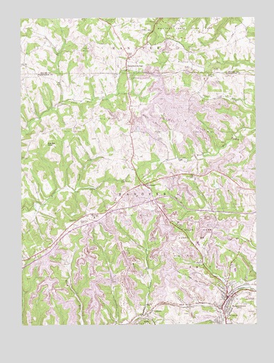
Burgettstown, PA USGS Topographic Map
Click on map above to begin viewing in our Map Viewer.

This topographic map contains these locations and features:
Feature Name Type Latitude Longitude GNIS ID View Map
BerthaPopulated PlaceN40.3776°W80.4323°1203071View Map
Bologna HeliportAirportN40.4167°W80.4220°1213772View Map
Borough of BurgettstownCivilN40.3813°W80.3926°1215653View Map
Borough of Frankfort SpringsCivilN40.4810°W80.4428°1214874View Map
BurgettstownPopulated PlaceN40.3820°W80.3928°1170713View Map
Burgettstown Community LibraryBuildingN40.3790°W80.3895°2430194View Map
Burgettstown Community ParkParkN40.3995°W80.3865°1170714View Map
Burgettstown Post OfficePost OfficeN40.3853°W80.3913°2779719View Map
Burgettstown Volunteer Fire Company Station 21BuildingN40.3822°W80.3927°2645117View Map
Chestnut Ridge CemeteryCemeteryN40.4169°W80.4694°1171747View Map
ComettsburgPopulated PlaceN40.4806°W80.4978°1201494View Map
DinsmorePopulated PlaceN40.3806°W80.4303°1203422View Map
Dinsmore ReservoirReservoirN40.3856°W80.4333°1194771View Map
Dinsmore Storage Number Two DamDamN40.3834°W80.4331°1194772View Map
Five PointsLocaleN40.4653°W80.4112°1201491View Map
Flood Dam 482DamN40.3951°W80.4531°1194787View Map
Flood Dam 483DamN40.3901°W80.4748°1194783View Map
FlorencePopulated PlaceN40.4323°W80.4337°1174913View Map
Francis MineLocaleN40.3820°W80.4103°1205173View Map
Frankfort SpringsPopulated PlaceN40.4790°W80.4426°1175136View Map
Frankfort SpringsSpringN40.4987°W80.4303°1202430View Map
Frankfort Springs (historical)LocaleN40.4976°W80.4276°1205172View Map
Frankfort Springs GrangeLocaleN40.4753°W80.4415°1175137View Map
Frankfort Springs Presbyterian Church CemeteryCemeteryN40.4802°W80.4423°2776006View Map
Frankfort Springs United Presbyterian Church CemeteryCemeteryN40.4850°W80.4408°2776007View Map
Grandview CemeteryCemeteryN40.4413°W80.4422°1175942View Map
HamiltonLocaleN40.4142°W80.4759°1212451View Map
Hanover Township SchoolSchoolN40.4187°W80.4606°1176483View Map
Hanover Volunteer Fire DepartmentBuildingN40.4106°W80.4839°2645105View Map
Jackson's Mill Covered BridgeBridgeN40.4239°W80.4892°2740715View Map
Miller Airport (historical)AirportN40.4570°W80.4367°1205119View Map
Our Lady of Lourdes CemeteryCemeteryN40.3875°W80.3759°1183116View Map
Pa-483 DamDamN40.3884°W80.4715°1194780View Map
Ponderosa Golflands Golf CourseLocaleN40.4909°W80.4428°1206173View Map
PurdyLocaleN40.4553°W80.4715°1212452View Map
State Game Lands Number 117ParkN40.4167°W80.3831°1208045View Map
Township of HanoverCivilN40.4314°W80.4528°1217193View Map
Tri-State Christian AcademySchoolN40.4202°W80.4608°2431606View Map
Tucker ChurchChurchN40.4181°W80.4698°1189905View Map
Union High SchoolSchoolN40.3787°W80.3906°1190157View Map
United ChurchChurchN40.4851°W80.4395°1190200View Map
Warriors PointCliffN40.4481°W80.4876°1190611View Map

Note: Coordinates in the location and feature list above are referenced to NAD83 datum.


Copyright (C) 2008-2024 Ryan Niemi / Sunset Dynamics ... All Rights Reserved