TopoQuest Logo
Do you find TopoQuest useful?
Help keep TopoQuest running and adding new maps/features by donating!
Bitcoin:  19c7KJd3qBynnjoSw5npx9KScwjBe4ifkT
Litecoin:  LXs6TkuXGGXo1vDsWCkWVdjQX94eUKd6ui
Home View Maps Find Maps Find Places Resources & Links


Clinton, Pennsylvania Topographic Map

USGS Map Title: Clinton, PA
USGS Map MRC: 40080D3
DRG (GeoTIFF) Download: o40080d3.tif


Neighboring USGS Topographic Map Quads:


  Hookstown, PA  
40080E4
 

  Aliquippa, PA  
40080E3
 

  Ambridge, PA  
40080E2
 

  Burgettstown, PA  
40080D4
 

  Clinton, PA  
40080D3
 

  Oakdale, PA  
40080D2
 

  Avella, PA  
40080C4
 

  Midway, PA  
40080C3
 

  Canonsburg, PA  
40080C2


Map MRC Location:

N41°
W81°
N41°
W80°
H8 H7 H6 H5 H4 H3 H2 H1
G8 G7 G6 G5 G4 G3 G2 G1
F8 F7 F6 F5 F4 F3 F2 F1
E8 E7 E6 E5 E4 E3 E2 E1
D8 D7 D6 D5 D4 D3 D2 D1
C8 C7 C6 C5 C4 C3 C2 C1
B8 B7 B6 B5 B4 B3 B2 B1
A8 A7 A6 A5 A4 A3 A2 A1
N40°
W81°
N40°
W80°

Clinton, PA USGS 1:24K Topographic Map Preview:
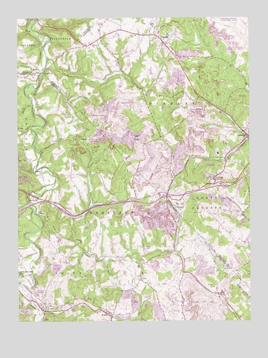
Clinton, PA USGS Topographic Map
Click on map above to begin viewing in our Map Viewer.

This topographic map contains these locations and features:
Feature Name Type Latitude Longitude GNIS ID View Map
BavingtonPopulated PlaceN40.4259°W80.3645°1168823View Map
Bigger RunStreamN40.4712°W80.3653°1169611View Map
Brush RunStreamN40.4551°W80.3670°1170459View Map
BulgerPopulated PlaceN40.3784°W80.3278°1170631View Map
Bulger Census Designated PlaceCensusN40.3766°W80.3230°2631253View Map
Burgetts ForkStreamN40.3892°W80.3740°1170712View Map
CandorPopulated PlaceN40.3920°W80.3090°1203218View Map
Chamberlain RunStreamN40.4448°W80.3631°1171536View Map
ChampionPopulated PlaceN40.4226°W80.2909°1203245View Map
Champion Number One Mine Refuse Bank DamDamN40.3884°W80.3065°1194779View Map
Champion Number One Mine Refuse Bank DamDamN40.4417°W80.3165°1194814View Map
ClintonPopulated PlaceN40.4895°W80.2945°1172012View Map
Clinton Census Designated PlaceCensusN40.4927°W80.2960°2631255View Map
Clinton Post OfficePost OfficeN40.4890°W80.2953°2777473View Map
Clinton United Presbyterian Church CemeteryCemeteryN40.4876°W80.2978°2774973View Map
CorkPopulated PlaceN40.4912°W80.3290°1201490View Map
Dilloe RunStreamN40.4648°W80.3667°1213956View Map
Fallen Timber Golf CourseLocaleN40.3895°W80.2909°1205571View Map
Findlay Township Police DepartmentBuildingN40.4898°W80.2964°2780241View Map
Frame FieldAirportN40.3967°W80.3039°1193966View Map
Hebron ChurchChurchN40.4890°W80.3345°1176742View Map
Hillman State ParkParkN40.4334°W80.3662°1196448View Map
Hopewell - Hebron CemeteryCemeteryN40.4885°W80.3345°1829108View Map
Imperial Volunteer Fire Department Station 152BuildingN40.4520°W80.2514°2644772View Map
JoffrePopulated PlaceN40.3792°W80.3603°1184570View Map
Joffre Census Designated PlaceCensusN40.3809°W80.3532°2631279View Map
Joffre Post OfficePost OfficeN40.3797°W80.3552°2779858View Map
Little Raccoon RunStreamN40.4295°W80.3567°1179653View Map
Marada Golf CourseLocaleN40.4945°W80.3076°1206148View Map
McAdamsPopulated PlaceN40.3862°W80.2678°1198230View Map
McDonald WaterworksLocaleN40.4223°W80.3356°1205170View Map
MurdocksvillePopulated PlaceN40.4787°W80.3559°1196542View Map
New DamDamN40.4301°W80.3365°1194805View Map
North Fork Montour RunStreamN40.4501°W80.2503°1182584View Map
Old DamDamN40.4234°W80.3365°1194798View Map
Pittsburgh International AirportAirportN40.4961°W80.2555°1194003View Map
Point PleasantCliffN40.4201°W80.3651°1184179View Map
Potato Garden RunStreamN40.4845°W80.3587°1184325View Map
Raccoon ChurchChurchN40.3937°W80.3081°1184571View Map
Risker FieldAirportN40.3780°W80.3506°2442835View Map
RobinsonPopulated PlaceN40.4503°W80.3367°1204524View Map
Saint Columbkille CemeteryCemeteryN40.4549°W80.2521°2775074View Map
Saint Patrick RunStreamN40.4173°W80.3448°1209318View Map
SantiagoPopulated PlaceN40.4342°W80.2706°1186977View Map
Sedimentation Pond Number ThreeReservoirN40.4417°W80.3169°1194815View Map
Shaw MineMineN40.3884°W80.2845°1205171View Map
Sludge Pond OneReservoirN40.3884°W80.3065°1194778View Map
South Fork Montour RunStreamN40.4501°W80.2503°1188066View Map
State Game Lands Number 117ParkN40.3931°W80.3734°1990205View Map
Township of FindlayCivilN40.4782°W80.2811°1215804View Map
Township of RobinsonCivilN40.4100°W80.3076°1217204View Map
Tyre Post OfficePost OfficeN40.4342°W80.2706°1214701View Map
VirsoixPopulated PlaceN40.4670°W80.3148°1196610View Map
Wingfield RunStreamN40.4787°W80.3615°1191599View Map

Note: Coordinates in the location and feature list above are referenced to NAD83 datum.


Copyright (C) 2008-2025 Ryan Niemi / Sunset Dynamics ... All Rights Reserved