TopoQuest Logo
Do you find TopoQuest useful?
Help keep TopoQuest running and adding new maps/features by donating!
Bitcoin:  19c7KJd3qBynnjoSw5npx9KScwjBe4ifkT
Litecoin:  LXs6TkuXGGXo1vDsWCkWVdjQX94eUKd6ui
Home View Maps Find Maps Find Places Resources & Links


Burnettsville, Indiana Topographic Map

USGS Map Title: Burnettsville, IN
USGS Map MRC: 40086G5
DRG (GeoTIFF) Download: o40086g5.tif


Neighboring USGS Topographic Map Quads:


  Buffalo, IN  
40086H6
 

  Star City, IN  
40086H5
 

  Grass Creek, IN  
40086H4
 

  Idaville, IN  
40086G6
 

  Burnettsville, IN  
40086G5
 

  Lucerne, IN  
40086G4
 

  Yeoman, IN  
40086F6
 

  Burrows, IN  
40086F5
 

  Clymers, IN  
40086F4


Map MRC Location:

N41°
W87°
N41°
W86°
H8 H7 H6 H5 H4 H3 H2 H1
G8 G7 G6 G5 G4 G3 G2 G1
F8 F7 F6 F5 F4 F3 F2 F1
E8 E7 E6 E5 E4 E3 E2 E1
D8 D7 D6 D5 D4 D3 D2 D1
C8 C7 C6 C5 C4 C3 C2 C1
B8 B7 B6 B5 B4 B3 B2 B1
A8 A7 A6 A5 A4 A3 A2 A1
N40°
W87°
N40°
W86°

Burnettsville, IN USGS 1:24K Topographic Map Preview:
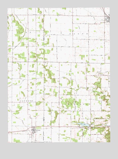
Burnettsville, IN USGS Topographic Map
Click on map above to begin viewing in our Map Viewer.

This topographic map contains these locations and features:
Feature Name Type Latitude Longitude GNIS ID View Map
Berkshire DitchCanalN40.8556°W86.5725°430845View Map
BurnettsvillePopulated PlaceN40.7612°W86.5936°431852View Map
Burnettsville Volunteer Fire DepartmentBuildingN40.7609°W86.5937°2626419View Map
Caley ChurchChurchN40.8687°W86.5911°431956View Map
Center ChurchChurchN40.8006°W86.5283°432325View Map
Crooked Creek ChurchChurchN40.8120°W86.5072°433167View Map
Davis CemeteryCemeteryN40.7655°W86.5743°433348View Map
Eastlawn Elementary SchoolSchoolN40.7598°W86.5931°447504View Map
Fredericks DitchCanalN40.8631°W86.5078°434793View Map
Galbreath DitchCanalN40.8006°W86.5589°434920View Map
Harness DitchCanalN40.8084°W86.5467°435755View Map
Houston DitchCanalN40.7789°W86.6145°436526View Map
Kennel DitchCanalN40.8606°W86.5608°437247View Map
Lake CicottLakeN40.7668°W86.5344°432521View Map
Lake CicottPopulated PlaceN40.7642°W86.5242°437524View Map
Lake Cicott Post OfficePost OfficeN40.7639°W86.5250°2080648View Map
Micro-Midget RacetrackLocaleN40.7648°W86.5050°452362View Map
Mortgage Trust DitchCanalN40.7900°W86.5411°439473View Map
Myers DitchCanalN40.8159°W86.5586°439919View Map
Strubhar DitchCanalN40.8559°W86.5375°444280View Map
Thompson CemeteryCemeteryN40.8681°W86.5625°444705View Map
Town of BurnettsvilleCivilN40.7611°W86.5947°2396620View Map
Township of BooneCivilN40.8670°W86.5244°453125View Map
Township of JacksonCivilN40.7805°W86.6053°453475View Map
Township of JeffersonCivilN40.7792°W86.5257°453481View Map
Zion CemeteryCemeteryN40.8245°W86.5800°446446View Map

Note: Coordinates in the location and feature list above are referenced to NAD83 datum.


Copyright (C) 2008-2025 Ryan Niemi / Sunset Dynamics ... All Rights Reserved