TopoQuest Logo
Do you find TopoQuest useful?
Help keep TopoQuest running and adding new maps/features by donating!
Bitcoin:  19c7KJd3qBynnjoSw5npx9KScwjBe4ifkT
Litecoin:  LXs6TkuXGGXo1vDsWCkWVdjQX94eUKd6ui
Home View Maps Find Maps Find Places Resources & Links


Burning Springs, West Virginia Topographic Map

USGS Map Title: Burning Springs, WV
USGS Map MRC: 38081H3
DRG (GeoTIFF) Download: o38081h3.tif


Neighboring USGS Topographic Map Quads:


  Elizabeth, WV  
39081A4
 

  Girta, WV  
39081A3
 

  MacFarlan, WV  
39081A2
 

  Reedy, WV  
38081H4
 

  Burning Springs, WV  
38081H3
 

  Annamoriah, WV  
38081H2
 

  Peniel, WV  
38081G4
 

  Spencer, WV  
38081G3
 

  Arnoldsburg, WV  
38081G2


Map MRC Location:

N39°
W82°
N39°
W81°
H8 H7 H6 H5 H4 H3 H2 H1
G8 G7 G6 G5 G4 G3 G2 G1
F8 F7 F6 F5 F4 F3 F2 F1
E8 E7 E6 E5 E4 E3 E2 E1
D8 D7 D6 D5 D4 D3 D2 D1
C8 C7 C6 C5 C4 C3 C2 C1
B8 B7 B6 B5 B4 B3 B2 B1
A8 A7 A6 A5 A4 A3 A2 A1
N38°
W82°
N38°
W81°

Burning Springs, WV USGS 1:24K Topographic Map Preview:
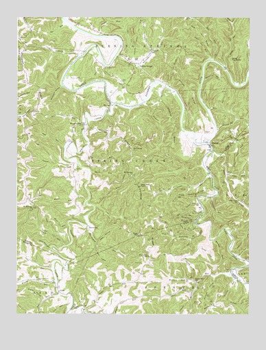
Burning Springs, WV USGS Topographic Map
Click on map above to begin viewing in our Map Viewer.

This topographic map contains these locations and features:
Feature Name Type Latitude Longitude GNIS ID View Map
Anns RunStreamN38.9331°W81.2696°1534967View Map
Anns Run School (historical)SchoolN38.9287°W81.2821°1678797View Map
Ball KnobSummitN38.9454°W81.3132°1535184View Map
Barnes RunStreamN38.8920°W81.2582°1535260View Map
Barnes Run School (historical)SchoolN38.8895°W81.2782°1535262View Map
Bear ForkStreamN38.9340°W81.2621°1535364View Map
Bear ForkStreamN38.9979°W81.2593°1535365View Map
Bear RunStreamN38.9548°W81.3382°1535392View Map
Bear RunStreamN38.8831°W81.3515°1535400View Map
Beatty School (historical)SchoolN38.9715°W81.3182°1678799View Map
Beaty CemeteryCemeteryN38.9720°W81.3176°1535441View Map
BeaverdamPopulated PlaceN38.9129°W81.3379°1553829View Map
Beaverdam RunStreamN38.9123°W81.3365°1535458View Map
Beaverdam School (historical)SchoolN38.9001°W81.3040°1535459View Map
Bell Lewis HollowValleyN38.9031°W81.3318°1535605View Map
Big RunStreamN38.9470°W81.3371°1535919View Map
Big RunStreamN38.9218°W81.2546°1535945View Map
Boggs School (historical)SchoolN38.8845°W81.3523°1740854View Map
Buck RunStreamN38.9048°W81.3498°1536565View Map
Burning SpringsPopulated PlaceN38.9812°W81.3140°1549617View Map
Burning Springs High School (historical)SchoolN38.9817°W81.3071°1678806View Map
Burning Springs Oil FieldOilfieldN38.9970°W81.3110°1557812View Map
Burning Springs RunStreamN38.9845°W81.3204°1536750View Map
Calm School (historical)SchoolN38.9948°W81.3679°1678808View Map
Cave HollowValleyN38.9070°W81.3318°1537112View Map
Coal RunStreamN38.8940°W81.3554°1537466View Map
CrestonPopulated PlaceN38.9470°W81.2710°1537816View Map
Creston BridgeBridgeN38.9481°W81.2711°2647342View Map
Creston FerryCrossingN38.9473°W81.2718°1678813View Map
Creston School (historical)SchoolN38.9442°W81.2712°1678815View Map
Creston United Methodist ChurchChurchN38.9454°W81.2715°1678816View Map
Dave Allen PointSummitN38.9301°W81.3085°1554261View Map
Davidson RidgeRidgeN38.9737°W81.3701°1538019View Map
Depue CemeteryCemeteryN38.9529°W81.2737°1538139View Map
Depue RidgeRidgeN38.9715°W81.2837°1538140View Map
Devils Tea TableSummitN38.9834°W81.2596°1554297View Map
Dry RunStreamN38.8776°W81.3468°1538385View Map
Dye RunStreamN38.9967°W81.3462°1538481View Map
Evelyn (historical)Populated PlaceN38.9384°W81.3443°1678819View Map
Fish RunStreamN38.9465°W81.3490°1538982View Map
Fishpot RunStreamN38.9651°W81.3065°1539008View Map
Fort HillSummitN38.9829°W81.3121°1554494View Map
Goosenest RunStreamN38.9245°W81.2693°1539530View Map
Goosenest School (historical)SchoolN38.9134°W81.2632°1696861View Map
GracePopulated PlaceN38.8859°W81.3529°1549712View Map
Grace Community ParkParkN38.8887°W81.3637°1539559View Map
Granny HollowValleyN38.8812°W81.3610°1539586View Map
Grannys RunStreamN38.8906°W81.2562°1539588View Map
Grape Hill FarmLocaleN38.9387°W81.3435°1678821View Map
Groundhog RidgeRidgeN38.9151°W81.3007°1539767View Map
Henthorn ForkStreamN38.8893°W81.2785°1540172View Map
HilbertPopulated PlaceN38.9223°W81.3671°1678822View Map
Hill Grove Baptist ChurchChurchN38.9551°W81.3404°1678823View Map
Hill Grove CemeteryCemeteryN38.9545°W81.3401°1678824View Map
Hill Grove School (historical)SchoolN38.9556°W81.3410°1540293View Map
Honey RunStreamN38.8990°W81.2562°1540423View Map
Hooam CemeteryCemeteryN38.8790°W81.3443°1540430View Map
Horse RunStreamN38.9237°W81.3376°1540495View Map
Island RunStreamN38.9534°W81.2673°1540746View Map
Island Run School (historical)SchoolN38.9567°W81.2543°1678825View Map
IvanPopulated PlaceN38.9842°W81.3426°1678826View Map
Kane RunStreamN38.9137°W81.3468°1541074View Map
Kanes School (historical)SchoolN38.9140°W81.3512°1678828View Map
Little Bear ForkStreamN38.9343°W81.2593°1542018View Map
Little CreekStreamN38.9440°W81.2698°1542069View Map
Little Creek SchoolSchoolN38.9229°W81.2557°1542076View Map
Little Lost RunStreamN38.9212°W81.3312°1542166View Map
Little Rockcamp RunStreamN38.9118°W81.2785°1542200View Map
Little Spring CreekStreamN38.8751°W81.3360°1542225View Map
Little Two RunStreamN38.9820°W81.2701°1551902View Map
Lost RunStreamN38.9212°W81.3332°1542466View Map
McCrae CemeteryCemeteryN38.9529°W81.2590°1542972View Map
Mile RunStreamN38.9615°W81.2718°1543272View Map
MillardPopulated PlaceN38.8787°W81.3335°1740945View Map
Millstone HollowValleyN38.9723°W81.3504°1543424View Map
Monroe RidgeRidgeN38.9504°W81.3226°1543500View Map
Mount Pleasant CemeteryCemeteryN38.9334°W81.3123°1852319View Map
Mount Pleasant ChurchChurchN38.9343°W81.3129°1543745View Map
Mount Pleasant School (historical)SchoolN38.9331°W81.3115°1678840View Map
Mount Solon CemeteryCemeteryN38.9367°W81.3437°1543765View Map
Mount Williams CemeteryCemeteryN38.9187°W81.3668°1678842View Map
Mount Williams ChurchChurchN38.9198°W81.3662°1543800View Map
Nettle RunStreamN38.9923°W81.3304°1544103View Map
Nichols HillSummitN38.8973°W81.2821°1555219View Map
Old Ruble School (historical)SchoolN38.9817°W81.3146°1678846View Map
Pack Saddle RidgeRidgeN38.9259°W81.2807°1544503View Map
Pack Saddle RunStreamN38.9223°W81.2760°1544504View Map
Petes RunStreamN38.9387°W81.2740°1544758View Map
Rector CemeteryCemeteryN38.9731°W81.3187°1545445View Map
Rector Methodist Church (historical)ChurchN38.9729°W81.3193°1678854View Map
Robert RunStreamN38.9409°W81.3476°1545840View Map
Rock RunStreamN38.9795°W81.2626°1545927View Map
Rockcamp RunStreamN38.9134°W81.2785°1545946View Map
Rose HillSummitN38.9084°W81.3096°1546070View Map
Ruble ChurchChurchN38.9812°W81.3135°1678860View Map
Salk Hill RidgeRidgeN38.9934°W81.2773°1546295View Map
Sand ForkStreamN38.9076°W81.2910°1546348View Map
SanomaPopulated PlaceN38.9645°W81.3246°1549912View Map
Sanoma BridgeBridgeN38.9647°W81.3247°2647343View Map
Short RunStreamN38.9356°W81.3360°1546731View Map
Siegret SpringSpringN38.9512°W81.2582°1678176View Map
Split Rock RunStreamN38.9031°W81.3568°1547151View Map
Spring CreekStreamN38.9637°W81.3235°1547186View Map
Spring Creek Truss BridgeBridgeN38.9528°W81.3390°2647344View Map
Spruce HollowValleyN38.9162°W81.2796°1547255View Map
Toms RunStreamN38.8773°W81.3382°1548147View Map
Turkey FlatsFlatN38.9023°W81.2718°1548336View Map
Turkey RunStreamN38.9070°W81.2687°1548353View Map
Two RunStreamN38.9820°W81.2693°1548417View Map
Two Run School (historical)SchoolN38.9992°W81.2796°1678869View Map
Umpsted RidgeRidgeN38.9573°W81.2923°1548456View Map
Vincent RunStreamN38.9837°W81.3418°1548674View Map
Vincent School (historical)SchoolN38.9817°W81.3590°1678874View Map
Wagon RunStreamN38.8890°W81.3532°1548705View Map
Wells ForkStreamN38.8859°W81.2798°1548902View Map
West Fork Little Kanawha RiverStreamN38.9473°W81.2718°1548928View Map
Williams HollowValleyN38.8912°W81.2687°1549176View Map
Woodring HollowValleyN38.9745°W81.2746°1549379View Map

Note: Coordinates in the location and feature list above are referenced to NAD83 datum.


Copyright (C) 2008-2025 Ryan Niemi / Sunset Dynamics ... All Rights Reserved