TopoQuest Logo
Do you find TopoQuest useful?
Help keep TopoQuest running and adding new maps/features by donating!
Bitcoin:  19c7KJd3qBynnjoSw5npx9KScwjBe4ifkT
Litecoin:  LXs6TkuXGGXo1vDsWCkWVdjQX94eUKd6ui
Home View Maps Find Maps Find Places Resources & Links


MacFarlan, West Virginia Topographic Map

USGS Map Title: MacFarlan, WV
USGS Map MRC: 39081A2
DRG (GeoTIFF) Download: o39081a2.tif


Neighboring USGS Topographic Map Quads:


  Petroleum, WV  
39081B3
 

  Cairo, WV  
39081B2
 

  Harrisville, WV  
39081B1
 

  Girta, WV  
39081A3
 

  MacFarlan, WV  
39081A2
 

  Smithville, WV  
39081A1
 

  Burning Springs, WV  
38081H3
 

  Annamoriah, WV  
38081H2
 

  Grantsville, WV  
38081H1


Map MRC Location:

N40°
W82°
N40°
W81°
H8 H7 H6 H5 H4 H3 H2 H1
G8 G7 G6 G5 G4 G3 G2 G1
F8 F7 F6 F5 F4 F3 F2 F1
E8 E7 E6 E5 E4 E3 E2 E1
D8 D7 D6 D5 D4 D3 D2 D1
C8 C7 C6 C5 C4 C3 C2 C1
B8 B7 B6 B5 B4 B3 B2 B1
A8 A7 A6 A5 A4 A3 A2 A1
N39°
W82°
N39°
W81°

MacFarlan, WV USGS 1:24K Topographic Map Preview:
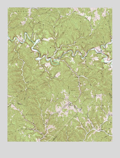
MacFarlan, WV USGS Topographic Map
Click on map above to begin viewing in our Map Viewer.

This topographic map contains these locations and features:
Feature Name Type Latitude Longitude GNIS ID View Map
Bear RunStreamN39.0945°W81.2379°1535394View Map
BeatricePopulated PlaceN39.0840°W81.1398°1535438View Map
Bell School (historical)SchoolN39.0067°W81.1293°1535607View Map
Bell School (historical)SchoolN39.0073°W81.2084°1535608View Map
Bell United Methodist ChurchChurchN39.0076°W81.2090°1535602View Map
Bethel ChapelChurchN39.0615°W81.1629°1535688View Map
Big Cave RunStreamN39.0781°W81.1593°1535814View Map
Bobs ForkStreamN39.1104°W81.1521°1536184View Map
BrohardPopulated PlaceN39.0365°W81.1762°1536384View Map
Brohard Community BuildingBuildingN39.0342°W81.1776°1678801View Map
Brohard Post OfficePost OfficeN39.0362°W81.1773°1678802View Map
Church of ChristChurchN39.0395°W81.1776°1688943View Map
Cole RunStreamN39.0104°W81.1382°1537510View Map
Daves RunStreamN39.0890°W81.1359°1538016View Map
Deem ChapelChurchN39.0845°W81.1393°1538104View Map
DutchmanPopulated PlaceN39.0606°W81.1651°1554341View Map
Dutchman RunStreamN39.0737°W81.1901°1538471View Map
Fivemile RunStreamN39.0079°W81.1551°1539030View Map
FreedPopulated PlaceN39.0109°W81.1379°1549692View Map
Hartley CemeteryCemeteryN39.0337°W81.1818°1540026View Map
Hartley School (historical)SchoolN39.0340°W81.1776°1540030View Map
Hoy ChapelChurchN39.0109°W81.1387°1540536View Map
Indian CreekStreamN39.0829°W81.1387°1540673View Map
Laurel RunStreamN39.0759°W81.2123°1541511View Map
Left Fork Dutchman RunStreamN39.0604°W81.1657°1541652View Map
Left Fork Macfarlan CreekStreamN39.0856°W81.1909°1541687View Map
Left Fork Straight CreekStreamN39.0054°W81.2059°1541733View Map
Lick RunStreamN39.0742°W81.1351°1541920View Map
Lick Run School (historical)SchoolN39.0679°W81.1365°1689000View Map
Louthers RunStreamN39.0954°W81.2240°1542484View Map
Lower Bear Run School (historical)SchoolN39.0748°W81.2304°1689006View Map
MacfarlanPopulated PlaceN39.0779°W81.1987°1542669View Map
Macfarlan CreekStreamN39.0767°W81.1990°1542670View Map
Macfarlan Post OfficePost OfficeN39.0781°W81.1989°1689009View Map
MellinPopulated PlaceN39.1226°W81.1709°1555105View Map
Mellin Post Office (historical)Post OfficeN39.1204°W81.1732°1689014View Map
Mount Zion ChurchChurchN39.0426°W81.1459°1543828View Map
Mudlick RunStreamN39.0548°W81.2284°1543963View Map
MundayPopulated PlaceN39.0054°W81.2062°1549842View Map
Munday Post OfficePost OfficeN39.0062°W81.2062°1678843View Map
Nutter CemeteryCemeteryN39.0950°W81.2338°1544255View Map
OxbowPopulated PlaceN39.0940°W81.2115°1549866View Map
Oxbow School (historical)SchoolN39.1020°W81.2290°1689026View Map
Pepper ForkStreamN39.0481°W81.2282°1544709View Map
Pleasant RidgeRidgeN39.0481°W81.1771°1545012View Map
Pleasant Ridge CemeteryCemeteryN39.0476°W81.1748°1545016View Map
Pleasant Ridge School (historical)SchoolN39.0470°W81.1751°1689037View Map
Red Ben School (historical)SchoolN39.0790°W81.1604°1689045View Map
Red Oak RunStreamN39.0495°W81.2276°1545460View Map
Ritchie Mine School (historical)SchoolN39.0815°W81.1715°1689051View Map
Ritchie Mines Wildlife Management AreaParkN39.1095°W81.1707°2043549View Map
Rock Run School (historical)SchoolN39.0323°W81.2401°1678857View Map
Straight Creek ChurchChurchN39.0342°W81.1773°1547551View Map
Straight ForkStreamN39.0156°W81.2043°1547558View Map
Threemile RunStreamN39.0117°W81.1471°1548080View Map
Threemile School (historical)SchoolN39.0240°W81.1529°1696934View Map
Twomile ChurchChurchN39.0340°W81.1376°1548429View Map
Twomile RunStreamN39.0231°W81.1301°1548439View Map
Upper Bear Run School (historical)SchoolN39.0412°W81.2418°1689078View Map
Wolverton CemeteryCemeteryN39.0109°W81.2154°1549363View Map

Note: Coordinates in the location and feature list above are referenced to NAD83 datum.


Copyright (C) 2008-2024 Ryan Niemi / Sunset Dynamics ... All Rights Reserved