TopoQuest Logo
Do you find TopoQuest useful?
Help keep TopoQuest running and adding new maps/features by donating!
Bitcoin:  19c7KJd3qBynnjoSw5npx9KScwjBe4ifkT
Litecoin:  LXs6TkuXGGXo1vDsWCkWVdjQX94eUKd6ui
Home View Maps Find Maps Find Places Resources & Links


Girta, West Virginia Topographic Map

USGS Map Title: Girta, WV
USGS Map MRC: 39081A3
DRG (GeoTIFF) Download: o39081a3.tif


Neighboring USGS Topographic Map Quads:


  Kanawha, WV  
39081B4
 

  Petroleum, WV  
39081B3
 

  Cairo, WV  
39081B2
 

  Elizabeth, WV  
39081A4
 

  Girta, WV  
39081A3
 

  MacFarlan, WV  
39081A2
 

  Reedy, WV  
38081H4
 

  Burning Springs, WV  
38081H3
 

  Annamoriah, WV  
38081H2


Map MRC Location:

N40°
W82°
N40°
W81°
H8 H7 H6 H5 H4 H3 H2 H1
G8 G7 G6 G5 G4 G3 G2 G1
F8 F7 F6 F5 F4 F3 F2 F1
E8 E7 E6 E5 E4 E3 E2 E1
D8 D7 D6 D5 D4 D3 D2 D1
C8 C7 C6 C5 C4 C3 C2 C1
B8 B7 B6 B5 B4 B3 B2 B1
A8 A7 A6 A5 A4 A3 A2 A1
N39°
W82°
N39°
W81°

Girta, WV USGS 1:24K Topographic Map Preview:
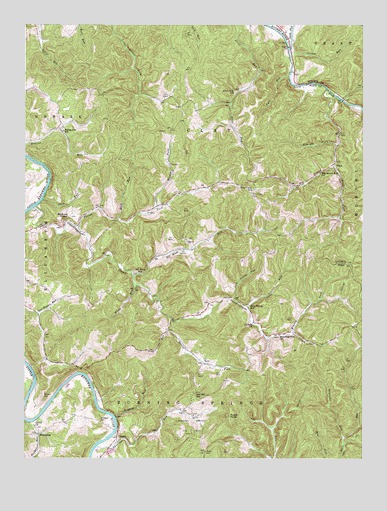
Girta, WV USGS Topographic Map
Click on map above to begin viewing in our Map Viewer.

This topographic map contains these locations and features:
Feature Name Type Latitude Longitude GNIS ID View Map
Big Island RunStreamN39.1065°W81.2632°1535870View Map
Big Island Run ChurchChurchN39.0823°W81.2654°1535871View Map
Brushy ForkStreamN39.0362°W81.2760°1536503View Map
Brushy Fork School (historical)SchoolN39.0370°W81.2748°1678803View Map
Buck RunStreamN39.0690°W81.3401°1536568View Map
Cave RunStreamN39.0745°W81.3685°1537114View Map
Cedar Hill School (historical)SchoolN39.0151°W81.3460°1678809View Map
CherryPopulated PlaceN39.0059°W81.3407°1549623View Map
Chestnut RunStreamN39.0034°W81.3479°1537300View Map
Cool Spring RunStreamN39.0459°W81.2973°1537607View Map
Cool Spring School (historical)SchoolN39.0442°W81.2921°1537608View Map
Deaver ForkStreamN39.0404°W81.3207°1538097View Map
Drift ForkStreamN39.0837°W81.2607°1538320View Map
EnterprisePopulated PlaceN39.0070°W81.3696°1549674View Map
Fall RunStreamN39.1104°W81.2773°1538848View Map
Flint Run School (historical)SchoolN39.1054°W81.2971°1539094View Map
GirtaPopulated PlaceN39.0851°W81.2604°1549705View Map
Guthrie CemeteryCemeteryN39.0390°W81.2901°1852314View Map
Guthrie United Methodist ChurchChurchN39.0392°W81.2904°1539802View Map
Henderson RunStreamN39.0104°W81.3729°1540149View Map
Highlog RunStreamN39.0117°W81.3412°1540275View Map
Horse RunStreamN39.0498°W81.3335°1540496View Map
Hughes River Wildlife Management AreaParkN39.1181°W81.3262°2043531View Map
Little Island Run School (historical)SchoolN39.1051°W81.3332°1678830View Map
Locust RunStreamN39.1165°W81.2771°1542303View Map
Lower Island Run School (historical)SchoolN39.0859°W81.2596°1689007View Map
McFee Sulphur SpringSpringN39.0073°W81.3257°1678177View Map
Morgan CemeteryCemeteryN39.0179°W81.3676°1543535View Map
North Fork Hughes RiverStreamN39.1181°W81.2773°1544210View Map
North Point School (historical)SchoolN39.0654°W81.3740°1678844View Map
Northeast DistrictCivilN39.0743°W81.3090°1928327View Map
Oil Rock RunStreamN39.0526°W81.3346°1544337View Map
Oil Rock School (historical)SchoolN39.0531°W81.3323°1544338View Map
Otter RunStreamN39.0431°W81.2923°1544465View Map
Owl Hill Methodist ChurchChurchN39.0187°W81.3121°1678848View Map
Owl Hill School (historical)SchoolN39.0181°W81.3118°1544493View Map
Parish ForkStreamN39.0670°W81.3565°1544572View Map
Parrish Fork School (historical)SchoolN39.0731°W81.3251°1678849View Map
Pine Twist Baptist ChurchChurchN39.0767°W81.2912°1678851View Map
Pine Twist CemeteryCemeteryN39.0765°W81.2915°1544908View Map
Pine Twist School (historical)SchoolN39.0776°W81.2904°1544909View Map
Rising Sun School (historical)SchoolN39.0942°W81.3612°1545761View Map
Rock Run School (historical)SchoolN39.1242°W81.3554°1678856View Map
Rockhold School (historical)SchoolN39.0695°W81.3582°1678859View Map
Ruble CemeteryCemeteryN39.0020°W81.3079°1546129View Map
Ruble KnobSummitN39.0123°W81.2993°1558385View Map
Saratoga CemeteryCemeteryN39.0106°W81.3471°1546432View Map
Sergeant RunStreamN39.0062°W81.2571°1546576View Map
Shiloh CemeteryCemeteryN39.0090°W81.3707°1678862View Map
Shiloh ChurchChurchN39.0092°W81.3710°1546687View Map
South Fork Hughes RiverStreamN39.1181°W81.2773°1547073View Map
Standingstone ChurchChurchN39.0354°W81.2807°1547328View Map
Standingstone CreekStreamN39.0726°W81.3710°1547329View Map
Straight ForkStreamN39.0904°W81.2596°1547560View Map
Trap RunStreamN39.0367°W81.3218°1548258View Map
Upper Island Run School (historical)SchoolN39.0815°W81.2671°1678872View Map
Wesleyan ChapelChurchN39.0692°W81.3587°1548920View Map
Wilson ForkStreamN39.0723°W81.3260°1549221View Map

Note: Coordinates in the location and feature list above are referenced to NAD83 datum.


Copyright (C) 2008-2024 Ryan Niemi / Sunset Dynamics ... All Rights Reserved