TopoQuest Logo
Do you find TopoQuest useful?
Help keep TopoQuest running and adding new maps/features by donating!
Bitcoin:  19c7KJd3qBynnjoSw5npx9KScwjBe4ifkT
Litecoin:  LXs6TkuXGGXo1vDsWCkWVdjQX94eUKd6ui
Home View Maps Find Maps Find Places Resources & Links


Byars, Oklahoma Topographic Map

USGS Map Title: Byars, OK
USGS Map MRC: 34097G1
DRG (GeoTIFF) Download: o34097g1.tif


Neighboring USGS Topographic Map Quads:


  Rosedale, OK  
34097H2
 

  Wanette, OK  
34097H1
 

  Asher, OK  
34096H8
 

  Byars SW, OK  
34097G2
 

  Byars, OK  
34097G1
 

  Stratford, OK  
34096G8
 

  Pauls Valley, OK  
34097F2
 

  Pauls Valley NE, OK  
34097F1
 

  Hart, OK  
34096F8


Map MRC Location:

N35°
W98°
N35°
W97°
H8 H7 H6 H5 H4 H3 H2 H1
G8 G7 G6 G5 G4 G3 G2 G1
F8 F7 F6 F5 F4 F3 F2 F1
E8 E7 E6 E5 E4 E3 E2 E1
D8 D7 D6 D5 D4 D3 D2 D1
C8 C7 C6 C5 C4 C3 C2 C1
B8 B7 B6 B5 B4 B3 B2 B1
A8 A7 A6 A5 A4 A3 A2 A1
N34°
W98°
N34°
W97°

Byars, OK USGS 1:24K Topographic Map Preview:
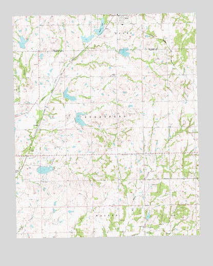
Byars, OK USGS Topographic Map
Click on map above to begin viewing in our Map Viewer.

This topographic map contains these locations and features:
Feature Name Type Latitude Longitude GNIS ID View Map
Abney CemeteryCemeteryN34.7821°W97.0247°1089513View Map
BoudinotPopulated PlaceN34.8134°W97.1084°1100223View Map
ByarsPopulated PlaceN34.8742°W97.0500°1090771View Map
Byars CemeteryCemeteryN34.8676°W97.0367°1090772View Map
Byars Elementary SchoolSchoolN34.8692°W97.0506°1790580View Map
Byars LakeReservoirN34.8675°W97.0653°1090773View Map
Byars Lake DamDamN34.8651°W97.0670°1752319View Map
Byars Volunteer Fire DepartmentBuildingN34.8737°W97.0534°2658593View Map
Cherokee Sandy Site 3 DamDamN34.7684°W97.0486°1758410View Map
Cherokee Sandy Site 3 ReservoirReservoirN34.7684°W97.0486°1758411View Map
Cherokee Sandy Site 4 DamDamN34.7601°W97.0370°1758408View Map
Cherokee Sandy Site 4 ReservoirReservoirN34.7601°W97.0370°1758409View Map
Cherokee Sandy Site 6 DamDamN34.8067°W97.0186°1754785View Map
Cherokee Sandy Site 6 ReservoirReservoirN34.8067°W97.0186°1754786View Map
Civit CemeteryCemeteryN34.7993°W97.1140°1091379View Map
Clabber Flats CemeteryCemeteryN34.7556°W97.0377°1091381View Map
Dixon Chapel CemeteryCemeteryN34.8407°W97.0582°2708924View Map
Dixon Chapel Presbyterian ChurchChurchN34.8409°W97.0575°1092105View Map
Northeast Civit Oil FieldOilfieldN34.7976°W97.0953°1096019View Map
Oknoname 04921 DamDamN34.8501°W97.1053°1758339View Map
Oknoname 04921 ReservoirReservoirN34.8501°W97.1053°1758340View Map
Peavine Creek Site 1 DamDamN34.7901°W97.1086°1758996View Map
Peavine Creek Site 1 ReservoirReservoirN34.7901°W97.1086°1758997View Map
Peavine Creek Site 11 DamDamN34.8567°W97.1220°1756399View Map
Peavine Creek Site 11 ReservoirReservoirN34.8567°W97.1220°1756400View Map
Peavine Creek Site 2 DamDamN34.8167°W97.0836°1758994View Map
Peavine Creek Site 2 ReservoirReservoirN34.8167°W97.0836°1758995View Map
Peavine Creek Site 3 DamDamN34.8301°W97.0920°1758992View Map
Peavine Creek Site 3 ReservoirReservoirN34.8301°W97.0920°1758993View Map
Peavine Creek Site 4 DamDamN34.8534°W97.0520°1758990View Map
Peavine Creek Site 4 ReservoirReservoirN34.8534°W97.0520°1758991View Map
Peavine Creek Site 5 DamDamN34.8601°W97.0770°1756401View Map
Peavine Creek Site 5 ReservoirReservoirN34.8601°W97.0770°1756402View Map
Peavine Creek Site 6 DamDamN34.8434°W97.1003°1759004View Map
Peavine Creek Site 6 ReservoirReservoirN34.8434°W97.1003°1759005View Map
Town of ByarsCivilN34.8724°W97.0541°2413142View Map
Township of StratfordCivilN34.8098°W97.0642°1824728View Map

Note: Coordinates in the location and feature list above are referenced to NAD83 datum.


Copyright (C) 2008-2024 Ryan Niemi / Sunset Dynamics ... All Rights Reserved