TopoQuest Logo
Do you find TopoQuest useful?
Help keep TopoQuest running and adding new maps/features by donating!
Bitcoin:  19c7KJd3qBynnjoSw5npx9KScwjBe4ifkT
Litecoin:  LXs6TkuXGGXo1vDsWCkWVdjQX94eUKd6ui
Home View Maps Find Maps Find Places Resources & Links


Cairo, West Virginia Topographic Map

USGS Map Title: Cairo, WV
USGS Map MRC: 39081B2
DRG (GeoTIFF) Download: o39081b2.tif


Neighboring USGS Topographic Map Quads:


  Willow Island, WV  
39081C3
 

  Schultz, WV  
39081C2
 

  Ellenboro, WV  
39081C1
 

  Petroleum, WV  
39081B3
 

  Cairo, WV  
39081B2
 

  Harrisville, WV  
39081B1
 

  Girta, WV  
39081A3
 

  MacFarlan, WV  
39081A2
 

  Smithville, WV  
39081A1


Map MRC Location:

N40°
W82°
N40°
W81°
H8 H7 H6 H5 H4 H3 H2 H1
G8 G7 G6 G5 G4 G3 G2 G1
F8 F7 F6 F5 F4 F3 F2 F1
E8 E7 E6 E5 E4 E3 E2 E1
D8 D7 D6 D5 D4 D3 D2 D1
C8 C7 C6 C5 C4 C3 C2 C1
B8 B7 B6 B5 B4 B3 B2 B1
A8 A7 A6 A5 A4 A3 A2 A1
N39°
W82°
N39°
W81°

Cairo, WV USGS 1:24K Topographic Map Preview:
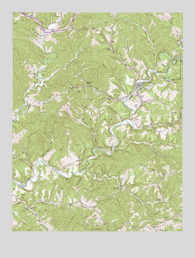
Cairo, WV USGS Topographic Map
Click on map above to begin viewing in our Map Viewer.

This topographic map contains these locations and features:
Feature Name Type Latitude Longitude GNIS ID View Map
Addis RunStreamN39.1851°W81.1615°1534811View Map
Big RunStreamN39.2101°W81.1590°1535931View Map
Big Run ChurchChurchN39.2334°W81.1779°1535958View Map
Big Run School (historical)SchoolN39.2334°W81.1776°1688927View Map
Buky RunStreamN39.2162°W81.1457°1536681View Map
Buky Run School (historical)SchoolN39.2429°W81.1565°1688931View Map
Cabin RunStreamN39.1604°W81.2323°1536836View Map
Cabin Run School (historical)SchoolN39.1676°W81.2382°1688934View Map
CairoPopulated PlaceN39.2087°W81.1573°1536852View Map
Cairo ChurchChurchN39.1970°W81.1565°1536853View Map
Cairo Elementary School (historical)SchoolN39.2087°W81.1598°1688935View Map
Cairo Middle School (historical)SchoolN39.2079°W81.1604°1688936View Map
Cairo Post OfficePost OfficeN39.2086°W81.1561°1688937View Map
Cairo Volunteer Fire DepartmentBuildingN39.2093°W81.1566°2577951View Map
CantwellPopulated PlaceN39.1326°W81.1312°1549619View Map
Cow RunStreamN39.1584°W81.2032°1537747View Map
Davisson ChapelChurchN39.2115°W81.1340°1538057View Map
Devilhole CreekStreamN39.1609°W81.1946°1538155View Map
Donohue Post Office (historical)Post OfficeN39.2084°W81.1962°1688954View Map
Elfritz CemeteryCemeteryN39.2140°W81.2290°1538592View Map
Elliotts RunStreamN39.2470°W81.2340°1551054View Map
Elm RunStreamN39.1698°W81.1768°1538690View Map
Elm Run School (historical)SchoolN39.1701°W81.1434°1688959View Map
Goose Creek CemeteryCemeteryN39.2145°W81.2329°1539520View Map
Goose Run ChurchChurchN39.2092°W81.2273°1539527View Map
Grant DistrictCivilN39.2105°W81.1872°1928280View Map
Heck CemeteryCemeteryN39.1423°W81.1965°1540117View Map
International Order of Odd Fellows CemeteryCemeteryN39.1972°W81.1581°2586339View Map
Jackson School (historical)SchoolN39.1284°W81.2257°1688990View Map
Lamb CemeteryCemeteryN39.2048°W81.2023°1541321View Map
Little Devilhole CreekStreamN39.1584°W81.2004°1542087View Map
Log ChurchChurchN39.1273°W81.1454°1542306View Map
Long RunStreamN39.2112°W81.2290°1542407View Map
Low GapPopulated PlaceN39.2112°W81.1329°1549800View Map
Low Gap RunStreamN39.2154°W81.1443°1542510View Map
Low Gap School (historical)SchoolN39.2120°W81.1251°1689004View Map
Lower Addis Run School (historical)SchoolN39.1859°W81.1484°1689005View Map
Lynch CemeteryCemeteryN39.2165°W81.1443°1542626View Map
Lynn RunStreamN39.1912°W81.2468°1542646View Map
Marietta RunStreamN39.2370°W81.2273°1542762View Map
Mason CemeteryCemeteryN39.1362°W81.2312°1542847View Map
Metz CemeteryCemeteryN39.1929°W81.2296°1543145View Map
Morris ChapelChurchN39.1273°W81.1604°1543569View Map
North Fork ChurchChurchN39.1381°W81.2371°1544206View Map
Number One West of Cornwallis DamDamN39.2251°W81.1282°1559291View Map
Nutter FarmPopulated PlaceN39.2409°W81.2248°1544258View Map
Nutter Farm School (historical)SchoolN39.2431°W81.2290°1689019View Map
Nutter ForkStreamN39.2373°W81.2248°1544259View Map
Oil RidgeRidgeN39.1592°W81.1284°1544335View Map
Oil Ridge ChurchChurchN39.1598°W81.1451°1544336View Map
Oil Ridge School (historical)SchoolN39.1590°W81.1443°1689023View Map
Pew HillPopulated PlaceN39.1823°W81.1440°1549874View Map
Phillips School (historical)SchoolN39.1656°W81.1993°1689031View Map
RacyPopulated PlaceN39.1387°W81.2379°1555432View Map
Rexroach CemeteryCemeteryN39.2381°W81.2257°1545515View Map
Right Fork Big RunStreamN39.2179°W81.1615°1545613View Map
Right Fork Gillespie RunStreamN39.1381°W81.2382°1545645View Map
RiversidePopulated PlaceN39.1729°W81.1768°1555486View Map
Rocky ForkStreamN39.1501°W81.1671°1546017View Map
Rush RunStreamN39.1940°W81.1609°1546174View Map
RutherfordPopulated PlaceN39.1506°W81.1707°1549908View Map
Saint Williams ChurchChurchN39.2029°W81.1573°1546275View Map
Sheep RunStreamN39.1715°W81.1896°1546652View Map
Short RunStreamN39.2129°W81.2309°1546736View Map
Short Run School (historical)SchoolN39.2123°W81.2315°1689057View Map
Silver RunStreamN39.1995°W81.1679°1546785View Map
Silver Run StationLocaleN39.2084°W81.1971°1546787View Map
Six CemeteryCemeteryN39.1907°W81.1297°1546847View Map
Six HillPopulated PlaceN39.1942°W81.1326°1555634View Map
Slaughterhouse RunStreamN39.1867°W81.1704°1546926View Map
Stewart CemeteryCemeteryN39.2101°W81.2301°1547402View Map
Sugarcamp RunStreamN39.1876°W81.1268°1547693View Map
Swisher CemeteryCemeteryN39.1643°W81.2239°1547809View Map
Tarkiln School (historical)SchoolN39.1270°W81.2473°1689068View Map
Town of CairoCivilN39.2067°W81.1543°2390764View Map
Tunnel Number 19TunnelN39.2079°W81.2054°1557899View Map
Upper Cabin RunStreamN39.1651°W81.2296°1548509View Map
Upper Devil Hole School (historical)SchoolN39.1434°W81.1571°1689079View Map
Victory School (historical)SchoolN39.1976°W81.2404°1689080View Map
Wildcat RunStreamN39.2009°W81.1651°1549138View Map

Note: Coordinates in the location and feature list above are referenced to NAD83 datum.


Copyright (C) 2008-2025 Ryan Niemi / Sunset Dynamics ... All Rights Reserved