TopoQuest Logo
Do you find TopoQuest useful?
Help keep TopoQuest running and adding new maps/features by donating!
Bitcoin:  19c7KJd3qBynnjoSw5npx9KScwjBe4ifkT
Litecoin:  LXs6TkuXGGXo1vDsWCkWVdjQX94eUKd6ui
Home View Maps Find Maps Find Places Resources & Links


Rocky Mount, Virginia Topographic Map

USGS Map Title: Rocky Mount, VA
USGS Map MRC: 36079H8
DRG (GeoTIFF) Download: o36079h8.tif


Neighboring USGS Topographic Map Quads:


  Callaway, VA  
37080A1
 

  Boones Mill, VA  
37079A8
 

  Redwood, VA  
37079A7
 

  Ferrum, VA  
36080H1
 

  Rocky Mount, VA  
36079H8
 

  Gladehill, VA  
36079H7
 

  Philpott Lake, VA  
36080G1
 

  Bassett, VA  
36079G8
 

  Snow Creek, VA  
36079G7


Map MRC Location:

N37°
W80°
N37°
W79°
H8 H7 H6 H5 H4 H3 H2 H1
G8 G7 G6 G5 G4 G3 G2 G1
F8 F7 F6 F5 F4 F3 F2 F1
E8 E7 E6 E5 E4 E3 E2 E1
D8 D7 D6 D5 D4 D3 D2 D1
C8 C7 C6 C5 C4 C3 C2 C1
B8 B7 B6 B5 B4 B3 B2 B1
A8 A7 A6 A5 A4 A3 A2 A1
N36°
W80°
N36°
W79°

Rocky Mount, VA USGS 1:24K Topographic Map Preview:
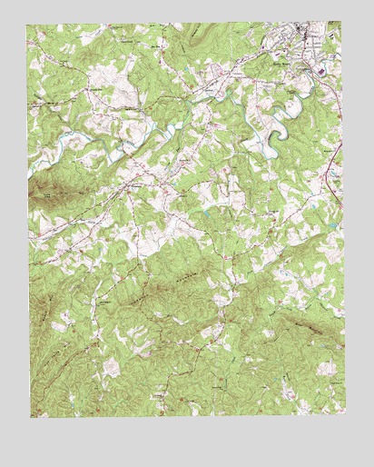
Rocky Mount, VA USGS Topographic Map
Click on map above to begin viewing in our Map Viewer.

This topographic map contains these locations and features:
Feature Name Type Latitude Longitude GNIS ID View Map
Angle CemeteryCemeteryN36.9346°W79.9900°1791213View Map
Antioch CemeteryCemeteryN36.9454°W79.9395°1494380View Map
Antioch ChurchChurchN36.9454°W79.9389°1462499View Map
Bald KnobSummitN36.9996°W79.8781°1499080View Map
BarfootPopulated PlaceN36.9785°W79.9295°1499088View Map
Beech MountainSummitN36.9118°W79.9914°1500062View Map
Belcher CemeteryCemeteryN36.9874°W79.8903°1791215View Map
Bowles CemeteryCemeteryN36.9443°W79.9636°1791218View Map
Brier MountainSummitN36.9010°W79.8873°1463818View Map
Brier Mountain School (historical)SchoolN36.8971°W79.9106°1494398View Map
Canton Creek CemeteryCemeteryN36.8832°W79.9234°1791222View Map
Canton Creek ChurchChurchN36.8832°W79.9242°1464421View Map
Carilion Franklin Memorial HospitalHospitalN36.9940°W79.8903°1494437View Map
Cassells Mill (historical)LocaleN36.9585°W79.9123°1494404View Map
Center Ridge School (historical)SchoolN36.9338°W79.9173°1494406View Map
Christian Heritage AcademySchoolN36.9732°W79.8945°2498397View Map
Clearview CemeteryCemeteryN36.9701°W79.9656°1494405View Map
Coles CreekLocaleN36.9940°W79.9561°1465097View Map
Coles Creek ChurchChurchN36.9988°W79.9664°1465100View Map
Cooks KnobSummitN36.9457°W79.9909°1465198View Map
Cooks Knob School (historical)SchoolN36.9426°W79.9734°1494408View Map
Dryland School (historical)SchoolN36.9349°W79.9561°1494420View Map
Ebenezer ChurchChurchN36.9740°W79.9984°1466140View Map
Fairview CemeteryCemeteryN36.9560°W79.9367°1494427View Map
Fairview ChurchChurchN36.9560°W79.9373°1466414View Map
Falling RunStreamN36.9663°W79.9386°1466463View Map
Ferguson School (historical)SchoolN36.9729°W79.9742°1494428View Map
Franklin CountyCivilN36.9920°W79.8811°1494434View Map
Franklin County CourthouseBuildingN36.9951°W79.8886°1494435View Map
Franklin County Rescue Squad - Squad 2BuildingN36.9955°W79.8907°2086287View Map
Franklin County Sheriff's OfficeBuildingN36.9954°W79.8880°2766980View Map
Furnace CreekStreamN36.9846°W79.8878°1466929View Map
Furnace Creek ChurchChurchN36.9807°W79.9017°1466930View Map
Greer-Ferguson CemeteryCemeteryN36.9982°W79.9095°1791229View Map
Hall CemeteryCemeteryN36.9040°W79.9834°1791231View Map
Hancock School (historical)SchoolN36.9190°W79.9178°1494443View Map
Handy CemeteryCemeteryN36.9940°W79.9967°1791233View Map
Harrison CemeteryCemeteryN36.9518°W79.8864°1791234View Map
Hatchet CreekStreamN36.9660°W79.9814°1467827View Map
Haw Patch HillSummitN36.8937°W79.9903°1467839View Map
Hay RunPopulated PlaceN36.9921°W79.9464°1477401View Map
Helms-Dyer CemeteryCemeteryN36.9457°W79.9436°1791236View Map
Hodges CemeteryCemeteryN36.9754°W79.9823°1791237View Map
Hodges CemeteryCemeteryN36.9687°W79.9084°1791238View Map
Hodges-Austin CemeteryCemeteryN36.9487°W79.9450°1791239View Map
Hodges-Love CemeteryCemeteryN36.8921°W79.8809°1791240View Map
Holland CemeteryCemeteryN36.9754°W79.8792°1791241View Map
Law CemeteryCemeteryN36.9618°W79.8867°1791245View Map
Lee M Waid Elementary SchoolSchoolN36.9954°W79.8793°1476221View Map
Lee School (historical)SchoolN36.9126°W79.8828°1494452View Map
Love CemeteryCemeteryN36.8943°W79.9139°1791247View Map
Love CemeteryCemeteryN36.8824°W79.8961°1791248View Map
Mason School (historical)SchoolN36.9129°W79.9670°1494458View Map
McGhee-Taylor CemeteryCemeteryN36.8771°W79.9445°1791249View Map
McGuire CemeteryCemeteryN36.8971°W79.8884°1791250View Map
Menefee CemeteryCemeteryN36.9371°W79.9178°1791253View Map
Mink DamDamN36.9351°W79.8781°1489814View Map
Minton CemeteryCemeteryN36.9832°W79.9759°1791255View Map
Morningside ChurchChurchN36.9588°W79.8781°1470750View Map
New Hope ChurchChurchN36.9871°W79.9856°1471435View Map
Nichols-Hodges-Davis CemeteryCemeteryN36.9537°W79.9186°1791258View Map
Oakes Dairy FarmLocaleN36.9606°W79.9603°2675258View Map
Peter Saunders BridgeBridgeN36.9843°W79.8873°1494483View Map
Pigg River ChurchChurchN36.9729°W79.9564°1472298View Map
Pigg River School (historical)SchoolN36.9754°W79.9084°1494487View Map
Piney Grove ChurchChurchN36.8849°W79.8814°1472400View Map
Pleasant Hill CemeteryCemeteryN36.9393°W79.9039°1494488View Map
Pleasant Hill ChurchChurchN36.9388°W79.9036°1472496View Map
Pleasant Hill School (historical)SchoolN36.9399°W79.8923°1494489View Map
Providence CemeteryCemeteryN36.8804°W79.9478°1494491View Map
Providence ChurchChurchN36.8807°W79.9481°1472819View Map
Providence School (historical)SchoolN36.8832°W79.9461°1494492View Map
Quinn CemeteryCemeteryN36.9468°W79.8834°1791264View Map
Rigney CemeteryCemeteryN36.9751°W79.8792°1791266View Map
Rock Ridge CemeteryCemeteryN36.9110°W79.9717°1791267View Map
Rock Ridge ChurchChurchN36.9115°W79.9723°1473385View Map
Rocky MountPopulated PlaceN36.9976°W79.8920°1499983View Map
Rocky Mount Post OfficePost OfficeN36.9973°W79.8928°2766287View Map
Sheeler School (historical)SchoolN36.9474°W79.9428°1494509View Map
Sixmile PostLocaleN36.9790°W79.9759°1474637View Map
Sloan CemeteryCemeteryN36.8804°W79.9709°1791270View Map
Smith School (historical)SchoolN36.9185°W79.9778°1494512View Map
Story CreekStreamN36.9643°W79.9092°1477934View Map
Story Creek Baptist ChurchChurchN36.9426°W79.9600°1494517View Map
Story Creek CemeteryCemeteryN36.9476°W79.9606°1494518View Map
Taylor School (historical)SchoolN36.8846°W79.9728°1494521View Map
Thornton MountainSummitN36.9140°W79.9523°1475671View Map
Virginia Western Community College - The Franklin CenterSchoolN36.9985°W79.8909°2498505View Map
Wade CemeteryCemeteryN36.9490°W79.9625°1791275View Map
WaidsboroPopulated PlaceN36.9488°W79.9598°1500266View Map
WNLB-AM (Rocky Mount)TowerN36.9771°W79.8956°1498955View Map
Worley FieldAirportN36.9501°W79.8795°1498803View Map
WZBB-FM (Rocky Mount)TowerN36.9771°W79.8956°1499004View Map
Young CemeteryCemeteryN36.9046°W79.9178°1791286View Map
Young CemeteryCemeteryN36.9060°W79.9736°1791287View Map
Young CemeteryCemeteryN36.8799°W79.9734°1791288View Map
Young CemeteryCemeteryN36.9660°W79.9292°1791289View Map

Note: Coordinates in the location and feature list above are referenced to NAD83 datum.


Copyright (C) 2008-2024 Ryan Niemi / Sunset Dynamics ... All Rights Reserved