TopoQuest Logo
Do you find TopoQuest useful?
Help keep TopoQuest running and adding new maps/features by donating!
Bitcoin:  19c7KJd3qBynnjoSw5npx9KScwjBe4ifkT
Litecoin:  LXs6TkuXGGXo1vDsWCkWVdjQX94eUKd6ui
Home View Maps Find Maps Find Places Resources & Links


Camas Valley, Oregon Topographic Map

USGS Map Title: Camas Valley, OR
USGS Map MRC: 43123A6
DRG (GeoTIFF) Download: o43123a6.tif


Neighboring USGS Topographic Map Quads:


  Sitkum, OR  
43123B7
 

  Mount Gurney, OR  
43123B6
 

  Reston, OR  
43123B5
 

  Kenyon Mountain, OR  
43123A7
 

  Camas Valley, OR  
43123A6
 

  Tenmile, OR  
43123A5
 

  Bone Mountain, OR  
42123H7
 

  Chipmunk Ridge, OR  
42123H6
 

  Live Oak Mountain, OR  
42123H5


Map MRC Location:

N44°
W124°
N44°
W123°
H8 H7 H6 H5 H4 H3 H2 H1
G8 G7 G6 G5 G4 G3 G2 G1
F8 F7 F6 F5 F4 F3 F2 F1
E8 E7 E6 E5 E4 E3 E2 E1
D8 D7 D6 D5 D4 D3 D2 D1
C8 C7 C6 C5 C4 C3 C2 C1
B8 B7 B6 B5 B4 B3 B2 B1
A8 A7 A6 A5 A4 A3 A2 A1
N43°
W124°
N43°
W123°

Camas Valley, OR USGS 1:24K Topographic Map Preview:
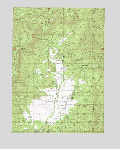
Camas Valley, OR USGS Topographic Map
Click on map above to begin viewing in our Map Viewer.

This topographic map contains these locations and features:
Feature Name Type Latitude Longitude GNIS ID View Map
Bar CreekStreamN43.0565°W123.6826°1117229View Map
Barnhart ReservoirReservoirN43.0173°W123.6915°1160895View Map
Bennett RockSummitN43.1137°W123.6709°1117532View Map
Big Burn CampLocaleN43.0012°W123.6567°1132422View Map
Bingham CreekStreamN43.0059°W123.7265°1117714View Map
Camas MountainSummitN43.0390°W123.6398°1118479View Map
Camas Mountain State Park (historical)ParkN43.0654°W123.6523°1118480View Map
Camas ValleyPopulated PlaceN43.0343°W123.6740°1118484View Map
Camas ValleyValleyN43.0179°W123.7009°1118485View Map
Camas Valley Fire Department Station 1BuildingN43.0337°W123.6762°2576942View Map
Camas Valley Fire Department Station 2BuildingN43.0269°W123.6778°2576745View Map
Camas Valley High School (historical)SchoolN43.0344°W123.6750°1638655View Map
Camas Valley Post OfficePost OfficeN43.0343°W123.6740°1165000View Map
Camas Valley SchoolSchoolN43.0346°W123.6750°1638654View Map
Cole CreekStreamN43.0687°W123.6915°1119128View Map
Combs ReservoirReservoirN43.0307°W123.6865°1160897View Map
Day CemeteryCemeteryN43.0124°W123.7336°1119719View Map
Day CreekStreamN43.0107°W123.7045°1119722View Map
Deep CreekStreamN43.0548°W123.7090°1119786View Map
Denn ReservoirReservoirN43.0153°W123.7248°1160900View Map
Estes CreekStreamN43.0912°W123.6831°1120524View Map
Holmes CreekStreamN43.0007°W123.7156°1121928View Map
Jim Belieu CreekStreamN43.0146°W123.7023°1122425View Map
Kinnan DamDamN43.0732°W123.6829°1133575View Map
Kinnan ReservoirReservoirN43.0771°W123.6858°1133576View Map
Kirkendall BranchStreamN43.0284°W123.6862°1122782View Map
Lake CreekStreamN43.0832°W123.6887°1122890View Map
Little MuleyRidgeN43.0859°W123.6256°1123240View Map
Long CreekStreamN43.0671°W123.6931°1123406View Map
Lost LakeLakeN43.1075°W123.7057°1160899View Map
Martindale CemeteryCemeteryN43.0272°W123.6807°1123815View Map
Mill CreekStreamN43.0082°W123.7040°1132730View Map
Murray CemeteryCemeteryN43.0515°W123.6939°1132431View Map
Noah CemeteryCemeteryN43.0548°W123.6887°1124697View Map
Noah CreekStreamN43.0193°W123.6956°1132731View Map
Patterson CemeteryCemeteryN43.0495°W123.6741°1125229View Map
Reed CreekStreamN43.0215°W123.6992°1125920View Map
Rodger Iverson DamDamN43.1231°W123.6392°1133665View Map
Rodger Iverson ReservoirReservoirN43.1224°W123.6393°1133666View Map
Thompson CreekStreamN43.0179°W123.6790°1132421View Map
Thrush CemeteryCemeteryN43.0646°W123.6818°1128079View Map
Thrush ReservoirReservoirN43.0242°W123.6817°1160896View Map
Tom Taylor CanyonValleyN43.0179°W123.6751°1128148View Map
Turquoise PondReservoirN43.1219°W123.6602°1160898View Map
Wildcat CreekStreamN43.0609°W123.6931°1129057View Map

Note: Coordinates in the location and feature list above are referenced to NAD83 datum.


Copyright (C) 2008-2025 Ryan Niemi / Sunset Dynamics ... All Rights Reserved