TopoQuest Logo
Do you find TopoQuest useful?
Help keep TopoQuest running and adding new maps/features by donating!
Bitcoin:  19c7KJd3qBynnjoSw5npx9KScwjBe4ifkT
Litecoin:  LXs6TkuXGGXo1vDsWCkWVdjQX94eUKd6ui
Home View Maps Find Maps Find Places Resources & Links


Cambria, California Topographic Map

USGS Map Title: Cambria, CA
USGS Map MRC: 35121E1
DRG (GeoTIFF) Download: o35121e1.tif


Neighboring USGS Topographic Map Quads:


  San Simeon, CA  
35121F2
 

  Pebblestone Shut-in, CA  
35121F1
 

  Lime Mountain, CA  
35120F8
 

  Pico Creek, CA  
35121E2
 

  Cambria, CA  
35121E1
 

  Cypress Mountain, CA  
35120E8


Map MRC Location:

N36°
W122°
N36°
W121°
H8 H7 H6 H5 H4 H3 H2 H1
G8 G7 G6 G5 G4 G3 G2 G1
F8 F7 F6 F5 F4 F3 F2 F1
E8 E7 E6 E5 E4 E3 E2 E1
D8 D7 D6 D5 D4 D3 D2 D1
C8 C7 C6 C5 C4 C3 C2 C1
B8 B7 B6 B5 B4 B3 B2 B1
A8 A7 A6 A5 A4 A3 A2 A1
N35°
W122°
N35°
W121°

Cambria, CA USGS 1:24K Topographic Map Preview:
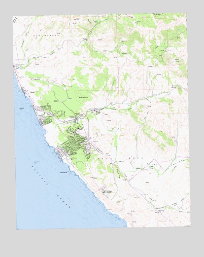
Cambria, CA USGS Topographic Map
Click on map above to begin viewing in our Map Viewer.

This topographic map contains these locations and features:
Feature Name Type Latitude Longitude GNIS ID View Map
Abalone CoveBayN35.5569°W121.1044°1872212View Map
Allied Arts GalleryBuildingN35.5627°W121.0930°1872213View Map
Bianchi QuarryMineN35.5792°W121.0478°2674941View Map
California Department of Forestry and Fire Protection Station 10 CambriaBuildingN35.5729°W121.1044°2664802View Map
CambriaPopulated PlaceN35.5641°W121.0807°1652683View Map
Cambria Air Force Station (historical)MilitaryN35.5225°W121.0625°2086560View Map
Cambria Branch San Luis Obispo City-County LibraryBuildingN35.5627°W121.0932°1872215View Map
Cambria CemeteryCemeteryN35.5757°W121.0990°240059View Map
Cambria Census Designated PlaceCensusN35.5525°W121.0845°2407941View Map
Cambria Chamber of CommerceBuildingN35.5675°W121.0999°1872216View Map
Cambria Community Day SchoolSchoolN35.5684°W121.0677°2518373View Map
Cambria Community Healthcare DistrictBuildingN35.5661°W121.0795°2665556View Map
Cambria Community Service CenterBuildingN35.5639°W121.0813°1872217View Map
Cambria Fire DepartmentBuildingN35.5573°W121.0811°2664518View Map
Cambria Grammar SchoolSchoolN35.5542°W121.0713°1872218View Map
Cambria PinesPopulated PlaceN35.5675°W121.0941°1703074View Map
Cambria PitMineN35.5353°W121.0564°2675141View Map
Cambria Post OfficePost OfficeN35.5639°W121.0813°1872219View Map
Cambria RockIslandN35.5702°W121.1224°240061View Map
Cambria Schoolhouse (historical)SchoolN35.5627°W121.0930°1872220View Map
Camp Ocean PinesLocaleN35.5416°W121.0830°1872221View Map
Camp YeagerLocaleN35.5736°W121.1021°1872222View Map
Coast Union High SchoolSchoolN35.5684°W121.0677°240733View Map
Crows NestLocaleN35.6022°W121.0502°1667663View Map
East VillagePopulated PlaceN35.5664°W121.0788°1872225View Map
Estrada RidgeRidgeN35.5319°W121.0527°252174View Map
Green ValleyValleyN35.5316°W121.0449°243000View Map
Green Valley CreekStreamN35.5327°W121.0491°243002View Map
Happy HillPopulated PlaceN35.5711°W121.1066°1872227View Map
HarmonyPopulated PlaceN35.5086°W121.0227°252898View Map
Harmony ValleyValleyN35.5194°W121.0355°243233View Map
Hearst San Simeon State ParkParkN35.5903°W121.0717°2612169View Map
Home School (historical)SchoolN35.6014°W121.1082°1667671View Map
KOTR-FM (Cambria)TowerN35.5239°W121.0621°1662825View Map
Leffingwell CoveBayN35.5750°W121.1146°1703081View Map
Leffingwell CreekStreamN35.5814°W121.1188°244714View Map
Leffingwell High SchoolSchoolN35.5689°W121.0727°2518346View Map
Leffingwell LandingLocaleN35.5808°W121.1191°1667674View Map
LeimertPopulated PlaceN35.5741°W121.1069°1872229View Map
Lodge HillPopulated PlaceN35.5511°W121.0807°1872230View Map
Marine TerracePopulated PlaceN35.5452°W121.0935°1872231View Map
Moonstone BeachBeachN35.5750°W121.1138°1703082View Map
North Coast DivisionCivilN35.5351°W121.0332°1935221View Map
Oceanie MineMineN35.5855°W121.0005°246813View Map
Old Santa Rosa Catholic ChurchChurchN35.5661°W121.0813°1872234View Map
Olmstead School (historical)SchoolN35.5397°W121.0027°1667678View Map
Palmer FlatsFlatN35.6100°W121.0741°247150View Map
Park HillPopulated PlaceN35.5639°W121.1049°1872235View Map
Perry CreekStreamN35.5650°W121.0746°247397View Map
Porta SuelaSummitN35.5033°W121.0307°1667680View Map
Rancho San Simeon AirportAirportN35.6080°W121.1102°1653310View Map
Rioly RunStreamN35.6169°W121.0674°248223View Map
San SimeonCivilN35.6133°W121.1044°248965View Map
San Simeon Beach State Park (historical)ParkN35.5836°W121.1216°248968View Map
San Simeon Natural PreserveReserveN35.5931°W121.1138°2741324View Map
San Simeon School (historical)SchoolN35.6247°W121.0557°1667683View Map
Santa Lucia Middle SchoolSchoolN35.5603°W121.0763°1872238View Map
Santa RosaCivilN35.5405°W121.0530°249103View Map
Santa Rosa CemeteryCemeteryN35.5659°W121.0810°249106View Map
Santa Rosa CreekStreamN35.5689°W121.1110°249108View Map
Santa Rosa Creek Natural PreserveReserveN35.5677°W121.1084°2741325View Map
Santa Rosa School (historical)SchoolN35.5744°W121.0402°1667684View Map
Scott RockSummitN35.5766°W121.0735°249222View Map
Shamel County ParkParkN35.5658°W121.1085°1703087View Map
South Fork San Simeon CreekStreamN35.6250°W121.0241°249718View Map
Steiner CreekStreamN35.6091°W121.0730°249905View Map
Swallow RockPillarN35.5241°W121.0616°1667685View Map
Tin CityPopulated PlaceN35.5636°W121.0782°1872244View Map
Van Gordon CreekStreamN35.5944°W121.1205°250939View Map
Vineyard ChurchChurchN35.5658°W121.0821°1872247View Map
Von Helm RockBarN35.5389°W121.1121°251115View Map
West VillagePopulated PlaceN35.5680°W121.0996°1872248View Map
White RockIslandN35.5330°W121.0880°251483View Map

Note: Coordinates in the location and feature list above are referenced to NAD83 datum.


Copyright (C) 2008-2024 Ryan Niemi / Sunset Dynamics ... All Rights Reserved