TopoQuest Logo
Do you find TopoQuest useful?
Help keep TopoQuest running and adding new maps/features by donating!
Bitcoin:  19c7KJd3qBynnjoSw5npx9KScwjBe4ifkT
Litecoin:  LXs6TkuXGGXo1vDsWCkWVdjQX94eUKd6ui
Home View Maps Find Maps Find Places Resources & Links


Pebblestone Shut-in, California Topographic Map

USGS Map Title: Pebblestone Shut-in, CA
USGS Map MRC: 35121F1
DRG (GeoTIFF) Download: o35121f1.tif


Neighboring USGS Topographic Map Quads:


  Burnett Peak, CA  
35121G2
 

  Bryson, CA  
35121G1
 

  Tierra Redonda Mountain, CA  
35120G8
 

  San Simeon, CA  
35121F2
 

  Pebblestone Shut-in, CA  
35121F1
 

  Lime Mountain, CA  
35120F8
 

  Pico Creek, CA  
35121E2
 

  Cambria, CA  
35121E1
 

  Cypress Mountain, CA  
35120E8


Map MRC Location:

N36°
W122°
N36°
W121°
H8 H7 H6 H5 H4 H3 H2 H1
G8 G7 G6 G5 G4 G3 G2 G1
F8 F7 F6 F5 F4 F3 F2 F1
E8 E7 E6 E5 E4 E3 E2 E1
D8 D7 D6 D5 D4 D3 D2 D1
C8 C7 C6 C5 C4 C3 C2 C1
B8 B7 B6 B5 B4 B3 B2 B1
A8 A7 A6 A5 A4 A3 A2 A1
N35°
W122°
N35°
W121°

Pebblestone Shut-in, CA USGS 1:24K Topographic Map Preview:
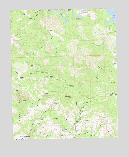
Pebblestone Shut-in, CA USGS Topographic Map
Click on map above to begin viewing in our Map Viewer.

This topographic map contains these locations and features:
Feature Name Type Latitude Longitude GNIS ID View Map
Almaden FlatsFlatN35.6850°W121.0807°238541View Map
Almaden MineMineN35.6850°W121.0816°238542View Map
Black Oak MountainSummitN35.6730°W121.1160°239437View Map
Buckeye MineMineN35.6908°W121.0866°239766View Map
Caballada CreekStreamN35.7450°W121.0955°239949View Map
Carrol CanyonValleyN35.6755°W121.0121°240280View Map
Deer FlatFlatN35.6961°W121.0019°241368View Map
Eagle RockSummitN35.6666°W121.0074°1660576View Map
Eucalyptus Lateral TenMineN35.6333°W121.0619°240060View Map
Goat Camp (historical)LocaleN35.6564°W121.0421°1667669View Map
Gould CreekStreamN35.7480°W121.0794°271375View Map
Grizzly BendBendN35.7455°W121.0552°243048View Map
Hamilton MineMineN35.6414°W121.0482°243148View Map
Kavanaugh CreekStreamN35.7486°W121.0019°244205View Map
Keystone MineMineN35.6597°W121.0757°244292View Map
Little Burnett CreekStreamN35.7480°W121.0716°272072View Map
Marmo-lejo FlatsFlatN35.6839°W121.1160°245543View Map
McLaughlin CanyonValleyN35.6841°W121.0007°245713View Map
Middle RidgeRidgeN35.6539°W121.1016°245877View Map
North Fork San Simeon CreekStreamN35.6269°W121.0532°246622View Map
North Grizzly Bend CreekStreamN35.7500°W121.0527°246628View Map
Ocean View MineMineN35.6980°W121.0944°246807View Map
Pebblestone Shut-inSummitN35.7464°W121.0413°1661207View Map
Pine MountainSummitN35.6900°W121.0944°247509View Map
Pine Mountain MineMineN35.6900°W121.0902°247511View Map
Quien Sabe MineMineN35.6705°W121.0796°247883View Map
Red MountainSummitN35.6436°W121.0741°248057View Map
Rocky ButteSummitN35.6652°W121.0594°248302View Map
Rocky Butte LookoutLocaleN35.6752°W121.0535°248303View Map
Tobacco CreekStreamN35.7430°W121.0969°250505View Map
Town SpringSpringN35.6788°W121.0090°250564View Map
Vulture RockSummitN35.6447°W121.0191°251120View Map

Note: Coordinates in the location and feature list above are referenced to NAD83 datum.


Copyright (C) 2008-2025 Ryan Niemi / Sunset Dynamics ... All Rights Reserved