TopoQuest Logo
Do you find TopoQuest useful?
Help keep TopoQuest running and adding new maps/features by donating!
Bitcoin:  19c7KJd3qBynnjoSw5npx9KScwjBe4ifkT
Litecoin:  LXs6TkuXGGXo1vDsWCkWVdjQX94eUKd6ui
Home View Maps Find Maps Find Places Resources & Links


Cameron, Illinois Topographic Map

USGS Map Title: Cameron, IL
USGS Map MRC: 40090H5
DRG (GeoTIFF) Download: o40090h5.tif


Neighboring USGS Topographic Map Quads:


  Little York, IL  
41090A6
 

  Alexis, IL  
41090A5
 

  North Henderson, IL  
41090A4
 

  Monmouth, IL  
40090H6
 

  Cameron, IL  
40090H5
 

  Galesburg West, IL  
40090H4
 

  Kirkwood East, IL  
40090G6
 

  Berwick, IL  
40090G5
 

  Abingdon, IL  
40090G4


Map MRC Location:

N41°
W91°
N41°
W90°
H8 H7 H6 H5 H4 H3 H2 H1
G8 G7 G6 G5 G4 G3 G2 G1
F8 F7 F6 F5 F4 F3 F2 F1
E8 E7 E6 E5 E4 E3 E2 E1
D8 D7 D6 D5 D4 D3 D2 D1
C8 C7 C6 C5 C4 C3 C2 C1
B8 B7 B6 B5 B4 B3 B2 B1
A8 A7 A6 A5 A4 A3 A2 A1
N40°
W91°
N40°
W90°

Cameron, IL USGS 1:24K Topographic Map Preview:
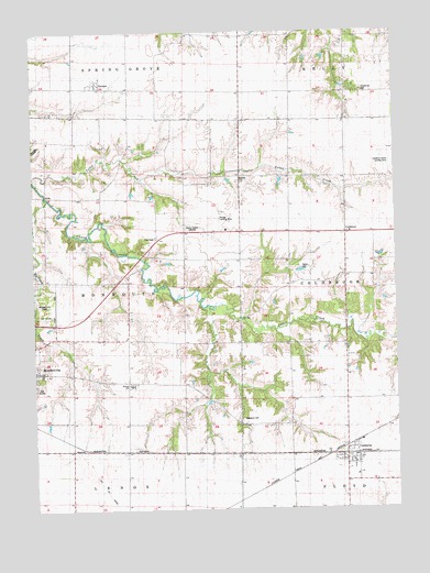
Cameron, IL USGS Topographic Map
Click on map above to begin viewing in our Map Viewer.

This topographic map contains these locations and features:
Feature Name Type Latitude Longitude GNIS ID View Map
CameronPopulated PlaceN40.8889°W90.5174°405427View Map
Cameron Fire DepartmentBuildingN40.8889°W90.5146°2640562View Map
Cameron Post OfficePost OfficeN40.8889°W90.5137°1823688View Map
Chapman School (historical)SchoolN40.9784°W90.5793°405976View Map
ColdbrookPopulated PlaceN40.9475°W90.5174°422568View Map
Coldbrook School (historical)SchoolN40.9023°W90.5357°406341View Map
Frymire School (historical)SchoolN40.9475°W90.5724°408786View Map
GerlawPopulated PlaceN40.9870°W90.6018°408963View Map
Gerlaw CemeteryCemeteryN40.9848°W90.5932°1975358View Map
Gerlaw Post OfficePost OfficeN40.9864°W90.6015°1823706View Map
Gibson Woods Golf CourseLocaleN40.9261°W90.6210°1823707View Map
Grier School (historical)SchoolN40.9111°W90.6129°409499View Map
Hawkins Farms Landing Strip (historical)AirportN40.9653°W90.5018°1719295View Map
Hazeldell School (historical)SchoolN40.9625°W90.6196°409990View Map
Hickory College (historical)SchoolN40.9028°W90.5729°410138View Map
Hillis School (historical)SchoolN40.8831°W90.5735°410282View Map
Lucas School (historical)SchoolN40.9470°W90.5326°412735View Map
Mosher CemeteryCemeteryN40.9614°W90.5543°1719307View Map
Ogden CemeteryCemeteryN40.9383°W90.5329°1719309View Map
Patterson CemeteryCemeteryN40.8990°W90.5535°1719310View Map
Science Hall School (historical)SchoolN40.9925°W90.5351°418122View Map
Scotchtown School (historical)SchoolN40.9198°W90.5532°418136View Map
Terpening CemeteryCemeteryN40.9842°W90.5107°1719327View Map
Township of MonmouthCivilN40.9346°W90.6124°429384View Map
Warren SchoolSchoolN40.9075°W90.5918°1719330View Map
Washington School (historical)SchoolN40.9350°W90.5935°420605View Map
WMOI-FM (Monmouth)TowerN40.8903°W90.6087°428243View Map
WRAM-AM (Monmouth)TowerN40.9498°W90.5721°428045View Map
Youngs Landing Strip (historical)AirportN40.9517°W90.5607°1719333View Map

Note: Coordinates in the location and feature list above are referenced to NAD83 datum.


Copyright (C) 2008-2025 Ryan Niemi / Sunset Dynamics ... All Rights Reserved