TopoQuest Logo
Do you find TopoQuest useful?
Help keep TopoQuest running and adding new maps/features by donating!
Bitcoin:  19c7KJd3qBynnjoSw5npx9KScwjBe4ifkT
Litecoin:  LXs6TkuXGGXo1vDsWCkWVdjQX94eUKd6ui
Home View Maps Find Maps Find Places Resources & Links


Camp Creek, Montana Topographic Map

USGS Map Title: Camp Creek, MT
USGS Map MRC: 46114G3
DRG (GeoTIFF) Download: o46114g3.tif


Neighboring USGS Topographic Map Quads:


  Petty Mountain, MT  
46114H4
 

  Diamond Point, MT  
46114H3
 

  Primrose, MT  
46114H2
 

  Garden Point, MT  
46114G4
 

  Camp Creek, MT  
46114G3
 

  Blue Mountain, MT  
46114G2
 

  West Fork Butte, MT  
46114F4
 

  Dick Creek, MT  
46114F3
 

  Carlton Lake, MT  
46114F2


Map MRC Location:

N47°
W115°
N47°
W114°
H8 H7 H6 H5 H4 H3 H2 H1
G8 G7 G6 G5 G4 G3 G2 G1
F8 F7 F6 F5 F4 F3 F2 F1
E8 E7 E6 E5 E4 E3 E2 E1
D8 D7 D6 D5 D4 D3 D2 D1
C8 C7 C6 C5 C4 C3 C2 C1
B8 B7 B6 B5 B4 B3 B2 B1
A8 A7 A6 A5 A4 A3 A2 A1
N46°
W115°
N46°
W114°

Camp Creek, MT USGS 1:24K Topographic Map Preview:
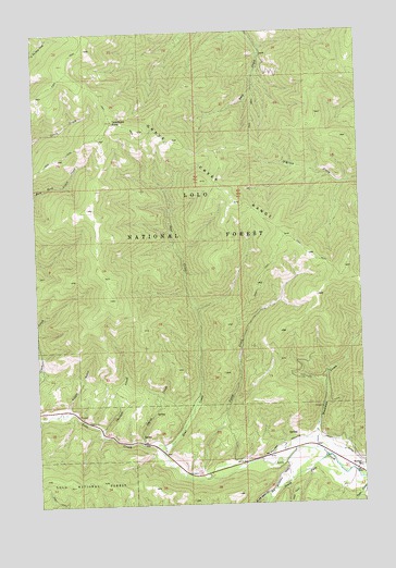
Camp Creek, MT USGS Topographic Map
Click on map above to begin viewing in our Map Viewer.

This topographic map contains these locations and features:
Feature Name Type Latitude Longitude GNIS ID View Map
Bear CreekStreamN46.7630°W114.3284°779483View Map
Camp CreekStreamN46.7571°W114.3107°780840View Map
Grave Creek RangeRangeN46.8358°W114.3118°784222View Map
Lawyers CombinationMineN46.7680°W114.2704°794288View Map
Lawyers Combination MineMineN46.7755°W114.2671°804850View Map
Lolo Creek MineMineN46.7680°W114.3412°804844View Map
Lolo DivisionCivilN46.8110°W114.3444°1940663View Map
Potato GulchValleyN46.7755°W114.3643°789135View Map
Schoolhouse GulchValleyN46.7608°W114.2501°776285View Map
SheldonMineN46.7733°W114.3448°794202View Map
Sheldon CreekStreamN46.7696°W114.3526°790381View Map
Sheldon MineMineN46.7724°W114.3487°804845View Map
Smith CreekStreamN46.7660°W114.3362°790710View Map
South Fork Lolo CreekStreamN46.7621°W114.2651°791005View Map
Telephone ButteSummitN46.8516°W114.3460°791946View Map
TriantlerMineN46.7733°W114.3590°794203View Map
Triantler MineMineN46.7741°W114.3607°804846View Map
Upper Lolo Creek MineMineN46.7699°W114.3423°804843View Map
Upper Triantler MineMineN46.7746°W114.3598°804847View Map
West Fork Butte CreekStreamN46.7527°W114.2882°792989View Map
Williams Preston Hovet DitchCanalN46.7669°W114.2712°793331View Map
Woodman CreekStreamN46.7641°W114.2696°793508View Map
Woodman MineMineN46.7583°W114.2507°794297View Map
Woodman Post Office (historical)Post OfficeN46.7652°W114.2676°1781221View Map
Woodman SchoolSchoolN46.7596°W114.2523°793509View Map

Note: Coordinates in the location and feature list above are referenced to NAD83 datum.


Copyright (C) 2008-2025 Ryan Niemi / Sunset Dynamics ... All Rights Reserved