TopoQuest Logo
Do you find TopoQuest useful?
Help keep TopoQuest running and adding new maps/features by donating!
Bitcoin:  19c7KJd3qBynnjoSw5npx9KScwjBe4ifkT
Litecoin:  LXs6TkuXGGXo1vDsWCkWVdjQX94eUKd6ui
Home View Maps Find Maps Find Places Resources & Links


Acord Lakes, Utah Topographic Map

USGS Map Title: Acord Lakes, UT
USGS Map MRC: 38111H4
DRG (GeoTIFF) Download: o38111h4.tif


Neighboring USGS Topographic Map Quads:


  Woods Lake, UT  
39111A5
 

  Heliotrope Mountain, UT  
39111A4
 

  Flagstaff Peak, UT  
39111A3
 

  Water Hollow Ridge, UT  
38111H5
 

  Acord Lakes, UT  
38111H4
 

  Emery West, UT  
38111H3
 

  Yogo Creek, UT  
38111G5
 

  Old Woman Plateau, UT  
38111G4
 

  Walker Flat, UT  
38111G3


Map MRC Location:

N39°
W112°
N39°
W111°
H8 H7 H6 H5 H4 H3 H2 H1
G8 G7 G6 G5 G4 G3 G2 G1
F8 F7 F6 F5 F4 F3 F2 F1
E8 E7 E6 E5 E4 E3 E2 E1
D8 D7 D6 D5 D4 D3 D2 D1
C8 C7 C6 C5 C4 C3 C2 C1
B8 B7 B6 B5 B4 B3 B2 B1
A8 A7 A6 A5 A4 A3 A2 A1
N38°
W112°
N38°
W111°

Acord Lakes, UT USGS 1:24K Topographic Map Preview:
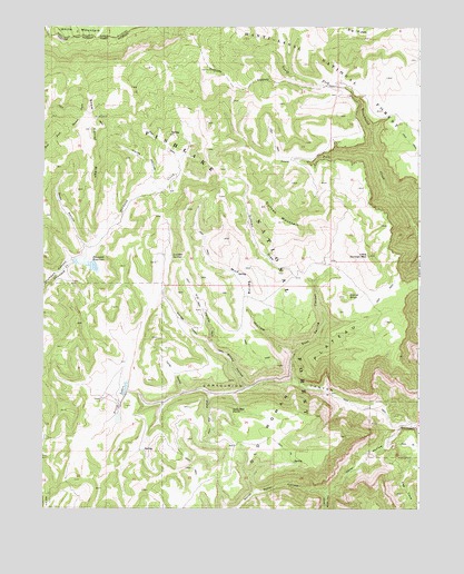
Acord Lakes, UT USGS Topographic Map
Click on map above to begin viewing in our Map Viewer.

This topographic map contains these locations and features:
Feature Name Type Latitude Longitude GNIS ID View Map
Acord LakesLakeN38.9063°W111.4726°1438121View Map
Anderson SpringSpringN38.9832°W111.4546°1449954View Map
Big RidgeRidgeN38.9997°W111.3868°1438726View Map
Broad HollowValleyN38.9064°W111.4327°1439136View Map
Collier HollowValleyN38.9055°W111.4535°1439894View Map
Convulsion CanyonValleyN38.8966°W111.3807°1439919View Map
Convulsion Coal MineMineN38.9152°W111.4168°1449983View Map
Corral KnollSummitN38.9300°W111.3993°1439978View Map
Duncan DrawValleyN38.9339°W111.4105°1440717View Map
Duncan Draw SpringSpringN38.9605°W111.4368°1449981View Map
Duncan MountainSummitN38.9539°W111.4263°1440719View Map
East Spring CanyonValleyN38.9091°W111.4171°1440848View Map
Eldridge HollowValleyN38.9161°W111.4430°1440888View Map
Fairy SpringSpringN38.9792°W111.4668°1449953View Map
Horse HollowValleyN38.9572°W111.4638°1441879View Map
Jack Adley MonumentPillarN38.9216°W111.4135°1451266View Map
Jolly Mill HollowValleyN38.9039°W111.4446°1442200View Map
Jolly Mill PointCapeN38.9011°W111.4377°1442201View Map
Little Duncan MountainSummitN38.9408°W111.3918°1442708View Map
Lizonbee Administrative SiteLocaleN38.9405°W111.4585°1451284View Map
Lizonbee SpringsSpringN38.9404°W111.4574°1442819View Map
Lower Horse Hollow SpringSpringN38.9695°W111.4758°1449952View Map
Lunds Cabin (historical)LocaleN38.9472°W111.3868°1448631View Map
Mud SpringSpringN38.9357°W111.4356°1449982View Map
Mud Spring HollowValleyN38.9152°W111.4168°1443716View Map
North Water HollowValleyN38.8794°W111.4052°1443989View Map
Pin HollowValleyN38.9158°W111.4432°1444356View Map
Road HollowValleyN38.9427°W111.4857°1445001View Map
Skutumpah DamDamN38.9389°W111.4899°1455088View Map
Skutumpah ReservoirReservoirN38.9391°W111.4894°1455087View Map
Skutumpah SpringSpringN38.9702°W111.4520°1455090View Map
Snow Corral RidgeRidgeN38.9697°W111.4830°1445740View Map
South Fork North Fork Quitchupah CreekStreamN38.9675°W111.3913°1445871View Map
South Water HollowValleyN38.8791°W111.4049°1445934View Map
The CoveBasinN38.8780°W111.3796°1446432View Map
Upper Horse Hollow SpringSpringN38.9726°W111.4802°1449951View Map
Water HollowValleyN38.8966°W111.3810°1447049View Map

Note: Coordinates in the location and feature list above are referenced to NAD83 datum.


Copyright (C) 2008-2024 Ryan Niemi / Sunset Dynamics ... All Rights Reserved