TopoQuest Logo
Do you find TopoQuest useful?
Help keep TopoQuest running and adding new maps/features by donating!
Bitcoin:  19c7KJd3qBynnjoSw5npx9KScwjBe4ifkT
Litecoin:  LXs6TkuXGGXo1vDsWCkWVdjQX94eUKd6ui
Home View Maps Find Maps Find Places Resources & Links


Heliotrope Mountain, Utah Topographic Map

USGS Map Title: Heliotrope Mountain, UT
USGS Map MRC: 39111A4
DRG (GeoTIFF) Download: o39111a4.tif


Neighboring USGS Topographic Map Quads:


  Black Mountain, UT  
39111B5
 

  Ferron Reservoir, UT  
39111B4
 

  Ferron Canyon, UT  
39111B3
 

  Woods Lake, UT  
39111A5
 

  Heliotrope Mountain, UT  
39111A4
 

  Flagstaff Peak, UT  
39111A3
 

  Water Hollow Ridge, UT  
38111H5
 

  Acord Lakes, UT  
38111H4
 

  Emery West, UT  
38111H3


Map MRC Location:

N40°
W112°
N40°
W111°
H8 H7 H6 H5 H4 H3 H2 H1
G8 G7 G6 G5 G4 G3 G2 G1
F8 F7 F6 F5 F4 F3 F2 F1
E8 E7 E6 E5 E4 E3 E2 E1
D8 D7 D6 D5 D4 D3 D2 D1
C8 C7 C6 C5 C4 C3 C2 C1
B8 B7 B6 B5 B4 B3 B2 B1
A8 A7 A6 A5 A4 A3 A2 A1
N39°
W112°
N39°
W111°

Heliotrope Mountain, UT USGS 1:24K Topographic Map Preview:
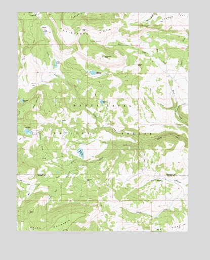
Heliotrope Mountain, UT USGS Topographic Map
Click on map above to begin viewing in our Map Viewer.

This topographic map contains these locations and features:
Feature Name Type Latitude Longitude GNIS ID View Map
Beaver CreekStreamN39.0483°W111.4255°1425379View Map
Black Fork CreekStreamN39.0391°W111.4482°1425661View Map
Black MountainSummitN39.0108°W111.4913°1425689View Map
Block MountainSummitN39.0702°W111.4880°1425772View Map
Brush DamDamN39.0733°W111.4391°1434725View Map
Brush ReservoirReservoirN39.0716°W111.4395°1426030View Map
Currant CreekStreamN39.0858°W111.3877°1427161View Map
Emerald LakeLakeN39.0744°W111.4975°1427814View Map
Emery DamDamN39.0933°W111.4724°1434729View Map
Emery ReservoirReservoirN39.0953°W111.4730°1427817View Map
Enos CreekStreamN39.0889°W111.3893°1427830View Map
Ferron MountainSummitN39.1225°W111.3907°1441031View Map
Fish CreekStreamN39.0394°W111.4482°1441073View Map
Harris KnollSummitN39.0952°W111.4132°1428549View Map
Heliotrope MountainSummitN39.1150°W111.4538°1428635View Map
Heliotrope PointSummitN39.0994°W111.4377°1428636View Map
Henningson DamDamN39.0566°W111.4907°1434723View Map
Henningson ReservoirReservoirN39.0566°W111.4931°1428660View Map
Horse HeavenBasinN39.1086°W111.4444°1428846View Map
Jason CreekStreamN39.0672°W111.3846°1442111View Map
Julius Flat DamDamN39.0475°W111.4557°1434721View Map
Julius Flat ReservoirReservoirN39.0451°W111.4545°1429261View Map
North Fork Muddy CreekStreamN39.0522°W111.4091°1430796View Map
Oleys LakesLakeN39.1130°W111.4809°1430995View Map
Peavine FlatFlatN39.0839°W111.4891°1431160View Map
Petes CreekStreamN39.0683°W111.3852°1431197View Map
Reservoir CreekStreamN39.0400°W111.4755°1431757View Map
Slide ForkStreamN39.0269°W111.4846°1445684View Map
South Fork Muddy CreekStreamN39.0522°W111.4091°1432696View Map
Spinners DamDamN39.0900°W111.4474°1434727View Map
Spinners ReservoirReservoirN39.0903°W111.4469°1432796View Map
Twelve Mile CampgroundLocaleN39.1230°W111.4877°1454928View Map
White MountainSummitN39.0030°W111.4688°1447263View Map
White Mountain CabinLocaleN39.0289°W111.4496°1434174View Map

Note: Coordinates in the location and feature list above are referenced to NAD83 datum.


Copyright (C) 2008-2025 Ryan Niemi / Sunset Dynamics ... All Rights Reserved