TopoQuest Logo
Do you find TopoQuest useful?
Help keep TopoQuest running and adding new maps/features by donating!
Bitcoin:  19c7KJd3qBynnjoSw5npx9KScwjBe4ifkT
Litecoin:  LXs6TkuXGGXo1vDsWCkWVdjQX94eUKd6ui
Home View Maps Find Maps Find Places Resources & Links


Adamson, Oklahoma Topographic Map

USGS Map Title: Adamson, OK
USGS Map MRC: 34095H5
DRG (GeoTIFF) Download: o34095h5.tif


Neighboring USGS Topographic Map Quads:


  Crowder, OK  
35095A6
 

  Blocker, OK  
35095A5
 

  Featherston, OK  
35095A4
 

  Krebs, OK  
34095H6
 

  Adamson, OK  
34095H5
 

  Gowen, OK  
34095H4
 

  Hartshorne SW, OK  
34095G6
 

  Hartshorne, OK  
34095G5
 

  Higgins, OK  
34095G4


Map MRC Location:

N35°
W96°
N35°
W95°
H8 H7 H6 H5 H4 H3 H2 H1
G8 G7 G6 G5 G4 G3 G2 G1
F8 F7 F6 F5 F4 F3 F2 F1
E8 E7 E6 E5 E4 E3 E2 E1
D8 D7 D6 D5 D4 D3 D2 D1
C8 C7 C6 C5 C4 C3 C2 C1
B8 B7 B6 B5 B4 B3 B2 B1
A8 A7 A6 A5 A4 A3 A2 A1
N34°
W96°
N34°
W95°

Adamson, OK USGS 1:24K Topographic Map Preview:
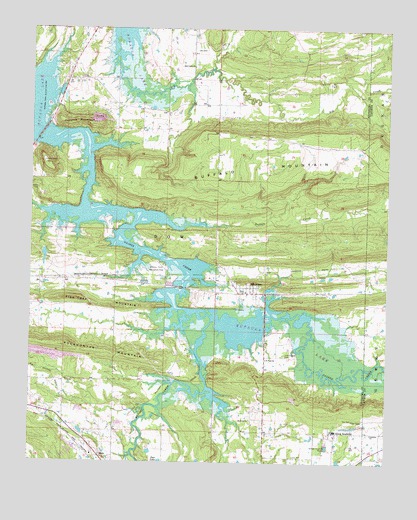
Adamson, OK USGS Topographic Map
Click on map above to begin viewing in our Map Viewer.

This topographic map contains these locations and features:
Feature Name Type Latitude Longitude GNIS ID View Map
AdamsonPopulated PlaceN34.9240°W95.5472°1089538View Map
Adamson CemeteryCemeteryN34.9259°W95.5445°2724238View Map
Ash CreekStreamN34.9920°W95.5964°1089727View Map
Ash Creek ChurchChurchN34.9893°W95.5689°1089728View Map
Brushy CreekStreamN34.9159°W95.5619°1090572View Map
Buffalo CreekStreamN34.9443°W95.5775°1090643View Map
Buffalo MountainSummitN34.9648°W95.5319°1090652View Map
Cambria ChurchChurchN34.8834°W95.5050°1090828View Map
Cole Chapel CemeteryCemeteryN34.9060°W95.5358°1091566View Map
Courts CemeteryCemeteryN34.9853°W95.5214°1091763View Map
Cyclone MountainSummitN34.9729°W95.6122°1091903View Map
DowPopulated PlaceN34.8768°W95.6003°1092175View Map
Elementary at Jones AcademySchoolN34.8844°W95.5179°1094257View Map
Eufala Wildlife Managment AreaReserveN34.9068°W95.5125°1763656View Map
Fish Trap MountainSummitN34.9223°W95.6092°1092839View Map
Gaines CreekStreamN34.9432°W95.5894°1093089View Map
Hickory Point Recreation AreaParkN34.9307°W95.5808°1093719View Map
Jones LakeReservoirN34.8751°W95.5153°1755528View Map
Jones Lake DamDamN34.8751°W95.5153°1755527View Map
Kemp CemeteryCemeteryN34.9537°W95.6230°1094320View Map
Mount Nebo ChurchChurchN34.8873°W95.5478°1095579View Map
Oknoname 121019 DamDamN34.9368°W95.6203°1751142View Map
Oknoname 121019 ReservoirReservoirN34.9368°W95.6203°1751143View Map
Oknoname 131007 ReservoirReservoirN34.9120°W95.5785°1751433View Map
Pocahontas MountainSummitN34.9087°W95.6133°1096790View Map
Saint Paul ChurchChurchN34.9048°W95.5425°1097640View Map
Union ChapelChurchN34.8873°W95.5080°1099157View Map

Note: Coordinates in the location and feature list above are referenced to NAD83 datum.


Copyright (C) 2008-2024 Ryan Niemi / Sunset Dynamics ... All Rights Reserved