TopoQuest Logo
Do you find TopoQuest useful?
Help keep TopoQuest running and adding new maps/features by donating!
Bitcoin:  19c7KJd3qBynnjoSw5npx9KScwjBe4ifkT
Litecoin:  LXs6TkuXGGXo1vDsWCkWVdjQX94eUKd6ui
Home View Maps Find Maps Find Places Resources & Links


Arney, Indiana Topographic Map

USGS Map Title: Arney, IN
USGS Map MRC: 39086B8
DRG (GeoTIFF) Download: o39086b8.tif


Neighboring USGS Topographic Map Quads:


  Clay City, IN  
39087C1
 

  Patricksburg, IN  
39086C8
 

  Spencer, IN  
39086C7
 

  Coal City, IN  
39087B1
 

  Arney, IN  
39086B8
 

  Freedom, IN  
39086B7
 

  Switz City, IN  
39087A1
 

  Bloomfield, IN  
39086A8
 

  Solsberry, IN  
39086A7


Map MRC Location:

N40°
W87°
N40°
W86°
H8 H7 H6 H5 H4 H3 H2 H1
G8 G7 G6 G5 G4 G3 G2 G1
F8 F7 F6 F5 F4 F3 F2 F1
E8 E7 E6 E5 E4 E3 E2 E1
D8 D7 D6 D5 D4 D3 D2 D1
C8 C7 C6 C5 C4 C3 C2 C1
B8 B7 B6 B5 B4 B3 B2 B1
A8 A7 A6 A5 A4 A3 A2 A1
N39°
W87°
N39°
W86°

Arney, IN USGS 1:24K Topographic Map Preview:
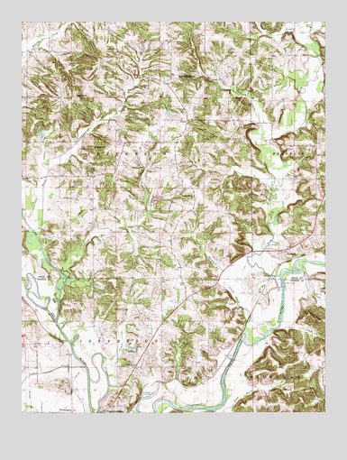
Arney, IN USGS Topographic Map
Click on map above to begin viewing in our Map Viewer.

This topographic map contains these locations and features:
Feature Name Type Latitude Longitude GNIS ID View Map
Antioch ChurchChurchN39.2412°W86.9611°430210View Map
ArneyPopulated PlaceN39.2187°W86.9317°430270View Map
Beech CreekStreamN39.1809°W86.9933°430714View Map
Brush CreekStreamN39.1681°W86.9814°431676View Map
Buckhall CreekStreamN39.1512°W86.9083°431746View Map
Corbin CreekStreamN39.1409°W86.9667°432960View Map
Dillon HillSummitN39.2095°W86.9678°433557View Map
Dutch Bethel ChurchChurchN39.2328°W86.9300°433815View Map
Dyer LakeReservoirN39.1453°W86.9544°447806View Map
Dyer Lake DamDamN39.1448°W86.9550°447807View Map
FarmersPopulated PlaceN39.1753°W86.8917°434398View Map
Farmers FerryCrossingN39.1664°W86.8928°434401View Map
Fish CreekStreamN39.1689°W86.8939°434507View Map
Goose CreekStreamN39.1259°W86.9214°435197View Map
Griffith CemeteryCemeteryN39.1399°W86.9526°435502View Map
Jack CreekStreamN39.1706°W86.8847°436875View Map
Jim CreekStreamN39.1506°W86.8975°437007View Map
Lemon CreekStreamN39.1395°W86.9742°437772View Map
Lick CreekStreamN39.1542°W86.9856°437863View Map
Mack CreekStreamN39.2125°W86.9014°438459View Map
Need HillSummitN39.2256°W86.9761°439968View Map
Oak Grove CemeteryCemeteryN39.1673°W86.9428°440405View Map
Pleasant Bethel ChurchChurchN39.1939°W86.9292°441235View Map
Point CommercePopulated PlaceN39.1253°W86.9653°441389View Map
Salter LakeReservoirN39.1935°W86.9446°448780View Map
Salter Lake DamDamN39.1923°W86.9467°448779View Map
Township of JeffersonCivilN39.1317°W86.9806°453485View Map
Township of JeffersonCivilN39.2114°W86.9800°453494View Map
Von Sloughs Airport (historical)AirportN39.1967°W86.9925°449124View Map
West Fork CreekStreamN39.2428°W86.8831°445745View Map
Williams CemeteryCemeteryN39.1678°W86.9200°446063View Map
WorthingtonPopulated PlaceN39.1250°W86.9795°446331View Map

Note: Coordinates in the location and feature list above are referenced to NAD83 datum.


Copyright (C) 2008-2025 Ryan Niemi / Sunset Dynamics ... All Rights Reserved