TopoQuest Logo
Do you find TopoQuest useful?
Help keep TopoQuest running and adding new maps/features by donating!
Bitcoin:  19c7KJd3qBynnjoSw5npx9KScwjBe4ifkT
Litecoin:  LXs6TkuXGGXo1vDsWCkWVdjQX94eUKd6ui
Home View Maps Find Maps Find Places Resources & Links


Clay City, Indiana Topographic Map

USGS Map Title: Clay City, IN
USGS Map MRC: 39087C1
DRG (GeoTIFF) Download: o39087c1.tif


Neighboring USGS Topographic Map Quads:


  Staunton, IN  
39087D2
 

  Center Point, IN  
39087D1
 

  Poland, IN  
39086D8
 

  Saline City, IN  
39087C2
 

  Clay City, IN  
39087C1
 

  Patricksburg, IN  
39086C8
 

  Jasonville, IN  
39087B2
 

  Coal City, IN  
39087B1
 

  Arney, IN  
39086B8


Map MRC Location:

N40°
W88°
N40°
W87°
H8 H7 H6 H5 H4 H3 H2 H1
G8 G7 G6 G5 G4 G3 G2 G1
F8 F7 F6 F5 F4 F3 F2 F1
E8 E7 E6 E5 E4 E3 E2 E1
D8 D7 D6 D5 D4 D3 D2 D1
C8 C7 C6 C5 C4 C3 C2 C1
B8 B7 B6 B5 B4 B3 B2 B1
A8 A7 A6 A5 A4 A3 A2 A1
N39°
W88°
N39°
W87°

Clay City, IN USGS 1:24K Topographic Map Preview:
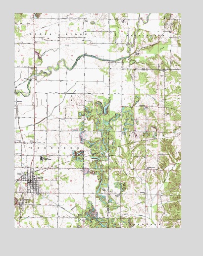
Clay City, IN USGS Topographic Map
Click on map above to begin viewing in our Map Viewer.

This topographic map contains these locations and features:
Feature Name Type Latitude Longitude GNIS ID View Map
Barrick CornerPopulated PlaceN39.2562°W87.0733°430536View Map
Beech ChurchChurchN39.2698°W87.0453°430713View Map
Booe AirportAirportN39.2731°W87.1222°2677049View Map
Burger CemeteryCemeteryN39.3028°W87.0078°431831View Map
Clay CityPopulated PlaceN39.2767°W87.1128°432585View Map
Clay City - Harrison Township Volunteer Fire DepartmentBuildingN39.2773°W87.1171°2626059View Map
Clay City Police DepartmentBuildingN39.2763°W87.1133°2758192View Map
Cole CemeteryCemeteryN39.3211°W87.0725°432753View Map
DanvillePopulated PlaceN39.2645°W87.0911°452126View Map
DenmarkPopulated PlaceN39.2698°W87.0258°433472View Map
Eel RiverPopulated PlaceN39.3234°W87.1236°434035View Map
Fairview CemeteryCemeteryN39.3689°W87.0081°434318View Map
Fatch ChapelChurchN39.3714°W87.0722°434418View Map
Feederdam BridgeBridgeN39.3364°W87.1133°434430View Map
Funk CemeteryCemeteryN39.3445°W87.0008°434902View Map
Goshorn Memorial ParkCemeteryN39.2823°W87.1189°435233View Map
Greenwell CemeteryCemeteryN39.2998°W87.1214°435461View Map
Happy HollowValleyN39.2800°W87.0354°435709View Map
Harris CemeteryCemeteryN39.3434°W87.1131°435778View Map
Hickory CornerPopulated PlaceN39.3050°W87.0445°436098View Map
Hog CreekStreamN39.3725°W87.0311°436286View Map
Lenning BranchStreamN39.2553°W87.0225°437777View Map
Letsinger DitchCanalN39.2523°W87.0942°437793View Map
Liechty CemeteryCemeteryN39.2839°W87.0722°437876View Map
Maple Grove CemeteryCemeteryN39.2931°W87.1247°438549View Map
Maple Grove ChurchChurchN39.3578°W87.1097°438557View Map
Marion CemeteryCemeteryN39.2967°W87.0056°438612View Map
Mast CemeteryCemeteryN39.3164°W87.0103°438705View Map
MiddleburyPopulated PlaceN39.2642°W87.1189°439112View Map
Otterbein ChurchChurchN39.3423°W87.0122°440754View Map
Pleasant View ChurchChurchN39.2848°W87.0250°441342View Map
Red Brush CemeteryCemeteryN39.2623°W87.0453°441818View Map
Saint Peters ChurchChurchN39.2928°W87.0542°442813View Map
Shelkett DitchCanalN39.3695°W87.0631°443351View Map
Sixmile CreekStreamN39.3500°W87.0383°443566View Map
SmithvillePopulated PlaceN39.3209°W87.0258°443709View Map
Stephens CemeteryCemeteryN39.3381°W87.0145°444126View Map
Sulphur CreekStreamN39.3453°W87.0378°444373View Map
Swalley ChapelChurchN39.3520°W87.0339°444452View Map
Town of Clay CityCivilN39.2769°W87.1127°2396650View Map
Township of HarrisonCivilN39.2653°W87.1094°453381View Map
Turkey CreekStreamN39.3387°W87.1086°444961View Map
Union ChapelChurchN39.2998°W87.1106°445084View Map
Wabash Camp GroundLocaleN39.2906°W87.1033°452276View Map
West Fork Lick CreekStreamN39.2553°W87.0211°445754View Map
Zenor CemeteryCemeteryN39.3681°W87.0117°446434View Map

Note: Coordinates in the location and feature list above are referenced to NAD83 datum.


Copyright (C) 2008-2025 Ryan Niemi / Sunset Dynamics ... All Rights Reserved