TopoQuest Logo
Do you find TopoQuest useful?
Help keep TopoQuest running and adding new maps/features by donating!
Bitcoin:  19c7KJd3qBynnjoSw5npx9KScwjBe4ifkT
Litecoin:  LXs6TkuXGGXo1vDsWCkWVdjQX94eUKd6ui
Home View Maps Find Maps Find Places Resources & Links


Athens, Louisiana Topographic Map

USGS Map Title: Athens, LA
USGS Map MRC: 32093F1
DRG (GeoTIFF) Download: o32093f1.tif


Neighboring USGS Topographic Map Quads:


  Blackburn, LA  
32093G2
 

  Homer, LA  
32093G1
 

  Arizona, LA  
32092G8
 

  Langston, LA  
32093F2
 

  Athens, LA  
32093F1
 

  Marsalis, LA  
32092F8
 

  Ada, LA  
32093E2
 

  Gibsland, LA  
32093E1
 

  Arcadia, LA  
32092E8


Map MRC Location:

N33°
W94°
N33°
W93°
H8 H7 H6 H5 H4 H3 H2 H1
G8 G7 G6 G5 G4 G3 G2 G1
F8 F7 F6 F5 F4 F3 F2 F1
E8 E7 E6 E5 E4 E3 E2 E1
D8 D7 D6 D5 D4 D3 D2 D1
C8 C7 C6 C5 C4 C3 C2 C1
B8 B7 B6 B5 B4 B3 B2 B1
A8 A7 A6 A5 A4 A3 A2 A1
N32°
W94°
N32°
W93°

Athens, LA USGS 1:24K Topographic Map Preview:
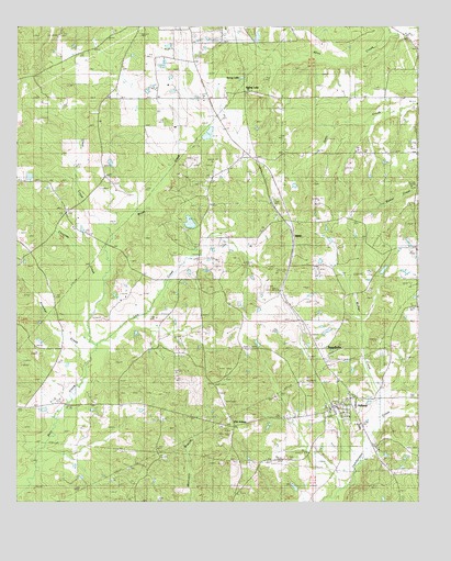
Athens, LA USGS Topographic Map
Click on map above to begin viewing in our Map Viewer.

This topographic map contains these locations and features:
Feature Name Type Latitude Longitude GNIS ID View Map
AthensPopulated PlaceN32.6504°W93.0257°532240View Map
Athens Elementary SchoolSchoolN32.6504°W93.0199°544116View Map
Athens Gas FieldOilfieldN32.6813°W93.0238°553321View Map
Athens High SchoolSchoolN32.6450°W93.0189°544117View Map
Athens Lookout TowerTowerN32.6599°W93.0596°558733View Map
Athens Post OfficePost OfficeN32.6507°W93.0257°1630067View Map
Atkins CemeteryCemeteryN32.6790°W93.0416°532242View Map
Brush CreekStreamN32.6665°W93.1004°533450View Map
Choctaw CreekStreamN32.6782°W93.1024°547216View Map
Claiborne Parish Fire Protection District 5BuildingN32.6517°W93.0209°2673087View Map
Clear CreekStreamN32.6957°W93.0957°533982View Map
Cooksey CemeteryCemeteryN32.7089°W93.0947°534098View Map
Frincher CreekStreamN32.6632°W93.1029°547383View Map
Kimbel SchoolSchoolN32.7054°W93.1121°536188View Map
Kimbell CemeteryCemeteryN32.7010°W93.1090°544139View Map
Leatherman Creek Oil and Gas FieldOilfieldN32.6288°W93.1018°544140View Map
Lick CreekStreamN32.6668°W93.1004°536441View Map
Lower Old Athens CemeteryCemeteryN32.6448°W93.0603°544143View Map
Mount Paron CemeteryCemeteryN32.6907°W93.1218°549413View Map
Mount Paron Primitive Baptist ChurchChurchN32.6913°W93.1218°555403View Map
Mount Piller ChurchChurchN32.7310°W93.0691°537383View Map
Mount Supeal SchoolSchoolN32.7160°W93.0566°537406View Map
Mount Superior ChurchChurchN32.7101°W93.0479°537407View Map
MT OLIVE CHRISTIAN SCHOOLSchoolN32.6501°W93.0199°547753View Map
MulnixPopulated PlaceN32.6946°W93.0391°541147View Map
Old AthensPopulated PlaceN32.6457°W93.0577°541159View Map
Old Athens CemeteryCemeteryN32.6465°W93.0593°544162View Map
Parish Governing Authority District 10CivilN32.7472°W93.0408°1929778View Map
Parish Governing Authority District 5CivilN32.6555°W93.0831°1930071View Map
Pleasant Valley SchoolSchoolN32.6521°W93.0868°538267View Map
RussellvillePopulated PlaceN32.6660°W93.0288°556564View Map
Saint Johns ChurchChurchN32.7185°W93.0007°538899View Map
Salem CemeteryCemeteryN32.6593°W93.0260°539092View Map
Sanctified ChurchChurchN32.6332°W93.0002°539127View Map
Sandy CreekStreamN32.7485°W93.0104°547965View Map
Spring LakePopulated PlaceN32.7335°W93.0552°541195View Map
Spring LakeLakeN32.7366°W93.0553°556123View Map
Village of AthensCivilN32.6513°W93.0254°2407411View Map
Walker CreekStreamN32.6477°W93.0129°540199View Map
Ward FiveCivilN32.6468°W93.0477°544985View Map

Note: Coordinates in the location and feature list above are referenced to NAD83 datum.


Copyright (C) 2008-2025 Ryan Niemi / Sunset Dynamics ... All Rights Reserved