TopoQuest Logo
Do you find TopoQuest useful?
Help keep TopoQuest running and adding new maps/features by donating!
Bitcoin:  19c7KJd3qBynnjoSw5npx9KScwjBe4ifkT
Litecoin:  LXs6TkuXGGXo1vDsWCkWVdjQX94eUKd6ui
Home View Maps Find Maps Find Places Resources & Links


Arcadia, Louisiana Topographic Map

USGS Map Title: Arcadia, LA
USGS Map MRC: 32092E8
DRG (GeoTIFF) Download: o32092e8.tif


Neighboring USGS Topographic Map Quads:


  Athens, LA  
32093F1
 

  Marsalis, LA  
32092F8
 

  Lake Foursome, LA  
32092F7
 

  Gibsland, LA  
32093E1
 

  Arcadia, LA  
32092E8
 

  Simsboro, LA  
32092E7
 

  Sailes, LA  
32093D1
 

  Bryceland, LA  
32092D8
 

  Wilson Creek, LA  
32092D7


Map MRC Location:

N33°
W93°
N33°
W92°
H8 H7 H6 H5 H4 H3 H2 H1
G8 G7 G6 G5 G4 G3 G2 G1
F8 F7 F6 F5 F4 F3 F2 F1
E8 E7 E6 E5 E4 E3 E2 E1
D8 D7 D6 D5 D4 D3 D2 D1
C8 C7 C6 C5 C4 C3 C2 C1
B8 B7 B6 B5 B4 B3 B2 B1
A8 A7 A6 A5 A4 A3 A2 A1
N32°
W93°
N32°
W92°

Arcadia, LA USGS 1:24K Topographic Map Preview:
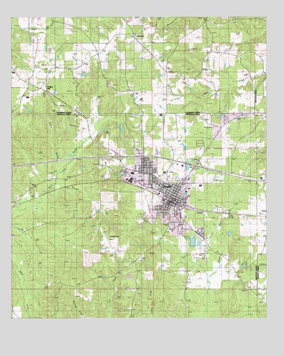
Arcadia, LA USGS Topographic Map
Click on map above to begin viewing in our Map Viewer.

This topographic map contains these locations and features:
Feature Name Type Latitude Longitude GNIS ID View Map
Alabama Baptist ChurchChurchN32.5849°W92.8810°553273View Map
ArcadiaPopulated PlaceN32.5490°W92.9202°1629912View Map
Arcadia Baptist ChurchChurchN32.5490°W92.9199°549059View Map
Arcadia Fire DepartmentBuildingN32.5497°W92.9207°2673047View Map
Arcadia High SchoolSchoolN32.5552°W92.9076°549061View Map
Arcadia Police DepartmentBuildingN32.5475°W92.9215°2755260View Map
Arcadia Post OfficePost OfficeN32.5485°W92.9218°1630954View Map
Arcadia-Bienville Parish AirportAirportN32.5297°W92.9501°1632605View Map
Arcardia Gas FieldOilfieldN32.5085°W92.9168°549060View Map
Bienville General Hospital (historical)HospitalN32.5538°W92.9132°549064View Map
Bienville Medical CenterHospitalN32.5531°W92.9147°2674134View Map
Bienville Parish Sheriff's OfficeBuildingN32.5470°W92.9255°2755205View Map
Boggy BranchStreamN32.5607°W92.9757°533294View Map
Brice CemeteryCemeteryN32.5607°W92.9810°533386View Map
Bridges MillPopulated PlaceN32.5946°W92.9829°540984View Map
Brinsons CreekStreamN32.5454°W92.9910°533409View Map
Butler CemeteryCemeteryN32.5193°W92.9096°533587View Map
Butler PondLakeN32.5243°W92.9439°553844View Map
Camp WawbanseeLocaleN32.5210°W92.8824°549069View Map
Crawford Elementary SchoolSchoolN32.5557°W92.9121°549073View Map
FordsPopulated PlaceN32.5482°W92.9954°543212View Map
Givens-McGuire CemeteryCemeteryN32.5190°W92.8877°535238View Map
Hebron ChurchChurchN32.5296°W92.9315°535610View Map
Hebron SchoolSchoolN32.5360°W92.9215°535611View Map
Hopewell SchoolSchoolN32.6140°W92.9021°535794View Map
HurricanePopulated PlaceN32.6177°W92.9402°554807View Map
Hurricane CemeteryCemeteryN32.6170°W92.9412°544138View Map
Hurricane SchoolSchoolN32.5938°W92.9393°535883View Map
Interchange 67CrossingN32.5671°W92.9477°541479View Map
Interchange 69CrossingN32.5635°W92.9102°541480View Map
KWQN-FM (Arcadia)TowerN32.5138°W92.9835°1633032View Map
Macedonia CemeteryCemeteryN32.6232°W92.8921°544145View Map
Macedonia ChurchChurchN32.6235°W92.8932°536799View Map
Moore CemeteryCemeteryN32.5974°W92.9685°537193View Map
Mount Calvary CemeteryCemeteryN32.5679°W92.9522°2776786View Map
Mount Moriah ChurchChurchN32.5849°W92.9668°537338View Map
North Bienville Fire Protection District Station 4BuildingN32.5485°W92.9226°2672854View Map
North Bienville Fire Protection District Station 8BuildingN32.5799°W92.9006°2672871View Map
Old Mount Calm CemeteryCemeteryN32.5679°W92.9518°2774678View Map
Town of ArcadiaCivilN32.5506°W92.9218°2405160View Map
Ward TwoCivilN32.5502°W92.9418°544930View Map
West Arcadia Gas FieldOilfieldN32.5415°W92.9996°549501View Map

Note: Coordinates in the location and feature list above are referenced to NAD83 datum.


Copyright (C) 2008-2025 Ryan Niemi / Sunset Dynamics ... All Rights Reserved