TopoQuest Logo
Do you find TopoQuest useful?
Help keep TopoQuest running and adding new maps/features by donating!
Bitcoin:  19c7KJd3qBynnjoSw5npx9KScwjBe4ifkT
Litecoin:  LXs6TkuXGGXo1vDsWCkWVdjQX94eUKd6ui
Home View Maps Find Maps Find Places Resources & Links


Baker Hill, Alabama Topographic Map

USGS Map Title: Baker Hill, AL
USGS Map MRC: 31085G3
DRG (GeoTIFF) Download: o31085g3.tif


Neighboring USGS Topographic Map Quads:


  Clayton North, AL  
31085H4
 

  White Oak, AL  
31085H3
 

  Eufaula North, AL  
31085H2
 

  Clayton South, AL  
31085G4
 

  Baker Hill, AL  
31085G3
 

  Eufaula South, AL  
31085G2
 

  Texasville, AL  
31085F4
 

  Lawrenceville, AL  
31085F3
 

  Fort Gaines NW, AL  
31085F2


Map MRC Location:

N32°
W86°
N32°
W85°
H8 H7 H6 H5 H4 H3 H2 H1
G8 G7 G6 G5 G4 G3 G2 G1
F8 F7 F6 F5 F4 F3 F2 F1
E8 E7 E6 E5 E4 E3 E2 E1
D8 D7 D6 D5 D4 D3 D2 D1
C8 C7 C6 C5 C4 C3 C2 C1
B8 B7 B6 B5 B4 B3 B2 B1
A8 A7 A6 A5 A4 A3 A2 A1
N31°
W86°
N31°
W85°

Baker Hill, AL USGS 1:24K Topographic Map Preview:
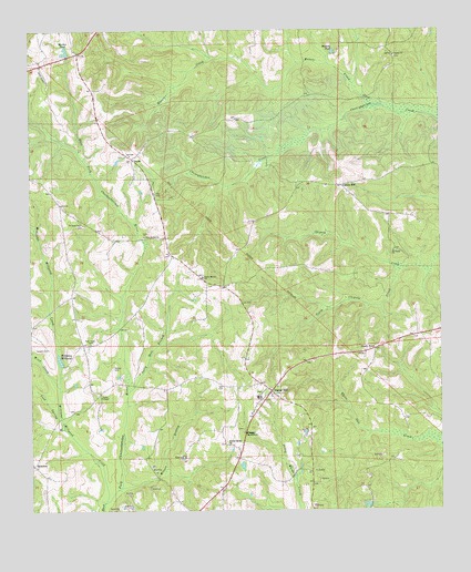
Baker Hill, AL USGS Topographic Map
Click on map above to begin viewing in our Map Viewer.

This topographic map contains these locations and features:
Feature Name Type Latitude Longitude GNIS ID View Map
Baker HillPopulated PlaceN31.7813°W85.3022°154970View Map
Baker Hill Post OfficePost OfficeN31.7810°W85.3019°168046View Map
Baker Hill SchoolSchoolN31.7796°W85.3063°155355View Map
Baker Hill Volunteer Fire DepartmentBuildingN31.7738°W85.3076°2691565View Map
Bakerhill DivisionCivilN31.7736°W85.2856°165654View Map
Belcher Bethel Baptist ChurchChurchN31.7674°W85.3149°155851View Map
Belcher Number 1 MineMineN31.7716°W85.2930°163586View Map
Bentons PondReservoirN31.8695°W85.2822°113940View Map
Cold Spring BranchStreamN31.7713°W85.3647°116395View Map
Cotton HillPopulated PlaceN31.8346°W85.2805°156217View Map
Farmers Gin (historical)LocaleN31.7824°W85.3399°1805321View Map
Farrior BranchStreamN31.8235°W85.3738°118211View Map
GainoPopulated PlaceN31.8413°W85.3441°156389View Map
Houstons Store (historical)LocaleN31.8168°W85.3316°134793View Map
Howell CreekStreamN31.8554°W85.2699°120483View Map
Johnstons Store (historical)LocaleN31.7910°W85.3588°134796View Map
Lewis ChapelChurchN31.7799°W85.3535°152026View Map
Martin PondReservoirN31.8690°W85.3642°122337View Map
Mount Aerial ChurchChurchN31.8177°W85.2644°123137View Map
New Bethel ChurchChurchN31.8216°W85.3408°152601View Map
New Hope CemeteryCemeteryN31.7938°W85.3569°123787View Map
OatestonPopulated PlaceN31.7621°W85.3744°156821View Map
Peggy BottomBendN31.7704°W85.3099°124570View Map
Richard Number 1 MineMineN31.7652°W85.2944°163589View Map
Rocky Mount ChurchChurchN31.8110°W85.3233°125867View Map
Saint Pauls ChurchChurchN31.8249°W85.3597°153289View Map
Sally Hole BranchStreamN31.7813°W85.3452°126259View Map
Sandy PointPopulated PlaceN31.7921°W85.2699°157014View Map
Sardis CemeteryCemeteryN31.8679°W85.2633°163355View Map
Sardis ChurchChurchN31.8685°W85.2638°126408View Map
Scotch CemeteryCemeteryN31.7924°W85.3691°126472View Map
South Chipola CreekStreamN31.8124°W85.2627°155247View Map
Stewarts Gin (historical)LocaleN31.8674°W85.3666°1805353View Map
Town of BakerhillCivilN31.7769°W85.2954°2405200View Map
Walker CemeteryCemeteryN31.7874°W85.3499°128506View Map
Williams MillpondReservoirN31.7895°W85.3662°129028View Map
Williams Millpond CreekStreamN31.7524°W85.3527°153998View Map
Wilson BranchStreamN31.7563°W85.3477°129066View Map
Wilsons Mill (historical)LocaleN31.7871°W85.3583°134840View Map
Winn CreekStreamN31.7821°W85.3663°129121View Map

Note: Coordinates in the location and feature list above are referenced to NAD83 datum.


Copyright (C) 2008-2025 Ryan Niemi / Sunset Dynamics ... All Rights Reserved