TopoQuest Logo
Do you find TopoQuest useful?
Help keep TopoQuest running and adding new maps/features by donating!
Bitcoin:  19c7KJd3qBynnjoSw5npx9KScwjBe4ifkT
Litecoin:  LXs6TkuXGGXo1vDsWCkWVdjQX94eUKd6ui
Home View Maps Find Maps Find Places Resources & Links


Texasville, Alabama Topographic Map

USGS Map Title: Texasville, AL
USGS Map MRC: 31085F4
DRG (GeoTIFF) Download: o31085f4.tif


Neighboring USGS Topographic Map Quads:


  Louisville, AL  
31085G5
 

  Clayton South, AL  
31085G4
 

  Baker Hill, AL  
31085G3
 

  Clio, AL  
31085F5
 

  Texasville, AL  
31085F4
 

  Lawrenceville, AL  
31085F3
 

  Skipperville, AL  
31085E5
 

  Clopton, AL  
31085E4
 

  Abbeville West, AL  
31085E3


Map MRC Location:

N32°
W86°
N32°
W85°
H8 H7 H6 H5 H4 H3 H2 H1
G8 G7 G6 G5 G4 G3 G2 G1
F8 F7 F6 F5 F4 F3 F2 F1
E8 E7 E6 E5 E4 E3 E2 E1
D8 D7 D6 D5 D4 D3 D2 D1
C8 C7 C6 C5 C4 C3 C2 C1
B8 B7 B6 B5 B4 B3 B2 B1
A8 A7 A6 A5 A4 A3 A2 A1
N31°
W86°
N31°
W85°

Texasville, AL USGS 1:24K Topographic Map Preview:
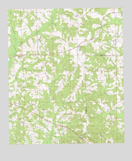
Texasville, AL USGS Topographic Map
Click on map above to begin viewing in our Map Viewer.

This topographic map contains these locations and features:
Feature Name Type Latitude Longitude GNIS ID View Map
Adams Chapel CemeteryCemeteryN31.7202°W85.3838°1729929View Map
Adams Chapel United Methodist ChurchChurchN31.7193°W85.3838°155847View Map
Anderson Baptist ChurchChurchN31.6774°W85.4841°155848View Map
Anderson CemeteryCemeteryN31.6771°W85.4849°1729894View Map
Anderson School (historical)SchoolN31.6766°W85.4830°134750View Map
Andrews Store (historical)LocaleN31.7316°W85.4777°134751View Map
Bethel ChurchChurchN31.6452°W85.4841°114042View Map
Black BranchStreamN31.7374°W85.4533°114399View Map
Black Gum Corners (historical)Populated PlaceN31.6824°W85.4166°134760View Map
Blue Springs High SchoolSchoolN31.6621°W85.4886°165360View Map
Boyds Store (historical)LocaleN31.7460°W85.4130°134761View Map
Browns Mill (historical)LocaleN31.7135°W85.3872°134763View Map
Clopton ChurchChurchN31.6404°W85.4377°164041View Map
Corinth Baptist ChurchChurchN31.7077°W85.4699°155860View Map
Corinth School (historical)SchoolN31.7068°W85.4674°155953View Map
Deer BranchStreamN31.6621°W85.4397°117195View Map
Double BranchStreamN31.7385°W85.3858°117403View Map
Duncan PondReservoirN31.6268°W85.4717°117665View Map
EdwinPopulated PlaceN31.6654°W85.3752°117883View Map
Edwin CemeteryCemeteryN31.6663°W85.3758°142968View Map
Fuqua Gin (historical)LocaleN31.6877°W85.4577°134787View Map
Grice Store (historical)LocaleN31.6996°W85.4922°134790View Map
Helms CemeteryCemeteryN31.6893°W85.4949°119938View Map
Joe HillSummitN31.6813°W85.4694°120901View Map
Jordan DitchCanalN31.6393°W85.3760°121049View Map
Lindsey CreekStreamN31.7179°W85.4908°155133View Map
Lingo PondReservoirN31.6565°W85.3817°121675View Map
Magnolia Memorial CemeteryCemeteryN31.6277°W85.4899°163352View Map
Magnolia United Methodist ChurchChurchN31.6279°W85.4899°155882View Map
Medley HillSummitN31.6457°W85.4791°122626View Map
Mount Enon ChurchChurchN31.6660°W85.3758°154638View Map
New Bethel Church (historical)ChurchN31.6543°W85.4710°1805342View Map
New Prospect Freewill Baptist ChurchChurchN31.6741°W85.4110°123882View Map
Prospect CemeteryCemeteryN31.6743°W85.4105°142967View Map
Saint Michaels ChurchChurchN31.6513°W85.3905°155230View Map
Saint Peters ChurchChurchN31.7429°W85.4255°126198View Map
Salem Church (historical)ChurchN31.7077°W85.4247°134820View Map
Shipes HillSummitN31.6566°W85.4638°126771View Map
Skippers BranchStreamN31.6974°W85.4980°1805351View Map
Spencers PondReservoirN31.7115°W85.4228°127187View Map
Spio (historical)Populated PlaceN31.6960°W85.4249°134826View Map
Spivey PondReservoirN31.6627°W85.4754°127191View Map
Springhill Baptist ChurchChurchN31.6668°W85.4519°127250View Map
Springhill CemeteryCemeteryN31.6671°W85.4519°1805474View Map
TewPopulated PlaceN31.6410°W85.4419°1805357View Map
Tew BranchStreamN31.6454°W85.4516°127777View Map
Tew CemeteryCemeteryN31.6482°W85.4399°127778View Map
TexasvillePopulated PlaceN31.7152°W85.4244°127783View Map
Texasville CemeteryCemeteryN31.7154°W85.4227°1805547View Map
Texasville United Methodist ChurchChurchN31.7154°W85.4235°155845View Map
Texasville Volunteer Fire DepartmentBuildingN31.7146°W85.4240°2691188View Map
Triumph ChurchChurchN31.7318°W85.4238°128081View Map
Turkey BranchStreamN31.6352°W85.4533°128132View Map
Walker HillSummitN31.6482°W85.4852°128522View Map
Wallace CreekStreamN31.6510°W85.4513°128539View Map
WGIQ-TV (Louisville)TowerN31.7182°W85.4341°161244View Map
Wilkinson BranchStreamN31.6329°W85.4538°153989View Map
Wilkinson PondLakeN31.6330°W85.4603°128987View Map
Wilson Gin (historical)LocaleN31.6527°W85.4372°1805360View Map

Note: Coordinates in the location and feature list above are referenced to NAD83 datum.


Copyright (C) 2008-2025 Ryan Niemi / Sunset Dynamics ... All Rights Reserved