TopoQuest Logo
Do you find TopoQuest useful?
Help keep TopoQuest running and adding new maps/features by donating!
Bitcoin:  19c7KJd3qBynnjoSw5npx9KScwjBe4ifkT
Litecoin:  LXs6TkuXGGXo1vDsWCkWVdjQX94eUKd6ui
Home View Maps Find Maps Find Places Resources & Links


Clayton South, Alabama Topographic Map

USGS Map Title: Clayton South, AL
USGS Map MRC: 31085G4
DRG (GeoTIFF) Download: o31085g4.tif


Neighboring USGS Topographic Map Quads:


  Mount Andrew, AL  
31085H5
 

  Clayton North, AL  
31085H4
 

  White Oak, AL  
31085H3
 

  Louisville, AL  
31085G5
 

  Clayton South, AL  
31085G4
 

  Baker Hill, AL  
31085G3
 

  Clio, AL  
31085F5
 

  Texasville, AL  
31085F4
 

  Lawrenceville, AL  
31085F3


Map MRC Location:

N32°
W86°
N32°
W85°
H8 H7 H6 H5 H4 H3 H2 H1
G8 G7 G6 G5 G4 G3 G2 G1
F8 F7 F6 F5 F4 F3 F2 F1
E8 E7 E6 E5 E4 E3 E2 E1
D8 D7 D6 D5 D4 D3 D2 D1
C8 C7 C6 C5 C4 C3 C2 C1
B8 B7 B6 B5 B4 B3 B2 B1
A8 A7 A6 A5 A4 A3 A2 A1
N31°
W86°
N31°
W85°

Clayton South, AL USGS 1:24K Topographic Map Preview:
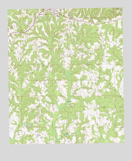
Clayton South, AL USGS Topographic Map
Click on map above to begin viewing in our Map Viewer.

This topographic map contains these locations and features:
Feature Name Type Latitude Longitude GNIS ID View Map
Adams Mill Pond DamDamN31.7568°W85.4399°129953View Map
Adams MillpondReservoirN31.7582°W85.4373°112929View Map
Antioch ChurchChurchN31.7835°W85.4316°113131View Map
Barbour CountyCivilN31.8696°W85.3932°161528View Map
Cox Mill (historical)LocaleN31.7610°W85.4397°134773View Map
Floyds Mill (historical)LocaleN31.8310°W85.4661°134785View Map
Floyds School (historical)SchoolN31.8168°W85.4483°134786View Map
Henry De Lamar Clayton HouseBuildingN31.8656°W85.4522°2491837View Map
Horn School (historical)SchoolN31.7749°W85.4105°134792View Map
Huttos Store (historical)LocaleN31.7854°W85.4035°134794View Map
Jackson CreekStreamN31.7538°W85.4963°120771View Map
Lime SinkPopulated PlaceN31.7829°W85.3980°156612View Map
LindseyPopulated PlaceN31.7582°W85.4694°121661View Map
Lords ChurchChurchN31.8624°W85.3874°163351View Map
Louisville Club PondLakeN31.7674°W85.4806°122052View Map
Louisville Club Pond DamDamN31.7668°W85.4833°129958View Map
Mercers Store (historical)LocaleN31.7813°W85.4141°134804View Map
Mill BranchStreamN31.7527°W85.4488°152322View Map
Millers FordCrossingN31.7891°W85.4369°156713View Map
Mount Mariah ChurchChurchN31.8110°W85.4010°123240View Map
Mount Scilla ChurchChurchN31.8549°W85.4019°152506View Map
Mount Zion ChurchChurchN31.8227°W85.4613°123453View Map
Norton School (historical)SchoolN31.8524°W85.4374°134810View Map
Pauls CreekStreamN31.7541°W85.4963°124505View Map
Pleasant Plains ChurchChurchN31.8321°W85.4402°125025View Map
Pleasant View CemeteryCemeteryN31.8063°W85.4049°1729930View Map
Pleasant View Presbyterian ChurchChurchN31.8057°W85.4052°155908View Map
Prospect Baptist ChurchChurchN31.7624°W85.4705°155912View Map
Richards Mill (historical)LocaleN31.8021°W85.3802°1805349View Map
Saint Marks ChurchChurchN31.7643°W85.3760°126158View Map
Saint Peters ChurchChurchN31.8546°W85.4847°126199View Map
Smith BranchStreamN31.7968°W85.3808°126990View Map
Spring Hill ChurchChurchN31.7760°W85.4688°164127View Map
Tabernacle CemeteryCemeteryN31.8160°W85.4755°127620View Map
Union Baptist ChurchChurchN31.8396°W85.3994°155926View Map
Walker Temple ChurchChurchN31.8624°W85.3852°134834View Map
Wallace High SchoolSchoolN31.8685°W85.4477°155291View Map
Warren CemeteryCemeteryN31.8713°W85.4830°128583View Map
Wesleyan Methodist Protestant ChurchChurchN31.8743°W85.4499°134835View Map

Note: Coordinates in the location and feature list above are referenced to NAD83 datum.


Copyright (C) 2008-2024 Ryan Niemi / Sunset Dynamics ... All Rights Reserved