TopoQuest Logo
Do you find TopoQuest useful?
Help keep TopoQuest running and adding new maps/features by donating!
Bitcoin:  19c7KJd3qBynnjoSw5npx9KScwjBe4ifkT
Litecoin:  LXs6TkuXGGXo1vDsWCkWVdjQX94eUKd6ui
Home View Maps Find Maps Find Places Resources & Links


Banks, Arkansas Topographic Map

USGS Map Title: Banks, AR
USGS Map MRC: 33092E3
DRG (GeoTIFF) Download: o33092e3.tif


Neighboring USGS Topographic Map Quads:


  Chambersville, AR  
33092F4
 

  Tinsman, AR  
33092F3
 

  McKinney, AR  
33092F2
 

  Hampton, AR  
33092E4
 

  Banks, AR  
33092E3
 

  Farmville, AR  
33092E2
 

  Artesian, AR  
33092D4
 

  Jersey, AR  
33092D3
 

  Hermitage, AR  
33092D2


Map MRC Location:

N34°
W93°
N34°
W92°
H8 H7 H6 H5 H4 H3 H2 H1
G8 G7 G6 G5 G4 G3 G2 G1
F8 F7 F6 F5 F4 F3 F2 F1
E8 E7 E6 E5 E4 E3 E2 E1
D8 D7 D6 D5 D4 D3 D2 D1
C8 C7 C6 C5 C4 C3 C2 C1
B8 B7 B6 B5 B4 B3 B2 B1
A8 A7 A6 A5 A4 A3 A2 A1
N33°
W93°
N33°
W92°

Banks, AR USGS 1:24K Topographic Map Preview:
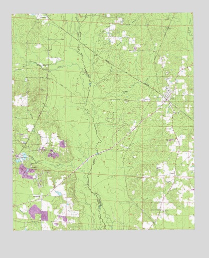
Banks, AR USGS Topographic Map
Click on map above to begin viewing in our Map Viewer.

This topographic map contains these locations and features:
Feature Name Type Latitude Longitude GNIS ID View Map
Alta JunctionLocaleN33.6015°W92.2751°60511View Map
BanksPopulated PlaceN33.5748°W92.2690°46076View Map
Banks Volunteer Fire DepartmentBuildingN33.5773°W92.2702°2116108View Map
Cagle SpringSpringN33.5813°W92.3556°47272View Map
Caney CreekStreamN33.5593°W92.3185°47402View Map
Center Ridge School (historical)SchoolN33.6043°W92.2940°60510View Map
Childs CemeteryCemeteryN33.5112°W92.2718°47740View Map
Church of God in ChristChurchN33.5112°W92.2735°47777View Map
Dickinson ChurchChurchN33.5373°W92.3621°48508View Map
Emerson BranchStreamN33.5973°W92.3632°48888View Map
Glynn (historical)Populated PlaceN33.6209°W92.2649°60512View Map
Harrell LakeReservoirN33.5214°W92.3433°81197View Map
Harrell Lake DamDamN33.5201°W92.3418°81196View Map
Hurricane BranchStreamN33.5879°W92.3218°50429View Map
Hurricane CreekStreamN33.5893°W92.3232°50444View Map
Jacks CreekStreamN33.5276°W92.3235°50549View Map
LanarkPopulated PlaceN33.5312°W92.2646°57085View Map
Lanark School (historical)SchoolN33.5040°W92.2685°60509View Map
Marlow BranchStreamN33.5412°W92.3610°51680View Map
McFarland CemeteryCemeteryN33.5870°W92.2696°51833View Map
McLeod CemeteryCemeteryN33.5745°W92.2979°51867View Map
Moro Farm (historical)LocaleN33.5651°W92.3732°69993View Map
Pleasant Grove ChurchChurchN33.5379°W92.3629°53536View Map
Smith CemeteryCemeteryN33.5518°W92.2676°54932View Map
SummervillePopulated PlaceN33.5204°W92.3557°58712View Map
Town of BanksCivilN33.5759°W92.2671°2405207View Map
Township of ClayCivilN33.5451°W92.2666°63687View Map
Township of Dallas (historical)CivilN33.5834°W92.3746°63699View Map
Watson CreekStreamN33.6134°W92.3296°56112View Map
Wheeler BranchStreamN33.5848°W92.3163°56223View Map

Note: Coordinates in the location and feature list above are referenced to NAD83 datum.


Copyright (C) 2008-2025 Ryan Niemi / Sunset Dynamics ... All Rights Reserved