TopoQuest Logo
Do you find TopoQuest useful?
Help keep TopoQuest running and adding new maps/features by donating!
Bitcoin:  19c7KJd3qBynnjoSw5npx9KScwjBe4ifkT
Litecoin:  LXs6TkuXGGXo1vDsWCkWVdjQX94eUKd6ui
Home View Maps Find Maps Find Places Resources & Links


Jersey, Arkansas Topographic Map

USGS Map Title: Jersey, AR
USGS Map MRC: 33092D3
DRG (GeoTIFF) Download: o33092d3.tif


Neighboring USGS Topographic Map Quads:


  Hampton, AR  
33092E4
 

  Banks, AR  
33092E3
 

  Farmville, AR  
33092E2
 

  Artesian, AR  
33092D4
 

  Jersey, AR  
33092D3
 

  Hermitage, AR  
33092D2
 

  Harrell Brake, AR  
33092C4
 

  Moro Bay, AR  
33092C3
 

  Marsden, AR  
33092C2


Map MRC Location:

N34°
W93°
N34°
W92°
H8 H7 H6 H5 H4 H3 H2 H1
G8 G7 G6 G5 G4 G3 G2 G1
F8 F7 F6 F5 F4 F3 F2 F1
E8 E7 E6 E5 E4 E3 E2 E1
D8 D7 D6 D5 D4 D3 D2 D1
C8 C7 C6 C5 C4 C3 C2 C1
B8 B7 B6 B5 B4 B3 B2 B1
A8 A7 A6 A5 A4 A3 A2 A1
N33°
W93°
N33°
W92°

Jersey, AR USGS 1:24K Topographic Map Preview:
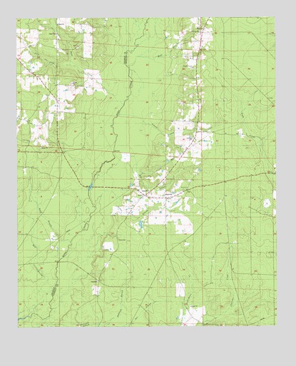
Jersey, AR USGS Topographic Map
Click on map above to begin viewing in our Map Viewer.

This topographic map contains these locations and features:
Feature Name Type Latitude Longitude GNIS ID View Map
At ChurchChurchN33.3882°W92.3371°60549View Map
Bailey FordCrossingN33.4071°W92.3504°60547View Map
Beech BranchStreamN33.4073°W92.3507°46310View Map
Belin CemeteryCemeteryN33.4868°W92.2868°60557View Map
Child SchoolSchoolN33.4787°W92.2918°47737View Map
Dunn CreekStreamN33.4626°W92.3265°48715View Map
Hines CemeteryCemeteryN33.4073°W92.3268°60548View Map
JerseyPopulated PlaceN33.4284°W92.3143°57991View Map
Jersey Methodist ChurchChurchN33.4271°W92.3118°61684View Map
Jersey Rural Fire DepartmentBuildingN33.4269°W92.3055°2116632View Map
Jersey SchoolSchoolN33.4348°W92.3040°50629View Map
Jolly CreekStreamN33.4821°W92.3496°50710View Map
Jordan BranchStreamN33.4235°W92.3374°50741View Map
Lavilliam CemeteryCemeteryN33.4509°W92.2904°60555View Map
Lee BranchStreamN33.3754°W92.3346°51039View Map
Mill BranchStreamN33.4426°W92.3299°51977View Map
Mill FordCrossingN33.4451°W92.3296°58181View Map
Mount Zion Baptist ChurchChurchN33.4312°W92.2929°60550View Map
Mount Zion CemeteryCemeteryN33.4301°W92.2926°60551View Map
Mud SpringsSpringN33.4448°W92.3118°60554View Map
Pin Oak FlatFlatN33.3790°W92.3357°60546View Map
Pin Oak FlatFlatN33.4876°W92.2657°60559View Map
Primitive Baptist ChurchChurchN33.4798°W92.2901°60556View Map
Primitive Baptist ChurchChurchN33.4940°W92.2857°60558View Map
Ricks CemeteryCemeteryN33.4882°W92.3465°54030View Map
Ricks ChurchChurchN33.4887°W92.3451°61613View Map
Robinson BranchStreamN33.3751°W92.3343°54074View Map
Saint Lena SchoolSchoolN33.4984°W92.3563°54378View Map
Shady Grove CemeteryCemeteryN33.4334°W92.3037°60553View Map
Shady Grove Missionary Baptist ChurchChurchN33.4343°W92.3038°60552View Map
Township of Jackson (historical)CivilN33.4335°W92.3724°63703View Map
Township of SumpterCivilN33.4112°W92.3006°63695View Map
Union Grove ChurchChurchN33.4504°W92.3710°55818View Map
Villum BranchStreamN33.4532°W92.3282°55917View Map
Wahl BranchStreamN33.4601°W92.3238°55943View Map

Note: Coordinates in the location and feature list above are referenced to NAD83 datum.


Copyright (C) 2008-2025 Ryan Niemi / Sunset Dynamics ... All Rights Reserved