TopoQuest Logo
Do you find TopoQuest useful?
Help keep TopoQuest running and adding new maps/features by donating!
Bitcoin:  19c7KJd3qBynnjoSw5npx9KScwjBe4ifkT
Litecoin:  LXs6TkuXGGXo1vDsWCkWVdjQX94eUKd6ui
Home View Maps Find Maps Find Places Resources & Links


Jeffersonville, Ohio Topographic Map

USGS Map Title: Jeffersonville, OH
USGS Map MRC: 39083F5
DRG (GeoTIFF) Download: o39083f5.tif


Neighboring USGS Topographic Map Quads:


  South Charleston, OH  
39083G6
 

  Florence, OH  
39083G5
 

  Walnut Run, OH  
39083G4
 

  Jamestown, OH  
39083F6
 

  Jeffersonville, OH  
39083F5
 

  Midway, OH  
39083F4
 

  Bowersville, OH  
39083E6
 

  Milledgeville, OH  
39083E5
 

  Washington Court House, OH  
39083E4


Map MRC Location:

N40°
W84°
N40°
W83°
H8 H7 H6 H5 H4 H3 H2 H1
G8 G7 G6 G5 G4 G3 G2 G1
F8 F7 F6 F5 F4 F3 F2 F1
E8 E7 E6 E5 E4 E3 E2 E1
D8 D7 D6 D5 D4 D3 D2 D1
C8 C7 C6 C5 C4 C3 C2 C1
B8 B7 B6 B5 B4 B3 B2 B1
A8 A7 A6 A5 A4 A3 A2 A1
N39°
W84°
N39°
W83°

Jeffersonville, OH USGS 1:24K Topographic Map Preview:
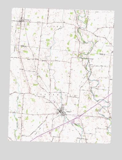
Jeffersonville, OH USGS Topographic Map
Click on map above to begin viewing in our Map Viewer.

This topographic map contains these locations and features:
Feature Name Type Latitude Longitude GNIS ID View Map
BlessingPopulated PlaceN39.7026°W83.6035°1064448View Map
Blessings School (historical)SchoolN39.6923°W83.5802°1080803View Map
Booco - Ryan CemeteryCemeteryN39.6303°W83.6078°1070686View Map
BookwalterPopulated PlaceN39.7045°W83.5302°1070687View Map
Bookwalter Church of Christ in Christian UnionChurchN39.7028°W83.5296°1071562View Map
Bookwalter Post Office (historical)Post OfficeN39.7042°W83.5305°1985344View Map
Bookwalter SchoolSchoolN39.6984°W83.5294°1038197View Map
Cozy CornersLocaleN39.6492°W83.5002°1039429View Map
Dumpling HillSummitN39.6926°W83.6088°1048669View Map
Fairview CemeteryCemeteryN39.6667°W83.5827°1040326View Map
Grassy Plain School (historical)SchoolN39.7262°W83.5227°1054043View Map
Harold School (historical)SchoolN39.6895°W83.5519°1080804View Map
Hidy CemeteryCemeteryN39.6698°W83.5216°1041538View Map
Hidy School (historical)SchoolN39.6673°W83.5046°1080806View Map
Highbee CemeteryCemeteryN39.6284°W83.5307°1070776View Map
Hillside School (historical)SchoolN39.6826°W83.6038°1080802View Map
Hogue - Allen CemeteryCemeteryN39.6472°W83.6096°1041658View Map
Interchange 69CrossingN39.6489°W83.5402°1080276View Map
Jefferson Township Fire Department Station 500BuildingN39.6533°W83.5619°2549411View Map
JeffersonvillePopulated PlaceN39.6537°W83.5638°1042071View Map
Jeffersonville ChurchChurchN39.6620°W83.5749°1066772View Map
Jeffersonville Elementary SchoolSchoolN39.6520°W83.5649°1055151View Map
Jeffersonville Post OfficePost OfficeN39.6542°W83.5638°1985478View Map
Jeffersonville United Methodist ChurchChurchN39.6542°W83.5624°1063487View Map
Kirk CemeteryCemeteryN39.6412°W83.5041°1071574View Map
Maple Grove School (historical)SchoolN39.6967°W83.5046°1080808View Map
McKillip - Kirk CemeteryCemeteryN39.6687°W83.5460°1043122View Map
Old Jeffersonville CemeteryCemeteryN39.6559°W83.5641°1055154View Map
Slaughter School (historical)SchoolN39.7309°W83.5474°1054045View Map
South SolonPopulated PlaceN39.7378°W83.6133°1065356View Map
South Solon CemeteryCemeteryN39.7353°W83.6166°1068835View Map
South Solon Post OfficePost OfficeN39.7376°W83.6138°2030272View Map
South Solon SchoolSchoolN39.7403°W83.6127°1068836View Map
Stokes Township Fire DepartmentBuildingN39.7371°W83.6102°2550277View Map
Sunnyside School (historical)SchoolN39.6506°W83.6085°1080801View Map
Thomas CemeteryCemeteryN39.7378°W83.5899°1047022View Map
Thomas School (historical)SchoolN39.7364°W83.5869°1054046View Map
Township of JeffersonCivilN39.6520°W83.5782°1086089View Map
Township of StokesCivilN39.7447°W83.5716°1086553View Map
Twin Oak DairyLocaleN39.7194°W83.5119°2703620View Map
Village of JeffersonvilleCivilN39.6522°W83.5564°2398293View Map
Village of South SolonCivilN39.7374°W83.6127°2399859View Map
Walnut Hill School (historical)SchoolN39.6842°W83.5302°1080807View Map
Walnut Ridge School (historical)SchoolN39.6267°W83.5302°1080805View Map
Wesley Chapel Church (historical)ChurchN39.6970°W83.5038°1071588View Map
Whiteman CemeteryCemeteryN39.7189°W83.5360°1070993View Map

Note: Coordinates in the location and feature list above are referenced to NAD83 datum.


Copyright (C) 2008-2025 Ryan Niemi / Sunset Dynamics ... All Rights Reserved