TopoQuest Logo
Do you find TopoQuest useful?
Help keep TopoQuest running and adding new maps/features by donating!
Bitcoin:  19c7KJd3qBynnjoSw5npx9KScwjBe4ifkT
Litecoin:  LXs6TkuXGGXo1vDsWCkWVdjQX94eUKd6ui
Home View Maps Find Maps Find Places Resources & Links


Rayville, Missouri Topographic Map

USGS Map Title: Rayville, MO
USGS Map MRC: 39094C1
DRG (GeoTIFF) Download: o39094c1.tif


Neighboring USGS Topographic Map Quads:


  Lawson, MO  
39094D2
 

  Knoxville, MO  
39094D1
 

  Millville, MO  
39093D8
 

  Excelsior Springs, MO  
39094C2
 

  Rayville, MO  
39094C1
 

  Richmond, MO  
39093C8
 

  Buckner, MO  
39094B2
 

  Camden, MO  
39094B1
 

  Lexington West, MO  
39093B8


Map MRC Location:

N40°
W95°
N40°
W94°
H8 H7 H6 H5 H4 H3 H2 H1
G8 G7 G6 G5 G4 G3 G2 G1
F8 F7 F6 F5 F4 F3 F2 F1
E8 E7 E6 E5 E4 E3 E2 E1
D8 D7 D6 D5 D4 D3 D2 D1
C8 C7 C6 C5 C4 C3 C2 C1
B8 B7 B6 B5 B4 B3 B2 B1
A8 A7 A6 A5 A4 A3 A2 A1
N39°
W95°
N39°
W94°

Rayville, MO USGS 1:24K Topographic Map Preview:
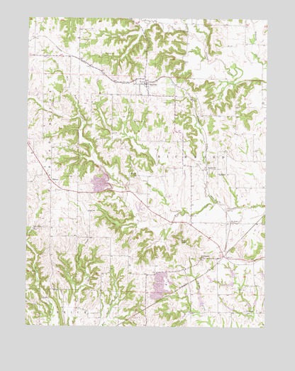
Rayville, MO USGS Topographic Map
Click on map above to begin viewing in our Map Viewer.

This topographic map contains these locations and features:
Feature Name Type Latitude Longitude GNIS ID View Map
Crowley CemeteryCemeteryN39.3411°W94.0494°716551View Map
Dale SchoolSchoolN39.3122°W94.0252°716645View Map
ElkhornPopulated PlaceN39.3092°W94.1127°730093View Map
Elkhorn Elementary SchoolSchoolN39.3236°W94.1240°2545432View Map
Fitch SchoolSchoolN39.2567°W94.0099°717964View Map
Gordan CemeteryCemeteryN39.2553°W94.0874°718609View Map
Hamilton CemeteryCemeteryN39.3108°W94.1010°719033View Map
Jacobs CemeteryCemeteryN39.3217°W94.0066°720226View Map
McGaugh CemeteryCemeteryN39.3608°W94.0852°722104View Map
McGill SchoolSchoolN39.3114°W94.0680°722113View Map
Ogg SchoolSchoolN39.2970°W94.0933°723704View Map
Oggs MillLocaleN39.2972°W94.0861°747107View Map
Pettus CemeteryCemeteryN39.2936°W94.0991°724270View Map
Ray A-246 LakeReservoirN39.2602°W94.0050°760567View Map
Ray County Number A-24b LakeReservoirN39.2718°W94.0171°760580View Map
RayvillePopulated PlaceN39.3483°W94.0630°730188View Map
Rayville Census Designated PlaceCensusN39.3463°W94.0649°2761657View Map
Rayville Post OfficePost OfficeN39.3489°W94.0631°2783042View Map
Rock Falls ChurchChurchN39.2895°W94.1222°725455View Map
Rocky ForkStreamN39.3722°W94.0427°730198View Map
Saint CloudPopulated PlaceN39.2928°W94.0183°741228View Map
Sanderson CemeteryCemeteryN39.3333°W94.0702°726031View Map
Sanderson School (historical)SchoolN39.2789°W94.0722°747106View Map
SwanwickPopulated PlaceN39.3142°W94.0311°741305View Map
Swofford LakeReservoirN39.2596°W94.0332°760578View Map
Todds ChapelChurchN39.2853°W94.0447°727695View Map
Turnage School (historical)SchoolN39.3361°W94.0316°747105View Map
Vanderpool SchoolSchoolN39.2778°W94.0336°728140View Map
Vandiver and Barchers Number A-2 ReservoirReservoirN39.2580°W94.0185°760582View Map
Village of Rayville (historical)CivilN39.3478°W94.0647°2399051View Map
Williams CemeteryCemeteryN39.3153°W94.0366°728889View Map
Willow Creek Watershed Dam A-22DamN39.2583°W94.0336°760577View Map
Willow Creek Watershed Dam A-23DamN39.2567°W94.0152°760581View Map
Willow Creek Watershed Dam A-24aDamN39.2683°W94.0152°761894View Map
Willow Creek Watershed Dam A-24bDamN39.2700°W94.0152°760579View Map
Willow Creek Watershed Dam A-26DamN39.2583°W94.0086°761895View Map
Willow Creek Watershed Dam A-28DamN39.2683°W94.0269°761893View Map
Willow Creek Watershed Dam A-30DamN39.2583°W94.0052°760566View Map
Willow Creek Watershed Dam B-22DamN39.2717°W94.0002°762651View Map

Note: Coordinates in the location and feature list above are referenced to NAD83 datum.


Copyright (C) 2008-2025 Ryan Niemi / Sunset Dynamics ... All Rights Reserved