TopoQuest Logo
Do you find TopoQuest useful?
Help keep TopoQuest running and adding new maps/features by donating!
Bitcoin:  19c7KJd3qBynnjoSw5npx9KScwjBe4ifkT
Litecoin:  LXs6TkuXGGXo1vDsWCkWVdjQX94eUKd6ui
Home View Maps Find Maps Find Places Resources & Links


Center Ridge, Mississippi Topographic Map

USGS Map Title: Center Ridge, MS
USGS Map MRC: 31089H4
DRG (GeoTIFF) Download: o31089h4.tif


Neighboring USGS Topographic Map Quads:


  Raleigh, MS  
32089A5
 

  Louin SW, MS  
32089A4
 

  Louin, MS  
32089A3
 

  Cohay, MS  
31089H5
 

  Center Ridge, MS  
31089H4
 

  Bay Springs, MS  
31089H3
 

  Mize, MS  
31089G5
 

  Taylorsville, MS  
31089G4
 

  Soso, MS  
31089G3


Map MRC Location:

N32°
W90°
N32°
W89°
H8 H7 H6 H5 H4 H3 H2 H1
G8 G7 G6 G5 G4 G3 G2 G1
F8 F7 F6 F5 F4 F3 F2 F1
E8 E7 E6 E5 E4 E3 E2 E1
D8 D7 D6 D5 D4 D3 D2 D1
C8 C7 C6 C5 C4 C3 C2 C1
B8 B7 B6 B5 B4 B3 B2 B1
A8 A7 A6 A5 A4 A3 A2 A1
N31°
W90°
N31°
W89°

Center Ridge, MS USGS 1:24K Topographic Map Preview:
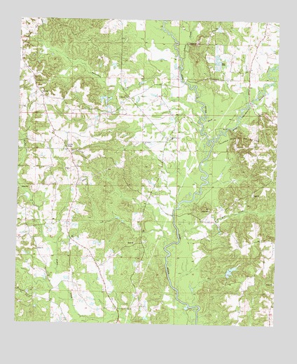
Center Ridge, MS USGS Topographic Map
Click on map above to begin viewing in our Map Viewer.

This topographic map contains these locations and features:
Feature Name Type Latitude Longitude GNIS ID View Map
Beaverdam Baptist Church CemeteryCemeteryN31.9678°W89.4485°2766913View Map
Beaverdam ChurchChurchN31.9679°W89.4490°666726View Map
Beaverdam CreekStreamN31.9765°W89.4237°666728View Map
BezerPopulated PlaceN31.9710°W89.4903°707236View Map
Blackwell Lake DamDamN31.9668°W89.4534°680965View Map
Blackwell Lake DamDamN31.9835°W89.4201°680972View Map
Blakeney (historical)LocaleN31.9682°W89.4465°707238View Map
Burnett CemeteryCemeteryN31.9457°W89.4706°707244View Map
Center RidgePopulated PlaceN31.9471°W89.4770°691760View Map
Center Ridge ChurchChurchN31.9452°W89.4740°685069View Map
Center Ridge School (historical)SchoolN31.9452°W89.4737°707245View Map
Clarke Lake DamDamN31.8952°W89.3984°680934View Map
Ditch CemeteryCemeteryN31.9702°W89.4892°669275View Map
East Tallahalla Creek Oil FieldOilfieldN31.9613°W89.3959°707248View Map
Hissop (historical)LocaleN31.8815°W89.4512°707250View Map
Ichusa CreekStreamN31.9846°W89.4231°693576View Map
Johnson School (historical)SchoolN31.9765°W89.4076°685079View Map
Keys Mill CreekStreamN31.9107°W89.4217°672117View Map
Liberty ChurchChurchN31.9743°W89.4923°672447View Map
Mill CreekStreamN31.9990°W89.4334°693997View Map
Mineral SpringsPopulated PlaceN31.9510°W89.4284°685081View Map
Mineral Springs ChurchChurchN31.9521°W89.4281°673671View Map
Mineral Springs School (historical)SchoolN31.9418°W89.4301°685082View Map
New Bethel ChurchChurchN31.9502°W89.4412°674575View Map
Prairie CreekStreamN31.9663°W89.3903°694469View Map
Saint John ChurchChurchN31.9765°W89.4078°677054View Map
Supervisor District 1CivilN31.9481°W89.4823°712070View Map
Tallahala Creek Oil and Gas FieldOilfieldN31.9521°W89.3923°678544View Map
Thompson Mill CreekStreamN31.9746°W89.3778°678715View Map
West Tallahala CreekStreamN31.9510°W89.4070°695137View Map
Zion ChurchChurchN31.8818°W89.4459°679994View Map

Note: Coordinates in the location and feature list above are referenced to NAD83 datum.


Copyright (C) 2008-2025 Ryan Niemi / Sunset Dynamics ... All Rights Reserved