TopoQuest Logo
Do you find TopoQuest useful?
Help keep TopoQuest running and adding new maps/features by donating!
Bitcoin:  19c7KJd3qBynnjoSw5npx9KScwjBe4ifkT
Litecoin:  LXs6TkuXGGXo1vDsWCkWVdjQX94eUKd6ui
Home View Maps Find Maps Find Places Resources & Links


Louin SW, Mississippi Topographic Map

USGS Map Title: Louin SW, MS
USGS Map MRC: 32089A4
DRG (GeoTIFF) Download: o32089a4.tif


Neighboring USGS Topographic Map Quads:


  Homewood, MS  
32089B5
 

  Pineville, MS  
32089B4
 

  Clear Springs, MS  
32089B3
 

  Raleigh, MS  
32089A5
 

  Louin SW, MS  
32089A4
 

  Louin, MS  
32089A3
 

  Cohay, MS  
31089H5
 

  Center Ridge, MS  
31089H4
 

  Bay Springs, MS  
31089H3


Map MRC Location:

N33°
W90°
N33°
W89°
H8 H7 H6 H5 H4 H3 H2 H1
G8 G7 G6 G5 G4 G3 G2 G1
F8 F7 F6 F5 F4 F3 F2 F1
E8 E7 E6 E5 E4 E3 E2 E1
D8 D7 D6 D5 D4 D3 D2 D1
C8 C7 C6 C5 C4 C3 C2 C1
B8 B7 B6 B5 B4 B3 B2 B1
A8 A7 A6 A5 A4 A3 A2 A1
N32°
W90°
N32°
W89°

Louin SW, MS USGS 1:24K Topographic Map Preview:
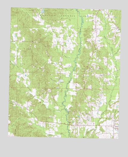
Louin SW, MS USGS Topographic Map
Click on map above to begin viewing in our Map Viewer.

This topographic map contains these locations and features:
Feature Name Type Latitude Longitude GNIS ID View Map
Bailey Lake DamDamN32.1235°W89.4651°695421View Map
Bethel Church (historical)ChurchN32.0549°W89.4142°704919View Map
Bowling CreekStreamN32.0740°W89.4273°692679View Map
Cedar Grove ChurchChurchN32.0665°W89.4140°692865View Map
Chisholm BranchStreamN32.0529°W89.4342°692895View Map
Christian ChapelChurchN32.1227°W89.4748°692901View Map
Craft School (historical)SchoolN32.0563°W89.4603°704922View Map
Double ChurchChurchN32.0460°W89.4576°693105View Map
Flat Rock HillRidgeN32.0043°W89.4906°693228View Map
High Hill Baptist Church CemeteryCemeteryN32.0858°W89.4781°2781341View Map
High Hill ChurchChurchN32.0852°W89.4776°693475View Map
Jesus Name ChurchChurchN32.0610°W89.3931°693616View Map
Johnson CemeteryCemeteryN32.0147°W89.4218°693625View Map
Lemon Christian CemeteryCemeteryN32.1225°W89.4747°2766925View Map
Little CreekStreamN32.0632°W89.4295°693756View Map
Little Ichusa CreekStreamN32.0813°W89.3831°693765View Map
Little Shongelo CreekStreamN32.0657°W89.4867°693781View Map
Moore CemeteryCemeteryN32.0132°W89.4658°2781339View Map
Morgan CreekStreamN32.0129°W89.4698°694034View Map
Mount Nebo Baptist Church CemeteryCemeteryN32.0980°W89.4317°2766914View Map
Mount Nebo CemeteryCemeteryN32.0952°W89.4678°694069View Map
Mount Nebo ChurchChurchN32.0985°W89.4317°694072View Map
Mount PleasantPopulated PlaceN32.0232°W89.4126°707254View Map
Mount Pleasant ChurchChurchN32.0229°W89.4120°694097View Map
Nelse BranchStreamN32.0129°W89.4701°694152View Map
Old Henderson CemeteryCemeteryN32.1200°W89.4919°2766933View Map
Pete BranchStreamN32.1110°W89.4637°694350View Map
Royal (historical)LocaleN32.0946°W89.4037°707264View Map
Royals and Webb CemeteryCemeteryN32.0935°W89.4100°694623View Map
Saint Johns Methodist ChurchChurchN32.0132°W89.3798°707265View Map
Sand PointPopulated PlaceN32.0882°W89.4606°707266View Map
Shongelo CreekStreamN32.0285°W89.4370°694777View Map
Shongelo Creek Oil FieldOilfieldN32.0627°W89.4626°707267View Map
Spring LakesReservoirN32.1214°W89.4643°694875View Map
Sylvan Grove CemeteryCemeteryN32.1138°W89.4532°694922View Map
SylvarenaPopulated PlaceN32.0110°W89.3806°694923View Map
Sylvarena Academy (historical)SchoolN32.0127°W89.3798°707274View Map
Sylvarena Attendance CenterSchoolN32.0146°W89.3798°707275View Map
Teock CreekStreamN32.1249°W89.4262°694956View Map
Thompson Lake DamDamN32.0968°W89.4951°695418View Map
Trade (historical)LocaleN32.0554°W89.4612°707278View Map
Trinity CemeteryCemeteryN32.0920°W89.4756°1805884View Map
Trinity Methodist ChurchChurchN32.0921°W89.4748°695005View Map
Village of SylvarenaCivilN32.0144°W89.3818°2407557View Map

Note: Coordinates in the location and feature list above are referenced to NAD83 datum.


Copyright (C) 2008-2024 Ryan Niemi / Sunset Dynamics ... All Rights Reserved