TopoQuest Logo
Do you find TopoQuest useful?
Help keep TopoQuest running and adding new maps/features by donating!
Bitcoin:  19c7KJd3qBynnjoSw5npx9KScwjBe4ifkT
Litecoin:  LXs6TkuXGGXo1vDsWCkWVdjQX94eUKd6ui
Home View Maps Find Maps Find Places Resources & Links


Colfax, Iowa Topographic Map

USGS Map Title: Colfax, IA
USGS Map MRC: 41093F2
DRG (GeoTIFF) Download: o41093f2.tif


Neighboring USGS Topographic Map Quads:


  Mingo, IA  
41093G3
 

  Baxter, IA  
41093G2
 

  Baxter SE, IA  
41093G1
 

  Mitchellville, IA  
41093F3
 

  Colfax, IA  
41093F2
 

  Newton, IA  
41093F1
 

  Runnells, IA  
41093E3
 

  Prairie City, IA  
41093E2
 

  Monroe, IA  
41093E1


Map MRC Location:

N42°
W94°
N42°
W93°
H8 H7 H6 H5 H4 H3 H2 H1
G8 G7 G6 G5 G4 G3 G2 G1
F8 F7 F6 F5 F4 F3 F2 F1
E8 E7 E6 E5 E4 E3 E2 E1
D8 D7 D6 D5 D4 D3 D2 D1
C8 C7 C6 C5 C4 C3 C2 C1
B8 B7 B6 B5 B4 B3 B2 B1
A8 A7 A6 A5 A4 A3 A2 A1
N41°
W94°
N41°
W93°

Colfax, IA USGS 1:24K Topographic Map Preview:
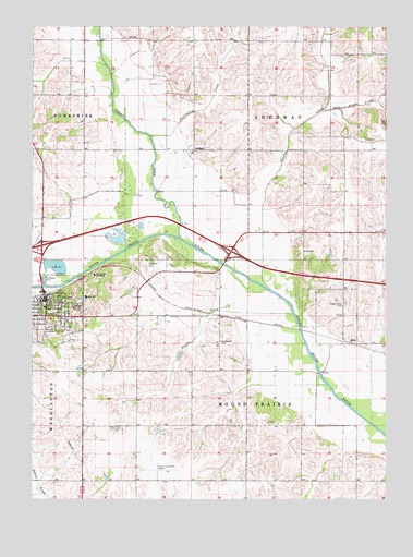
Colfax, IA USGS Topographic Map
Click on map above to begin viewing in our Map Viewer.

This topographic map contains these locations and features:
Feature Name Type Latitude Longitude GNIS ID View Map
Assembly of God ChurchChurchN41.6736°W93.2474°1999667View Map
Bush Post Office (historical)Post OfficeN41.6622°W93.1369°1999573View Map
Chalybeate Springs Post Office (historical)Post OfficeN41.6778°W93.2419°1999543View Map
City of ColfaxCivilN41.6801°W93.2386°2393595View Map
ColfaxLocaleN41.6783°W93.2471°1999665View Map
ColfaxPopulated PlaceN41.6778°W93.2452°455527View Map
Colfax - Mingo Elementary SchoolSchoolN41.6755°W93.2455°1999675View Map
Colfax - Mingo High SchoolSchoolN41.6784°W93.2312°1999674View Map
Colfax City HallBuildingN41.6775°W93.2455°1999661View Map
Colfax Family Care Associates CenterHospitalN41.6778°W93.2444°1999666View Map
Colfax Fire DepartmentBuildingN41.6732°W93.2472°2577366View Map
Colfax Post OfficePost OfficeN41.6786°W93.2430°1999663View Map
Colfax Presbyterian ChurchChurchN41.6775°W93.2446°1999668View Map
Colfax Public Hunting AreaAreaN41.6950°W93.2169°464373View Map
Colfax Public LibraryBuildingN41.6769°W93.2463°1999662View Map
Colfax United Methodist ChurchChurchN41.6767°W93.2471°1999670View Map
East Grand CreekStreamN41.7278°W93.1480°456156View Map
First Baptist ChurchChurchN41.6764°W93.2446°1999673View Map
Fullington CreekStreamN41.7208°W93.2085°456802View Map
GoddardPopulated PlaceN41.7175°W93.1930°464565View Map
Goddard Post Office (historical)Post OfficeN41.7175°W93.1930°1999576View Map
Highland CemeteryCemeteryN41.6708°W93.2436°457461View Map
Howard Street Christian ChurchChurchN41.6775°W93.2471°1999669View Map
Immaculate Conception Catholic ChurchChurchN41.6789°W93.2408°1999671View Map
Indian CreekStreamN41.6944°W93.1989°2559902View Map
Interchange 155CrossingN41.6917°W93.2469°1999589View Map
Interchange 159CrossingN41.6905°W93.1808°1999588View Map
Kelley Family Burial GroundCemeteryN41.6555°W93.1891°1999712View Map
MetzLocaleN41.6664°W93.1358°1999575View Map
MetzPopulated PlaceN41.6664°W93.1358°464654View Map
Metz Community ChurchChurchN41.6667°W93.1419°2000423View Map
Metz Post Office (historical)Post OfficeN41.6664°W93.1358°1999574View Map
New Life Baptist ChurchChurchN41.6783°W93.2435°1999672View Map
Parkersburgh Post Office (historical)Post OfficeN41.6847°W93.1835°1999572View Map
Prairie City-Krohn Airport (historical)AirportN41.6333°W93.2002°466921View Map
Prairie CreekStreamN41.6805°W93.1663°460398View Map
Rorabaugh CemeteryCemeteryN41.6666°W93.1837°460781View Map
Schlosser ParkParkN41.6839°W93.2463°461466View Map
Seevers (historical)LocaleN41.6517°W93.2133°1999577View Map
Seevers Post Office (historical)Post OfficeN41.6517°W93.2133°1999578View Map
SeversPopulated PlaceN41.6517°W93.2133°464216View Map
Severs CreekStreamN41.6742°W93.1580°461511View Map
Slaughter CemeteryCemeteryN41.6867°W93.2096°461670View Map
Sugar Grove CemeteryCemeteryN41.6768°W93.1406°462068View Map
Township of Mound PrairieCivilN41.6454°W93.1753°468414View Map
Township of ShermanCivilN41.7330°W93.1681°468698View Map
Trainland USABuildingN41.6805°W93.2460°1999664View Map
Watson Station Post Office (historical)Post OfficeN41.6744°W93.1871°466490View Map

Note: Coordinates in the location and feature list above are referenced to NAD83 datum.


Copyright (C) 2008-2025 Ryan Niemi / Sunset Dynamics ... All Rights Reserved