TopoQuest Logo
Do you find TopoQuest useful?
Help keep TopoQuest running and adding new maps/features by donating!
Bitcoin:  19c7KJd3qBynnjoSw5npx9KScwjBe4ifkT
Litecoin:  LXs6TkuXGGXo1vDsWCkWVdjQX94eUKd6ui
Home View Maps Find Maps Find Places Resources & Links


Conant Valley, Idaho Topographic Map

USGS Map Title: Conant Valley, ID
USGS Map MRC: 43111D4
DRG (GeoTIFF) Download: o43111d4.tif


Neighboring USGS Topographic Map Quads:


  Heise SE, ID  
43111E5
 

  Wheaton Mountain, ID  
43111E4
 

  Stouts Mountain, ID  
43111E3
 

  Point Lookout, ID  
43111D5
 

  Conant Valley, ID  
43111D4
 

  Swan Valley, ID  
43111D3
 

  Castle Rock, ID  
43111C5
 

  Commissary Ridge, ID  
43111C4
 

  Red Ridge, ID  
43111C3


Map MRC Location:

N44°
W112°
N44°
W111°
H8 H7 H6 H5 H4 H3 H2 H1
G8 G7 G6 G5 G4 G3 G2 G1
F8 F7 F6 F5 F4 F3 F2 F1
E8 E7 E6 E5 E4 E3 E2 E1
D8 D7 D6 D5 D4 D3 D2 D1
C8 C7 C6 C5 C4 C3 C2 C1
B8 B7 B6 B5 B4 B3 B2 B1
A8 A7 A6 A5 A4 A3 A2 A1
N43°
W112°
N43°
W111°

Conant Valley, ID USGS 1:24K Topographic Map Preview:
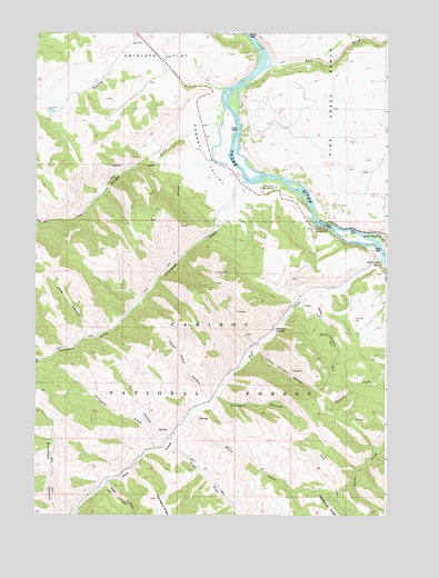
Conant Valley, ID USGS Topographic Map
Click on map above to begin viewing in our Map Viewer.

This topographic map contains these locations and features:
Feature Name Type Latitude Longitude GNIS ID View Map
Blacktail CanyonValleyN43.3752°W111.4891°377824View Map
Calf HollowValleyN43.3960°W111.4530°378714View Map
Conant ValleyValleyN43.4830°W111.4338°379610View Map
Currant HollowValleyN43.4058°W111.4350°380179View Map
Echo CanyonValleyN43.4330°W111.3961°381235View Map
Echo CreekStreamN43.4333°W111.3963°399036View Map
Fall CreekStreamN43.4410°W111.3772°381547View Map
Fall Creek FallsFallsN43.4413°W111.3772°381561View Map
Garden CreekStreamN43.4849°W111.4350°382174View Map
Granite CreekStreamN43.4855°W111.4336°382524View Map
Granite Creek DamDamN43.4799°W111.4941°398642View Map
Horse CreekStreamN43.4021°W111.4430°383369View Map
Indian Camp CreekStreamN43.4041°W111.4383°399582View Map
Indian Camp HollowValleyN43.4041°W111.4383°383640View Map
Little Currant HollowValleyN43.4180°W111.4197°384799View Map
Long CanyonValleyN43.4210°W111.4825°386028View Map
Mineral SpringsSpringN43.4231°W111.4151°387001View Map
Pine CreekStreamN43.4910°W111.4172°388486View Map
Pine Creek BenchBenchN43.4844°W111.3838°388501View Map
Porcupine CreekStreamN43.3916°W111.4580°388748View Map
Pritchard CreekStreamN43.4632°W111.4272°388886View Map
Rainey CreekStreamN43.4485°W111.3975°389056View Map
Rash CanyonValleyN43.3841°W111.4741°389109View Map
Sawmill CreekStreamN43.3846°W111.4950°395919View Map
Snake River Ranger StationLocaleN43.4599°W111.4147°390731View Map
South Fork Fall CreekStreamN43.3952°W111.4508°390933View Map
Spring Creek CampgroundLocaleN43.4499°W111.4002°391215View Map
Staffel IslandIslandN43.4658°W111.4265°2728548View Map
Toliver DamDamN43.4499°W111.4375°398618View Map

Note: Coordinates in the location and feature list above are referenced to NAD83 datum.


Copyright (C) 2008-2025 Ryan Niemi / Sunset Dynamics ... All Rights Reserved