TopoQuest Logo
Do you find TopoQuest useful?
Help keep TopoQuest running and adding new maps/features by donating!
Bitcoin:  19c7KJd3qBynnjoSw5npx9KScwjBe4ifkT
Litecoin:  LXs6TkuXGGXo1vDsWCkWVdjQX94eUKd6ui
Home View Maps Find Maps Find Places Resources & Links


Devils Backbone, Texas Topographic Map

USGS Map Title: Devils Backbone, TX
USGS Map MRC: 29098H2
DRG (GeoTIFF) Download: o29098h2.tif


Neighboring USGS Topographic Map Quads:


  Payton, TX  
30098A3
 

  Rough Hollow, TX  
30098A2
 

  Driftwood, TX  
30098A1
 

  Fischer, TX  
29098H3
 

  Devils Backbone, TX  
29098H2
 

  Wimberley, TX  
29098H1
 

  Smithson Valley, TX  
29098G3
 

  Sattler, TX  
29098G2
 

  Hunter, TX  
29098G1


Map MRC Location:

N30°
W99°
N30°
W98°
H8 H7 H6 H5 H4 H3 H2 H1
G8 G7 G6 G5 G4 G3 G2 G1
F8 F7 F6 F5 F4 F3 F2 F1
E8 E7 E6 E5 E4 E3 E2 E1
D8 D7 D6 D5 D4 D3 D2 D1
C8 C7 C6 C5 C4 C3 C2 C1
B8 B7 B6 B5 B4 B3 B2 B1
A8 A7 A6 A5 A4 A3 A2 A1
N29°
W99°
N29°
W98°

Devils Backbone, TX USGS 1:24K Topographic Map Preview:
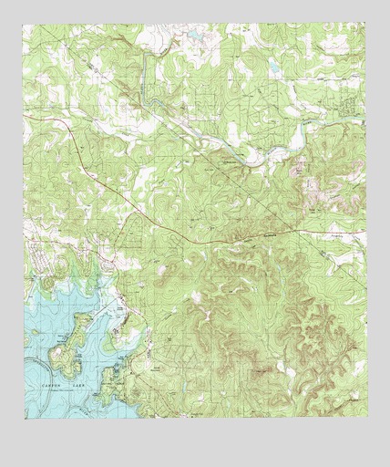
Devils Backbone, TX USGS Topographic Map
Click on map above to begin viewing in our Map Viewer.

This topographic map contains these locations and features:
Feature Name Type Latitude Longitude GNIS ID View Map
4 S Ranch AirportAirportN29.9588°W98.1865°2770623View Map
Baldy MountainSummitN29.8911°W98.1997°1372379View Map
Boy Scout DamDamN29.9552°W98.1686°1862883View Map
Boy Scout LakeReservoirN29.9598°W98.1743°1862884View Map
Canyon Lake AirportAirportN29.9201°W98.2458°1386344View Map
Canyon ParkParkN29.8933°W98.2350°2028655View Map
Carpers CreekStreamN29.9641°W98.1850°1372948View Map
Clear LakeReservoirN29.9862°W98.1584°1857386View Map
Clear Lake DamDamN29.9852°W98.1570°1857385View Map
Devils BackboneRidgeN29.9330°W98.1653°1373383View Map
Dutch BranchStreamN29.9622°W98.1764°1373507View Map
El Rancho CimaLocaleN29.9563°W98.1775°1373608View Map
Elm CreekStreamN29.9685°W98.1486°1373628View Map
Fort Sam Houston Recreation Area at Canyon LakeMilitaryN29.8889°W98.2182°2512219View Map
Hugo CemeteryCemeteryN29.9277°W98.1270°1374172View Map
Jacobs CreekStreamN29.8994°W98.2083°1374263View Map
Jacobs Creek ParkParkN29.8841°W98.2192°2029108View Map
Moon MountainSummitN29.9530°W98.1514°1374994View Map
Old Hancock TrailTrailN29.9183°W98.2253°2033319View Map
Pierce DamDamN29.9969°W98.1870°1857383View Map
Pierce LakeReservoirN29.9965°W98.1873°1857384View Map
Pinoak CreekStreamN29.9680°W98.1392°1375476View Map
Rancho Del Lago HeliportAirportN29.9519°W98.2247°1386632View Map
Randolph Recreation Area at Canyon LakeMilitaryN29.8828°W98.2179°2511990View Map
Shelton HollowValleyN29.9694°W98.1261°1376088View Map
Smith HollowValleyN29.9615°W98.1475°1376155View Map
Sorrel CreekStreamN29.9183°W98.2225°1376181View Map
Tower HillSummitN29.9402°W98.1433°1376481View Map

Note: Coordinates in the location and feature list above are referenced to NAD83 datum.


Copyright (C) 2008-2024 Ryan Niemi / Sunset Dynamics ... All Rights Reserved