TopoQuest Logo
Do you find TopoQuest useful?
Help keep TopoQuest running and adding new maps/features by donating!
Bitcoin:  19c7KJd3qBynnjoSw5npx9KScwjBe4ifkT
Litecoin:  LXs6TkuXGGXo1vDsWCkWVdjQX94eUKd6ui
Home View Maps Find Maps Find Places Resources & Links


Dexter, Georgia Topographic Map

USGS Map Title: Dexter, GA
USGS Map MRC: 32083D1
DRG (GeoTIFF) Download: o32083d1.tif


Neighboring USGS Topographic Map Quads:


  Danville East, GA  
32083E2
 

  Dudley, GA  
32083E1
 

  Dublin, GA  
32082E8
 

  Chester, GA  
32083D2
 

  Dexter, GA  
32083D1
 

  Rentz, GA  
32082D8
 

  Yonkers, GA  
32083C2
 

  Cadwell, GA  
32083C1
 

  Five Points, GA  
32082C8


Map MRC Location:

N33°
W84°
N33°
W83°
H8 H7 H6 H5 H4 H3 H2 H1
G8 G7 G6 G5 G4 G3 G2 G1
F8 F7 F6 F5 F4 F3 F2 F1
E8 E7 E6 E5 E4 E3 E2 E1
D8 D7 D6 D5 D4 D3 D2 D1
C8 C7 C6 C5 C4 C3 C2 C1
B8 B7 B6 B5 B4 B3 B2 B1
A8 A7 A6 A5 A4 A3 A2 A1
N32°
W84°
N32°
W83°

Dexter, GA USGS 1:24K Topographic Map Preview:
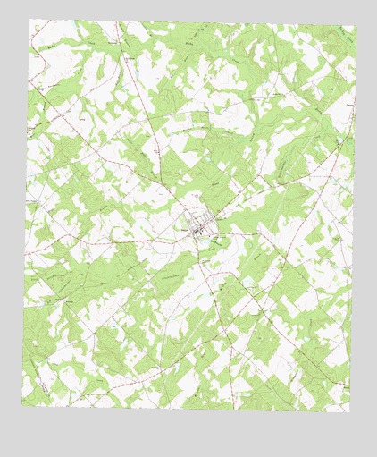
Dexter, GA USGS Topographic Map
Click on map above to begin viewing in our Map Viewer.

This topographic map contains these locations and features:
Feature Name Type Latitude Longitude GNIS ID View Map
AlcornsPopulated PlaceN32.4096°W83.1102°331010View Map
AlligoodPopulated PlaceN32.4363°W83.0040°326155View Map
Alligood CemeteryCemeteryN32.4310°W83.0049°310491View Map
Antioch Baptist ChurchChurchN32.4066°W83.0349°354339View Map
Bell BranchStreamN32.4899°W83.0907°311042View Map
Beulah Hill ChurchChurchN32.4774°W83.0268°354703View Map
Big BranchStreamN32.4921°W83.0626°311316View Map
Big Stitchihatchie BranchStreamN32.4182°W83.0924°311418View Map
Boggy BranchStreamN32.4657°W83.0365°354803View Map
Bryant School (historical)SchoolN32.4504°W83.1202°346498View Map
Buckhorn BridgeBridgeN32.4774°W83.1210°311980View Map
Buckhorn ChurchChurchN32.4643°W83.1246°354902View Map
Buckhorn CreekStreamN32.4913°W83.0990°311983View Map
Christian Science Tabernacle (historical)ChurchN32.4218°W83.1221°346513View Map
Collins BranchStreamN32.4954°W83.0757°312850View Map
DexterPopulated PlaceN32.4324°W83.0613°331543View Map
Dexter BranchStreamN32.4368°W83.0468°313461View Map
Dexter DivisionCivilN32.4386°W83.0606°1936225View Map
Dexter SchoolSchoolN32.4321°W83.0579°346525View Map
Dexter Volunteer Fire DepartmentBuildingN32.4318°W83.0625°2604473View Map
Duke Strip 2AirportN32.3818°W83.0586°2442685View Map
Five PointsPopulated PlaceN32.4416°W83.1202°326288View Map
Gin House BranchStreamN32.4288°W83.0493°314621View Map
Hill BridgeBridgeN32.4757°W83.0401°315409View Map
Hogans BranchStreamN32.4910°W83.0838°315518View Map
Kemp School (historical)SchoolN32.4671°W83.0551°346566View Map
KewaneePopulated PlaceN32.4935°W83.0902°332143View Map
Kewanee Church (historical)ChurchN32.4924°W83.0902°346567View Map
Little Boggy BranchStreamN32.4466°W83.0640°316957View Map
Little Rocky CreekStreamN32.4924°W83.0585°317178View Map
Little Stitchihatchie BranchStreamN32.4182°W83.0921°317207View Map
Lord LakeReservoirN32.4987°W83.1076°335891View Map
Lord Lake DamDamN32.4968°W83.1065°335890View Map
Lt LandingAirportN32.3784°W83.0875°2717252View Map
Malone LakeReservoirN32.3888°W83.0657°335899View Map
Malone Lake DamDamN32.3902°W83.0665°335898View Map
Mount Carmel CemeteryCemeteryN32.4229°W83.0579°318592View Map
Mount Carmel ChurchChurchN32.3882°W83.0721°318600View Map
Mount Carmel School (historical)SchoolN32.3993°W83.0985°346585View Map
Musgrove (historical)Populated PlaceN32.4171°W83.0899°346588View Map
NamelessPopulated PlaceN32.3871°W83.0721°346589View Map
Nameless School (historical)SchoolN32.3877°W83.0718°346590View Map
Nesmith LakeReservoirN32.3957°W83.0862°341109View Map
Nesmith Lake DamDamN32.3968°W83.0849°341108View Map
New Salem School (historical)SchoolN32.4393°W83.0085°346593View Map
Roberts BridgeBridgeN32.4638°W83.0035°321673View Map
Rocky Creek ChurchChurchN32.4871°W83.0874°321832View Map
Rocky Creek School (historical)SchoolN32.4879°W83.0815°346613View Map
Saint Lukes CemeteryCemeteryN32.4441°W83.0585°322151View Map
Scooter Route BranchStreamN32.4627°W83.0438°322641View Map
Shewmake Mill (historical)LocaleN32.4974°W83.0054°346621View Map
Shewmake SpringsSpringN32.4974°W83.0054°346622View Map
Spring Haven BridgeBridgeN32.4485°W83.0265°323403View Map
Springhaven (historical)Populated PlaceN32.4474°W83.0310°346628View Map
Stitchihatchie CreekStreamN32.4677°W83.0093°323632View Map
Town of DexterCivilN32.4331°W83.0596°2406378View Map
VincentPopulated PlaceN32.4735°W83.0004°333335View Map
Whitley BranchStreamN32.4360°W83.0374°325233View Map
Wide BranchStreamN32.4779°W83.1149°325248View Map
Wilkin School (historical)SchoolN32.4066°W83.0340°346651View Map

Note: Coordinates in the location and feature list above are referenced to NAD83 datum.


Copyright (C) 2008-2024 Ryan Niemi / Sunset Dynamics ... All Rights Reserved