TopoQuest Logo
Do you find TopoQuest useful?
Help keep TopoQuest running and adding new maps/features by donating!
Bitcoin:  19c7KJd3qBynnjoSw5npx9KScwjBe4ifkT
Litecoin:  LXs6TkuXGGXo1vDsWCkWVdjQX94eUKd6ui
Home View Maps Find Maps Find Places Resources & Links


Dudley, Georgia Topographic Map

USGS Map Title: Dudley, GA
USGS Map MRC: 32083E1
DRG (GeoTIFF) Download: o32083e1.tif


Neighboring USGS Topographic Map Quads:


  Stuckey Boone Lake, GA  
32083F2
 

  Nicklesville, GA  
32083F1
 

  Cow Hell Swamp, GA  
32082F8
 

  Danville East, GA  
32083E2
 

  Dudley, GA  
32083E1
 

  Dublin, GA  
32082E8
 

  Chester, GA  
32083D2
 

  Dexter, GA  
32083D1
 

  Rentz, GA  
32082D8


Map MRC Location:

N33°
W84°
N33°
W83°
H8 H7 H6 H5 H4 H3 H2 H1
G8 G7 G6 G5 G4 G3 G2 G1
F8 F7 F6 F5 F4 F3 F2 F1
E8 E7 E6 E5 E4 E3 E2 E1
D8 D7 D6 D5 D4 D3 D2 D1
C8 C7 C6 C5 C4 C3 C2 C1
B8 B7 B6 B5 B4 B3 B2 B1
A8 A7 A6 A5 A4 A3 A2 A1
N32°
W84°
N32°
W83°

Dudley, GA USGS 1:24K Topographic Map Preview:
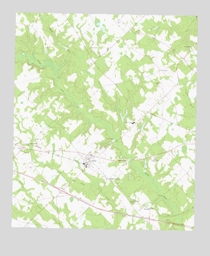
Dudley, GA USGS Topographic Map
Click on map above to begin viewing in our Map Viewer.

This topographic map contains these locations and features:
Feature Name Type Latitude Longitude GNIS ID View Map
Bender (historical)Populated PlaceN32.5502°W83.1213°346490View Map
Bird Hill ChurchChurchN32.5513°W83.1107°354736View Map
Chapel Hill School (historical)SchoolN32.5832°W83.1246°346511View Map
City of DudleyCivilN32.5321°W83.0805°2403513View Map
Dublin Memorial GardensCemeteryN32.5429°W83.0271°313693View Map
DudleyPopulated PlaceN32.5424°W83.0704°355563View Map
Dudley DivisionCivilN32.5369°W83.1237°1936233View Map
Dudley Fire DepartmentBuildingN32.5383°W83.0751°2604869View Map
Dudley SchoolSchoolN32.5407°W83.0729°346534View Map
Exit 12CrossingN32.5218°W83.0907°1705028View Map
Gilbert CemeteryCemeteryN32.6204°W83.0546°314587View Map
Haskins CemeteryCemeteryN32.5460°W83.1188°315223View Map
Haskins CrossingPopulated PlaceN32.5466°W83.1174°331925View Map
Heath CemeteryCemeteryN32.5439°W83.1168°315288View Map
Heath CemeteryCemeteryN32.5351°W83.1134°315290View Map
Hogan Grove ChurchChurchN32.5857°W83.0271°315516View Map
Hogan Lake DamDamN32.6185°W83.0282°335896View Map
Hogan School (historical)SchoolN32.5879°W83.0240°346557View Map
Horse BranchStreamN32.5513°W83.0543°315681View Map
Industrial School (historical)SchoolN32.6027°W83.0060°346560View Map
Laurens County Fire Department Station 3 Poplar SpringsBuildingN32.5991°W83.0101°2604489View Map
Lord LakeReservoirN32.5382°W83.0338°341246View Map
Lord Lake DamDamN32.5368°W83.0332°341245View Map
McDonald and Segars LakeReservoirN32.6175°W83.0288°335897View Map
McLees LakeReservoirN32.5599°W83.0362°335901View Map
McLees Lake DamDamN32.5585°W83.0365°335900View Map
Millville ChurchChurchN32.6054°W83.0718°318292View Map
New Hope ChurchChurchN32.6152°W83.0415°319397View Map
Northwest Laurens SchoolSchoolN32.5621°W83.0432°319706View Map
Oak Grove CemeteryCemeteryN32.6174°W83.0863°335305View Map
Oak Grove Church (historical)ChurchN32.6185°W83.0863°346596View Map
Olive Grove School (historical)SchoolN32.5696°W83.0229°346602View Map
Palmetto BranchStreamN32.5913°W83.0957°310354View Map
Pope CemeteryCemeteryN32.5463°W83.0935°321010View Map
Poplar Springs CemeteryCemeteryN32.6063°W83.0043°346607View Map
Poplar Springs North ChurchChurchN32.6063°W83.0035°321053View Map
Shadow Grove School (historical)SchoolN32.5063°W83.0338°346619View Map
Shady Grove ChurchChurchN32.5154°W83.0435°322755View Map
ShewmakePopulated PlaceN32.5141°W83.0346°326512View Map
Starlight ChurchChurchN32.5929°W83.0235°323529View Map
Thomas Cross RoadsLocaleN32.5849°W83.0557°346635View Map
Ussery CemeteryCemeteryN32.6104°W83.0490°324639View Map
Whipples CrossingPopulated PlaceN32.5293°W83.0585°326585View Map

Note: Coordinates in the location and feature list above are referenced to NAD83 datum.


Copyright (C) 2008-2024 Ryan Niemi / Sunset Dynamics ... All Rights Reserved