TopoQuest Logo
Do you find TopoQuest useful?
Help keep TopoQuest running and adding new maps/features by donating!
Bitcoin:  19c7KJd3qBynnjoSw5npx9KScwjBe4ifkT
Litecoin:  LXs6TkuXGGXo1vDsWCkWVdjQX94eUKd6ui
Home View Maps Find Maps Find Places Resources & Links


Woodland, Michigan Topographic Map

USGS Map Title: Woodland, MI
USGS Map MRC: 42085F2
DRG (GeoTIFF) Download: o42085f2.tif


Neighboring USGS Topographic Map Quads:


  Freeport, MI  
42085G3
 

  Lake Odessa, MI  
42085G2
 

  Woodbury, MI  
42085G1
 

  Hastings, MI  
42085F3
 

  Woodland, MI  
42085F2
 

  Saubee Lake, MI  
42085F1
 

  Dowling, MI  
42085E3
 

  Maple Grove, MI  
42085E2
 

  Nashville, MI  
42085E1


Map MRC Location:

N43°
W86°
N43°
W85°
H8 H7 H6 H5 H4 H3 H2 H1
G8 G7 G6 G5 G4 G3 G2 G1
F8 F7 F6 F5 F4 F3 F2 F1
E8 E7 E6 E5 E4 E3 E2 E1
D8 D7 D6 D5 D4 D3 D2 D1
C8 C7 C6 C5 C4 C3 C2 C1
B8 B7 B6 B5 B4 B3 B2 B1
A8 A7 A6 A5 A4 A3 A2 A1
N42°
W86°
N42°
W85°

Woodland, MI USGS 1:24K Topographic Map Preview:
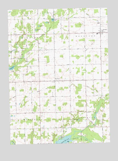
Woodland, MI USGS Topographic Map
Click on map above to begin viewing in our Map Viewer.

This topographic map contains these locations and features:
Feature Name Type Latitude Longitude GNIS ID View Map
Barnum Neighborhood CemeteryCemeteryN42.7189°W85.2111°2572239View Map
Brethren ChurchChurchN42.6836°W85.1278°621933View Map
Bullhead LakeLakeN42.7306°W85.2148°622231View Map
Charter Township of HastingsCivilN42.6377°W85.2441°1626449View Map
Coats GrovePopulated PlaceN42.6831°W85.1922°623516View Map
Coats Grove CemeteryCemeteryN42.6833°W85.1253°2572234View Map
Coats Grove Post Office (historical)Post OfficeN42.6831°W85.1922°2572386View Map
Coats Grove Station (historical)LocaleN42.6814°W85.1919°2572692View Map
Fisher SchoolSchoolN42.6545°W85.2225°626074View Map
Free ChurchChurchN42.6534°W85.1539°626448View Map
Fuller CemeteryCemeteryN42.7181°W85.2117°626551View Map
Gerkey Post Office (historical)Post OfficeN42.7417°W85.2117°2572380View Map
Gravel BrookStreamN42.6653°W85.1292°627239View Map
Huckleberry LakeLakeN42.7343°W85.2115°628759View Map
Lakeview SchoolSchoolN42.6389°W85.1889°630064View Map
Lawhead LakeLakeN42.7397°W85.1936°630205View Map
Little Thornapple RiverStreamN42.7139°W85.2281°630790View Map
Lower LakeLakeN42.6959°W85.2461°631174View Map
Martin SchoolSchoolN42.6536°W85.1725°631671View Map
Mud CreekStreamN42.6325°W85.1733°632875View Map
Pumpkin Seed LakeLakeN42.6470°W85.1636°635516View Map
Ragla SchoolSchoolN42.6981°W85.2269°635593View Map
Scott LakeLakeN42.7378°W85.2006°2105373View Map
Stoney Point ChurchChurchN42.6536°W85.1539°2105371View Map
Township of CastletonCivilN42.6398°W85.1336°1626044View Map
Township of WoodlandCivilN42.7269°W85.1337°1627289View Map
Village of WoodlandCivilN42.7271°W85.1352°2399733View Map
Warner CemeteryCemeteryN42.6534°W85.1528°1615770View Map
Wood Grove ChurchChurchN42.6828°W85.1928°2105372View Map
WoodlandPopulated PlaceN42.7267°W85.1336°1616751View Map
Woodland Elementary SchoolSchoolN42.7264°W85.1383°2572740View Map
Woodland Post OfficePost OfficeN42.7278°W85.1336°2572743View Map
Woodland Station (historical)LocaleN42.7236°W85.1344°2572739View Map
Woodland Town Hall Historical MarkerParkN42.7272°W85.1316°2564500View Map
Woodland Township Fire DepartmentBuildingN42.7263°W85.1347°2572741View Map
Woodland Township LibraryBuildingN42.7289°W85.1336°2572742View Map
Woodland Township Police DepartmentBuildingN42.7263°W85.1346°2737607View Map
Woodland United Methodist ChurchChurchN42.7294°W85.1344°2572744View Map

Note: Coordinates in the location and feature list above are referenced to NAD83 datum.


Copyright (C) 2008-2025 Ryan Niemi / Sunset Dynamics ... All Rights Reserved