TopoQuest Logo
Do you find TopoQuest useful?
Help keep TopoQuest running and adding new maps/features by donating!
Bitcoin:  19c7KJd3qBynnjoSw5npx9KScwjBe4ifkT
Litecoin:  LXs6TkuXGGXo1vDsWCkWVdjQX94eUKd6ui
Home View Maps Find Maps Find Places Resources & Links


Maple Grove, Michigan Topographic Map

USGS Map Title: Maple Grove, MI
USGS Map MRC: 42085E2
DRG (GeoTIFF) Download: o42085e2.tif


Neighboring USGS Topographic Map Quads:


  Hastings, MI  
42085F3
 

  Woodland, MI  
42085F2
 

  Saubee Lake, MI  
42085F1
 

  Dowling, MI  
42085E3
 

  Maple Grove, MI  
42085E2
 

  Nashville, MI  
42085E1
 

  Banfield, MI  
42085D3
 

  Bedford, MI  
42085D2
 

  Bellevue, MI  
42085D1


Map MRC Location:

N43°
W86°
N43°
W85°
H8 H7 H6 H5 H4 H3 H2 H1
G8 G7 G6 G5 G4 G3 G2 G1
F8 F7 F6 F5 F4 F3 F2 F1
E8 E7 E6 E5 E4 E3 E2 E1
D8 D7 D6 D5 D4 D3 D2 D1
C8 C7 C6 C5 C4 C3 C2 C1
B8 B7 B6 B5 B4 B3 B2 B1
A8 A7 A6 A5 A4 A3 A2 A1
N42°
W86°
N42°
W85°

Maple Grove, MI USGS 1:24K Topographic Map Preview:
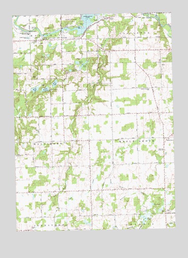
Maple Grove, MI USGS Topographic Map
Click on map above to begin viewing in our Map Viewer.

This topographic map contains these locations and features:
Feature Name Type Latitude Longitude GNIS ID View Map
Barry County Christian SchoolSchoolN42.6103°W85.2361°2572725View Map
Barry County Extended Care FacilityHospitalN42.6142°W85.2375°2109224View Map
Barry County Poor Farm CemeteryCemeteryN42.6158°W85.2422°2572228View Map
Barry's Resort and Mobile Home ParkPopulated PlaceN42.6128°W85.2103°2572724View Map
Barryville CemeteryCemeteryN42.6042°W85.1728°2572235View Map
Barryville Historical MarkerParkN42.6036°W85.1727°2564483View Map
Barryville Post Office (historical)Post OfficeN42.6036°W85.1833°2572394View Map
Barryville SchoolSchoolN42.6039°W85.1639°620653View Map
Branch SchoolSchoolN42.5839°W85.1742°621882View Map
Brethren ChurchChurchN42.5661°W85.2217°621932View Map
Camp KitanniwaLocaleN42.5823°W85.2219°622590View Map
Cedar CreekStreamN42.6136°W85.2283°622901View Map
Charlton ParkParkN42.6186°W85.2042°623119View Map
Dunhan SchoolSchoolN42.5231°W85.1831°624995View Map
Durfee SchoolSchoolN42.5517°W85.2217°625023View Map
Ellis LakeLakeN42.5109°W85.1365°625488View Map
Ellison LakeLakeN42.5970°W85.1997°625493View Map
German Evangelical CemeteryCemeteryN42.5817°W85.1433°2109223View Map
Gregory LakeLakeN42.5925°W85.2052°627407View Map
Hall LakeLakeN42.5853°W85.2176°627645View Map
Hastings Township CemeteryCemeteryN42.6178°W85.2357°1615020View Map
High Bank CreekStreamN42.6245°W85.1819°628224View Map
Highbank Post Office (historical)Post OfficeN42.5519°W85.2106°2572377View Map
Indian Landing-Charlton Park Historical MarkerParkN42.6196°W85.2035°2564493View Map
Laurel Manor Rest HomeBuildingN42.5672°W85.1500°2572761View Map
Long LakeLakeN42.5956°W85.1951°630925View Map
Maple GrovePopulated PlaceN42.5522°W85.1289°2109222View Map
Maple Grove Post Office (historical)Post OfficeN42.5522°W85.1292°2572372View Map
Maple Leaf Grange HallBuildingN42.5456°W85.1333°2109221View Map
McKelvey SchoolSchoolN42.5811°W85.1400°631940View Map
Middle LakeLakeN42.5819°W85.2253°632260View Map
Mills SchoolSchoolN42.5181°W85.2167°632428View Map
Mixer LakeLakeN42.5821°W85.2333°632530View Map
Moore SchoolSchoolN42.5514°W85.1725°632652View Map
MorganPopulated PlaceN42.6225°W85.1764°632682View Map
Morgan Post Office (historical)Post OfficeN42.6225°W85.1764°2572371View Map
Morgan Station (historical)LocaleN42.6228°W85.1764°2572688View Map
Peace United Methodist ChurchChurchN42.6039°W85.1722°2572760View Map
Pratt SchoolSchoolN42.6248°W85.2219°635407View Map
Quimby Post Office (historical)Post OfficeN42.6103°W85.2278°2572364View Map
Quimby Station (historical)LocaleN42.6108°W85.2278°2572686View Map
Quimby United Methodist ChurchChurchN42.6103°W85.2278°2572723View Map
QumbyPopulated PlaceN42.6103°W85.2278°635576View Map
Rivergate Family CampgroundLocaleN42.6167°W85.2133°2572722View Map
Squaw BrookStreamN42.5200°W85.1614°2109219View Map
Striker CemeteryCemeteryN42.5892°W85.2317°638959View Map
Striker SchoolSchoolN42.5875°W85.2219°638960View Map
Taylor LakeLakeN42.5041°W85.1499°1614628View Map
Thornapple LakeLakeN42.6238°W85.1879°1614794View Map
Thornapple Lake Estates Mobile Home ParkPopulated PlaceN42.6236°W85.1800°2572759View Map
Township of BaltimoreCivilN42.5518°W85.2498°1625877View Map
Township of Maple GroveCivilN42.5525°W85.1330°1626674View Map
Union CemeteryCemeteryN42.5086°W85.1900°1615331View Map
Wild LakeLakeN42.5144°W85.1424°2109220View Map

Note: Coordinates in the location and feature list above are referenced to NAD83 datum.


Copyright (C) 2008-2025 Ryan Niemi / Sunset Dynamics ... All Rights Reserved