TopoQuest Logo
Do you find TopoQuest useful?
Help keep TopoQuest running and adding new maps/features by donating!
Bitcoin:  19c7KJd3qBynnjoSw5npx9KScwjBe4ifkT
Litecoin:  LXs6TkuXGGXo1vDsWCkWVdjQX94eUKd6ui
Home View Maps Find Maps Find Places Resources & Links


Elmo, Wyoming Topographic Map

USGS Map Title: Elmo, WY
USGS Map MRC: 41106H5
DRG (GeoTIFF) Download: o41106h5.tif


Neighboring USGS Topographic Map Quads:


  Schneider Ridge, WY  
42106A6
 

  T E Ranch, WY  
42106A5
 

  Difficulty, WY  
42106A4
 

  Tenmile Spring, WY  
41106H6
 

  Elmo, WY  
41106H5
 

  Como West, WY  
41106H4
 

  Dana, WY  
41106G6
 

  Hanna, WY  
41106G5
 

  Carbon, WY  
41106G4


Map MRC Location:

N42°
W107°
N42°
W106°
H8 H7 H6 H5 H4 H3 H2 H1
G8 G7 G6 G5 G4 G3 G2 G1
F8 F7 F6 F5 F4 F3 F2 F1
E8 E7 E6 E5 E4 E3 E2 E1
D8 D7 D6 D5 D4 D3 D2 D1
C8 C7 C6 C5 C4 C3 C2 C1
B8 B7 B6 B5 B4 B3 B2 B1
A8 A7 A6 A5 A4 A3 A2 A1
N41°
W107°
N41°
W106°

Elmo, WY USGS 1:24K Topographic Map Preview:
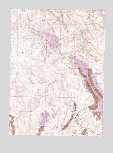
Elmo, WY USGS Topographic Map
Click on map above to begin viewing in our Map Viewer.

This topographic map contains these locations and features:
Feature Name Type Latitude Longitude GNIS ID View Map
Antelope DamDamN41.9000°W106.5006°1608444View Map
Antelope ReservoirReservoirN41.9000°W106.5006°1608445View Map
Barrel SpringSpringN41.9386°W106.5050°1585150View Map
Barrel Springs DrawValleyN41.9605°W106.5320°1585159View Map
ElmoPopulated PlaceN41.8789°W106.5361°1588275View Map
Elmo Peacock MineMineN41.8819°W106.5350°1726034View Map
Hanna and Dravo MineMineN41.9205°W106.5464°1726036View Map
Hanna Number One Strip MineMineN41.8880°W106.5445°1726035View Map
McMillen MineMineN41.8936°W106.5417°1726037View Map
Medicine Bow BreaksRangeN41.9861°W106.5711°1591447View Map
Nugget MineMineN41.8952°W106.5059°1726038View Map
Red Mountain MineMineN41.8952°W106.5445°1726039View Map
Rosebud Pit Number EightMineN41.9383°W106.5294°1726042View Map
Rosebud Pit Number FiveMineN41.9192°W106.5094°1726041View Map
Rosebud Pit Number ThreeMineN41.8881°W106.5439°1726040View Map
Rosebud Strip MineMineN41.9041°W106.5103°1726056View Map
Seminoe Number Two MineMineN41.9027°W106.5131°1726055View Map
Willow Spring DrawValleyN41.9422°W106.5431°1596482View Map

Note: Coordinates in the location and feature list above are referenced to NAD83 datum.


Copyright (C) 2008-2025 Ryan Niemi / Sunset Dynamics ... All Rights Reserved