TopoQuest Logo
Do you find TopoQuest useful?
Help keep TopoQuest running and adding new maps/features by donating!
Bitcoin:  19c7KJd3qBynnjoSw5npx9KScwjBe4ifkT
Litecoin:  LXs6TkuXGGXo1vDsWCkWVdjQX94eUKd6ui
Home View Maps Find Maps Find Places Resources & Links


Church Hill, Maryland Topographic Map

USGS Map Title: Church Hill, MD
USGS Map MRC: 39075B8
DRG (GeoTIFF) Download: o39075b8.tif


Neighboring USGS Topographic Map Quads:


  Betterton, MD  
39076C1
 

  Galena, MD  
39075C8
 

  Millington, MD  
39075C7
 

  Chestertown, MD  
39076B1
 

  Church Hill, MD  
39075B8
 

  Sudlersville, MD  
39075B7
 

  Centreville, MD  
39076A1
 

  Price, MD  
39075A8
 

  Goldsboro, MD  
39075A7


Map MRC Location:

N40°
W76°
N40°
W75°
H8 H7 H6 H5 H4 H3 H2 H1
G8 G7 G6 G5 G4 G3 G2 G1
F8 F7 F6 F5 F4 F3 F2 F1
E8 E7 E6 E5 E4 E3 E2 E1
D8 D7 D6 D5 D4 D3 D2 D1
C8 C7 C6 C5 C4 C3 C2 C1
B8 B7 B6 B5 B4 B3 B2 B1
A8 A7 A6 A5 A4 A3 A2 A1
N39°
W76°
N39°
W75°

Church Hill, MD USGS 1:24K Topographic Map Preview:
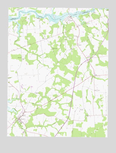
Church Hill, MD USGS Topographic Map
Click on map above to begin viewing in our Map Viewer.

This topographic map contains these locations and features:
Feature Name Type Latitude Longitude GNIS ID View Map
Ben Lee EstatesPopulated PlaceN39.1604°W75.9258°596041View Map
Benton CornersLocaleN39.1696°W75.8913°597073View Map
Bethel ChurchChurchN39.2098°W75.9211°597080View Map
Bethel Church CemeteryCemeteryN39.2093°W75.9216°596042View Map
Birres CreekStreamN39.2471°W75.9136°593900View Map
Bluff PointCapeN39.2429°W75.9472°593901View Map
Boyer ChapelChurchN39.1990°W75.9819°597109View Map
Callisters Ferry (historical)CrossingN39.2448°W75.9247°598378View Map
Cassinelli Vineyards and WineryBuildingN39.1300°W75.9975°2704598View Map
Char-Nor ManorPopulated PlaceN39.2387°W75.9852°596047View Map
Chase IslandIslandN39.2415°W75.9422°583707View Map
Chesterville BranchStreamN39.2443°W75.9288°595206View Map
Church HillPopulated PlaceN39.1412°W75.9855°597247View Map
Church Hill Elementary SchoolSchoolN39.1475°W75.9808°596049View Map
Church Hill FarmsLocaleN39.1537°W75.9549°596050View Map
Church Hill Post Office (historical)Post OfficeN39.1423°W75.9855°596051View Map
Church Hill Town HallBuildingN39.1417°W75.9850°2503203View Map
Church Hill United Methodist ChurchChurchN39.1384°W75.9824°596052View Map
Church Hill Volunteer Fire Company Station 5BuildingN39.1414°W75.9857°2085768View Map
CronshawPopulated PlaceN39.1468°W75.9816°596054View Map
CrumptonPopulated PlaceN39.2415°W75.9216°597301View Map
Crumpton CemeteryCemeteryN39.2331°W75.9125°597302View Map
Crumpton ParkParkN39.2373°W75.9172°596055View Map
Crumpton Post OfficePost OfficeN39.2404°W75.9218°596056View Map
Crumpton Seniors CenterBuildingN39.2373°W75.9174°596057View Map
Crumpton United Methodist ChurchChurchN39.2409°W75.9227°596058View Map
Crumpton Volunteer Fire Department Station 7BuildingN39.2392°W75.9257°2085742View Map
Deep LandingPopulated PlaceN39.2404°W75.9599°597319View Map
District 2, Church HillCivilN39.1418°W75.9777°1929526View Map
District 7, CrumptonCivilN39.2195°W75.9317°1929671View Map
Dogwood LodgeLocaleN39.2437°W75.9011°596059View Map
Double Creek CemeteryCemeteryN39.2104°W75.9277°596060View Map
Double Creek ChurchChurchN39.2101°W75.9438°597341View Map
Double Creek WoodPopulated PlaceN39.2401°W75.9786°596061View Map
Ducks Neck CampgroundLocaleN39.2376°W75.9749°596062View Map
Dudley CornersPopulated PlaceN39.1840°W75.8919°597353View Map
Dudleys ChapelChurchN39.1823°W75.8924°596063View Map
Eastern Shore Academy of the Seventh Day AdventistsSchoolN39.1934°W75.8958°596064View Map
EwingvillePopulated PlaceN39.2009°W75.9824°597384View Map
Flying Acres AirportAirportN39.1807°W75.9088°598359View Map
Ford LandingPopulated PlaceN39.2462°W75.8944°597406View Map
Foreman BranchStreamN39.2379°W75.9913°597407View Map
Goosehaven CreekStreamN39.2468°W75.9663°593904View Map
Home Missionary ChurchChurchN39.2271°W75.9283°596067View Map
Jeffers Chapel United Methodist ChurchChurchN39.1843°W75.8913°596068View Map
Kingdom Hall of Jehovahs WitnessesChurchN39.2196°W75.9522°596071View Map
Kirby LandingPopulated PlaceN39.2493°W75.8755°597644View Map
McGinnesPopulated PlaceN39.2196°W75.9519°597735View Map
Mount Pleasant ChurchChurchN39.2218°W75.9127°597784View Map
Mount Pleasant Methodist CemeteryCemeteryN39.2222°W75.9133°596077View Map
Mussel ShoalsPopulated PlaceN39.2404°W75.9191°596078View Map
Newmans CornerPopulated PlaceN39.1662°W75.9666°597807View Map
Norris CreekStreamN39.2426°W75.9552°593911View Map
Pearl CreekStreamN39.2373°W75.9324°597886View Map
PheasantfieldPopulated PlaceN39.2404°W75.9758°596081View Map
Pine CovePopulated PlaceN39.2390°W75.9594°596082View Map
Pine Springs Mobile Home ParkPopulated PlaceN39.2357°W75.9252°596083View Map
Piney ShoresPopulated PlaceN39.2368°W75.9302°596085View Map
Pinkney ParkParkN39.2248°W75.9124°596086View Map
PondtownPopulated PlaceN39.2140°W75.9130°597910View Map
Pondtown School (historical)SchoolN39.2215°W75.9136°596087View Map
Prickly Pear CreekStreamN39.2440°W75.9436°593913View Map
Queen Annes County LandfillLocaleN39.1293°W75.9797°596090View Map
Red Lion BranchStreamN39.2421°W75.9133°597948View Map
Roseland AirportAirportN39.1892°W75.8763°2443769View Map
Rowsbys BranchStreamN39.2048°W75.8891°596096View Map
SagefieldPopulated PlaceN39.1834°W75.8855°596098View Map
Saint Lukes ChurchChurchN39.1421°W75.9863°596101View Map
Spring LandingAirportN39.2449°W75.8830°2443764View Map
SpringviewPopulated PlaceN39.2368°W75.8897°596102View Map
Spry LandingPopulated PlaceN39.2440°W75.9527°591340View Map
Stevens CornerPopulated PlaceN39.1448°W75.8983°598120View Map
Sutton PointCapeN39.2379°W75.9355°598138View Map
The MeadowsPopulated PlaceN39.1507°W75.9799°596107View Map
The Village at Church Hill CrossingPopulated PlaceN39.1440°W75.9852°596108View Map
Thomas CemeteryCemeteryN39.2100°W75.9873°598162View Map
Town of Church HillCivilN39.1450°W75.9807°2390795View Map
Travilla WharfLocaleN39.2479°W75.9858°587868View Map
WeidmanPopulated PlaceN39.1509°W75.9094°598229View Map

Note: Coordinates in the location and feature list above are referenced to NAD83 datum.


Copyright (C) 2008-2024 Ryan Niemi / Sunset Dynamics ... All Rights Reserved