TopoQuest Logo
Do you find TopoQuest useful?
Help keep TopoQuest running and adding new maps/features by donating!
Bitcoin:  19c7KJd3qBynnjoSw5npx9KScwjBe4ifkT
Litecoin:  LXs6TkuXGGXo1vDsWCkWVdjQX94eUKd6ui
Home View Maps Find Maps Find Places Resources & Links


Shoals, Oklahoma Topographic Map

USGS Map Title: Shoals, OK
USGS Map MRC: 33095H4
DRG (GeoTIFF) Download: o33095h4.tif


Neighboring USGS Topographic Map Quads:


  Hugo, OK  
34095A5
 

  Hugo Dam, OK  
34095A4
 

  Fort Towson, OK  
34095A3
 

  Grant, OK  
33095H5
 

  Shoals, OK  
33095H4
 

  Frogville, OK  
33095H3
 

  Pat Mayse Lake East, TX  
33095G5
 

  Slate Shoals, TX  
33095G4
 

  Woodland, TX  
33095G3


Map MRC Location:

N34°
W96°
N34°
W95°
H8 H7 H6 H5 H4 H3 H2 H1
G8 G7 G6 G5 G4 G3 G2 G1
F8 F7 F6 F5 F4 F3 F2 F1
E8 E7 E6 E5 E4 E3 E2 E1
D8 D7 D6 D5 D4 D3 D2 D1
C8 C7 C6 C5 C4 C3 C2 C1
B8 B7 B6 B5 B4 B3 B2 B1
A8 A7 A6 A5 A4 A3 A2 A1
N33°
W96°
N33°
W95°

Shoals, OK USGS 1:24K Topographic Map Preview:
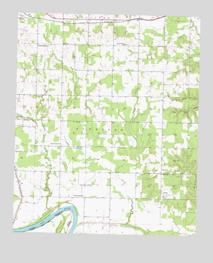
Shoals, OK USGS Topographic Map
Click on map above to begin viewing in our Map Viewer.

This topographic map contains these locations and features:
Feature Name Type Latitude Longitude GNIS ID View Map
Bearden Springs SchoolSchoolN33.9820°W95.4813°1089920View Map
Bethel ChurchChurchN33.9829°W95.4686°1090043View Map
Choctaw County Ambulance AuthorityBuildingN33.9941°W95.4902°2695855View Map
Durant CemeteryCemeteryN33.9146°W95.4503°1092308View Map
Ervin SchoolSchoolN33.9543°W95.3988°1092636View Map
FallonPopulated PlaceN33.9979°W95.4169°1100404View Map
Grant CemeteryCemeteryN33.9398°W95.4975°1093318View Map
Horse CreekStreamN33.8862°W95.4725°1093934View Map
Horse Prairie SchoolSchoolN33.9259°W95.4686°1093943View Map
Jones CemeteryCemeteryN33.9765°W95.4491°1094258View Map
KITX-FM (Hugo)TowerN33.9157°W95.4680°1102805View Map
Lone Elm SchoolSchoolN33.9387°W95.4533°1094901View Map
Mount Olivet CemeteryCemeteryN33.9981°W95.4997°1089496View Map
Oknoname 023003 DamDamN33.9184°W95.4886°1756126View Map
Oknoname 023003 ReservoirReservoirN33.9184°W95.4886°1756127View Map
OrdPopulated PlaceN33.9101°W95.4994°1100703View Map
Owl CreekStreamN33.9087°W95.4761°1096365View Map
Pleasant Hill CemeteryCemeteryN33.9250°W95.4678°2723912View Map
ShoalsPopulated PlaceN33.8979°W95.3977°1098004View Map
Shoals CemeteryCemeteryN33.9108°W95.4000°2723917View Map
Shoals Chapel SchoolSchoolN33.8962°W95.4563°1098005View Map
Shoals ChurchChurchN33.9123°W95.3994°1098006View Map
Shoals SchoolSchoolN33.9101°W95.3994°1098007View Map
Shoat Lake SchoolSchoolN33.9026°W95.4527°1098009View Map
Shoat Springs CemeteryCemeteryN33.9738°W95.4173°1098011View Map
Shoat Springs SchoolSchoolN33.9832°W95.4258°1098012View Map
Township of EveridgeCivilN33.9140°W95.4641°1824696View Map

Note: Coordinates in the location and feature list above are referenced to NAD83 datum.


Copyright (C) 2008-2025 Ryan Niemi / Sunset Dynamics ... All Rights Reserved