TopoQuest Logo
Do you find TopoQuest useful?
Help keep TopoQuest running and adding new maps/features by donating!
Bitcoin:  19c7KJd3qBynnjoSw5npx9KScwjBe4ifkT
Litecoin:  LXs6TkuXGGXo1vDsWCkWVdjQX94eUKd6ui
Home View Maps Find Maps Find Places Resources & Links


Guys, Tennessee Topographic Map

USGS Map Title: Guys, TN
USGS Map MRC: 35088A5
DRG (GeoTIFF) Download: o35088a5.tif


Neighboring USGS Topographic Map Quads:


  Rose Creek, TN  
35088B6
 

  Purdy, TN  
35088B5
 

  Stantonville, TN  
35088B4
 

  Chewalla, TN  
35088A6
 

  Guys, TN  
35088A5
 

  Michie, TN  
35088A4
 

  Kossuth North, MS  
34088H6
 

  Corinth, MS  
34088H5
 

  Kendrick, MS  
34088H4


Map MRC Location:

N36°
W89°
N36°
W88°
H8 H7 H6 H5 H4 H3 H2 H1
G8 G7 G6 G5 G4 G3 G2 G1
F8 F7 F6 F5 F4 F3 F2 F1
E8 E7 E6 E5 E4 E3 E2 E1
D8 D7 D6 D5 D4 D3 D2 D1
C8 C7 C6 C5 C4 C3 C2 C1
B8 B7 B6 B5 B4 B3 B2 B1
A8 A7 A6 A5 A4 A3 A2 A1
N35°
W89°
N35°
W88°

Guys, TN USGS 1:24K Topographic Map Preview:
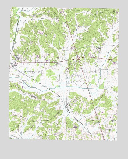
Guys, TN USGS Topographic Map
Click on map above to begin viewing in our Map Viewer.

This topographic map contains these locations and features:
Feature Name Type Latitude Longitude GNIS ID View Map
Adams Chapel SchoolSchoolN35.0406°W88.5950°1275466View Map
Berua ChurchChurchN35.0423°W88.5987°1277069View Map
Brushy BranchStreamN35.0501°W88.5442°1278693View Map
City of RamerCivilN35.0717°W88.6152°2404591View Map
Damron CemeteryCemeteryN35.0673°W88.5514°1281999View Map
EastviewPopulated PlaceN35.0756°W88.5453°1283436View Map
Eastview Volunteer Fire DepartmentBuildingN35.0789°W88.5485°2653937View Map
Eastview-Ramer Division (historical)CensusN35.0631°W88.5923°1648845View Map
Gravel HillPopulated PlaceN35.0868°W88.5245°1285928View Map
Gravel Hill Baptist ChurchChurchN35.0868°W88.5245°1320093View Map
Gravel Hill CemeteryCemeteryN35.0867°W88.5256°1308665View Map
Gravel Hill School (historical)SchoolN35.0812°W88.5234°1320094View Map
GuysPopulated PlaceN35.0348°W88.5587°1286465View Map
Guys Post OfficePost OfficeN35.0321°W88.5578°1649724View Map
Guys School (historical)SchoolN35.0351°W88.5567°1320095View Map
Guys Volunteer Fire DepartmentBuildingN35.0319°W88.5545°2653939View Map
Houston CemeteryCemeteryN35.0312°W88.5542°1288504View Map
Houston CemeteryCemeteryN35.0584°W88.5589°1288505View Map
Little Muddy CreekStreamN35.0501°W88.5687°1291591View Map
Lorraine CemeteryCemeteryN35.0195°W88.5034°1308687View Map
Lorraine ChurchChurchN35.0190°W88.5028°1292064View Map
Mount Olive ChurchChurchN35.0662°W88.5514°1294697View Map
Mount Vernon CemeteryCemeteryN35.0706°W88.5712°1308710View Map
Mount Vernon ChurchChurchN35.0715°W88.5720°1294823View Map
Olive Hill CemeteryCemeteryN35.0179°W88.5970°1308724View Map
Olive Hill ChurchChurchN35.0176°W88.5975°1296411View Map
Oxford CreekStreamN35.1229°W88.6156°1296620View Map
Pleasant Grove CemeteryCemeteryN35.1115°W88.5603°1297802View Map
Prairie BranchStreamN35.0540°W88.6078°1298440View Map
RamerPopulated PlaceN35.0695°W88.6223°1298872View Map
Ramer Baptist ChurchChurchN35.0720°W88.6175°1326708View Map
Ramer CemeteryCemeteryN35.0776°W88.6184°1298874View Map
Ramer Elementary SchoolSchoolN35.0723°W88.6184°1308734View Map
Ramer Fire DepartmentBuildingN35.0711°W88.6200°2653807View Map
Ramer Post OfficePost OfficeN35.0706°W88.6199°1649735View Map
Roland CreekStreamN35.0504°W88.5667°1300025View Map
Rosenwald SchoolSchoolN35.0790°W88.6167°1300104View Map
Saint Rest ChurchChurchN35.0101°W88.5084°1300519View Map
Saint Rest SchoolSchoolN35.0190°W88.5275°1300520View Map
Town of EastviewCivilN35.0868°W88.5514°2406417View Map
Town of GuysCivilN35.0193°W88.5415°2406634View Map
Wades ChapelChurchN35.0776°W88.6170°1273524View Map
Wolf BranchStreamN35.1043°W88.6139°1274927View Map

Note: Coordinates in the location and feature list above are referenced to NAD83 datum.


Copyright (C) 2008-2025 Ryan Niemi / Sunset Dynamics ... All Rights Reserved