TopoQuest Logo
Do you find TopoQuest useful?
Help keep TopoQuest running and adding new maps/features by donating!
Bitcoin:  19c7KJd3qBynnjoSw5npx9KScwjBe4ifkT
Litecoin:  LXs6TkuXGGXo1vDsWCkWVdjQX94eUKd6ui
Home View Maps Find Maps Find Places Resources & Links


Chincoteague West, Virginia Topographic Map

USGS Map Title: Chincoteague West, VA
USGS Map MRC: 37075H4
DRG (GeoTIFF) Download: o37075h4.tif


Neighboring USGS Topographic Map Quads:


  Pocomoke City, MD  
38075A5
 

  Girdletree, MD  
38075A4
 

  Boxiron, MD  
38075A3
 

  Hallwood, VA  
37075H5
 

  Chincoteague West, VA  
37075H4
 

  Chincoteague East, VA  
37075H3
 

  Bloxom, VA  
37075G5
 

  Wallops Island, VA  
37075G4


Map MRC Location:

N38°
W76°
N38°
W75°
H8 H7 H6 H5 H4 H3 H2 H1
G8 G7 G6 G5 G4 G3 G2 G1
F8 F7 F6 F5 F4 F3 F2 F1
E8 E7 E6 E5 E4 E3 E2 E1
D8 D7 D6 D5 D4 D3 D2 D1
C8 C7 C6 C5 C4 C3 C2 C1
B8 B7 B6 B5 B4 B3 B2 B1
A8 A7 A6 A5 A4 A3 A2 A1
N37°
W76°
N37°
W75°

Chincoteague West, VA USGS 1:24K Topographic Map Preview:
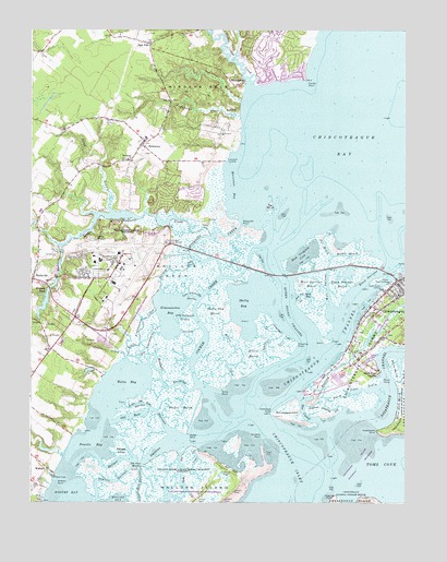
Chincoteague West, VA USGS Topographic Map
Click on map above to begin viewing in our Map Viewer.

This topographic map contains these locations and features:
Feature Name Type Latitude Longitude GNIS ID View Map
Andrews and Daisey CemeteryCemeteryN37.9198°W75.3903°2780414View Map
Andrews Landing GutGutN37.9010°W75.4013°1462472View Map
Assateague PointCapeN37.8940°W75.3846°1462603View Map
Aydelotte - Booth-Whealton CemeteryCemeteryN37.9285°W75.3807°2780408View Map
Ballast NarrowsGutN37.8860°W75.4649°1462742View Map
Ballast TumpIslandN37.8887°W75.4696°1462743View Map
Beulah Baptist Church CemeteryCemeteryN37.9247°W75.3853°2780412View Map
Big Simoneaston CreekStreamN37.9132°W75.4685°1463407View Map
Black Duck CreekStreamN37.9046°W75.3780°1463481View Map
Black NarrowsGutN37.9343°W75.3877°1463490View Map
Black Narrows MarshSwampN37.9326°W75.3973°1463491View Map
Black PointCapeN37.9076°W75.3824°1463495View Map
Black Point DrainGutN37.9048°W75.3891°1463496View Map
Black Point LandingPopulated PlaceN37.9096°W75.3833°1492583View Map
Bunting CemeteryCemeteryN37.9251°W75.3848°2780411View Map
Captain's Cove Golf and Yacht ClubLocaleN37.9949°W75.4216°2520149View Map
Captains CovePopulated PlaceN37.9900°W75.4227°2507992View Map
Cedar CreekStreamN37.9135°W75.4691°1464597View Map
ChincoteaguePopulated PlaceN37.9332°W75.3788°1492764View Map
Chincoteague ChannelChannelN37.9162°W75.3991°1464857View Map
Chincoteague InletChannelN37.8846°W75.4119°1480088View Map
Chincoteague National Wildlife RefugeParkN37.8946°W75.3781°1464861View Map
Chincoteague PointCapeN37.8985°W75.4146°1464862View Map
Chincoteague Pumping StationLocaleN37.9437°W75.4555°1491127View Map
Chincoteague Volunteer Fire CompanyBuildingN37.9332°W75.3782°2075654View Map
Christ Union Baptist Church CemeteryCemeteryN37.9264°W75.3833°2780409View Map
Clark CemeteryCemeteryN37.9305°W75.3760°2780421View Map
Cockle CreekStreamN37.9054°W75.4424°1465039View Map
Cockle PointCapeN37.9865°W75.4080°1465040View Map
Coldkall CreekStreamN37.9776°W75.4305°1465070View Map
Cow GutGutN37.8873°W75.4446°1465341View Map
Cow Gut FlatFlatN37.8837°W75.4330°1465342View Map
Daisey CemeteryCemeteryN37.9144°W75.3892°2780415View Map
Dees ChurchChurchN37.9815°W75.4530°1465723View Map
District 2CivilN37.8847°W75.4667°1927196View Map
Doghead FlatFlatN37.9193°W75.4158°1465872View Map
Dublin FarmsLocaleN37.9550°W75.4669°2676092View Map
Egg MarshSwampN37.9526°W75.4205°1466197View Map
Far MouthGutN37.9429°W75.4016°1466484View Map
Fishing PointCapeN37.8776°W75.4010°1480089View Map
Fowling GutLakeN37.9109°W75.3971°1466815View Map
Greenwood CemeteryCemeteryN37.9235°W75.3864°2780413View Map
Gunboat PointCapeN37.8926°W75.4219°1467606View Map
Hammock PointCapeN37.8987°W75.4202°1467689View Map
HorntownPopulated PlaceN37.9696°W75.4638°1468253View Map
Horntown BayBayN37.9579°W75.4321°1468254View Map
Horntown Census Designated PlaceCensusN37.9656°W75.4560°2584859View Map
Horntown LandingLocaleN37.9654°W75.4352°1493109View Map
Horntown Post OfficePost OfficeN37.9702°W75.4618°1779648View Map
Horse MarshSwampN37.9080°W75.3761°1468265View Map
Island Hole NarrowsGutN37.8779°W75.4646°1468538View Map
Jenneys GutGutN37.9362°W75.4513°1468681View Map
Kendall NarrowsGutN37.9071°W75.4560°1468946View Map
Little Mosquito CreekStreamN37.9460°W75.4399°1469599View Map
Little Old Root NarrowsGutN37.9012°W75.4644°1469608View Map
Little Simoneaston CreekStreamN37.9140°W75.4677°1469651View Map
Lower Simoneaston ThorofareChannelN37.9240°W75.4491°1469920View Map
Middle MouthGutN37.9404°W75.3946°1470412View Map
Mosquito CreekStreamN37.9357°W75.4369°1470779View Map
Mosquito PointCapeN37.9485°W75.4280°1470783View Map
Mud BayBayN37.9301°W75.4077°1471208View Map
Mud Bay GutGutN37.9290°W75.4102°1471209View Map
NASA Wallops Flight Facility Fire DepartmentBuildingN37.9396°W75.4660°2660564View Map
New Virginia CoveBayN37.9410°W75.4083°1471503View Map
Odd Fellows CemeteryCemeteryN37.9255°W75.3842°2780410View Map
Old Dominion University - Wallops IslandSchoolN37.9356°W75.4827°2465429View Map
Old Root NarrowsGutN37.8996°W75.4599°1477924View Map
Oyster GutGutN37.9176°W75.4460°1779668View Map
Powells BayBayN37.8901°W75.4788°1472740View Map
Queen Sound ChannelChannelN37.9279°W75.4149°1472900View Map
Red HillLocaleN37.9801°W75.4327°1473046View Map
Shelly BayBayN37.9265°W75.4260°1474473View Map
Shelly Bay MarshSwampN37.9185°W75.4379°1474474View Map
Shoaling PointCapeN37.9171°W75.4110°1474538View Map
Sign PostPopulated PlaceN37.9965°W75.4608°1474580View Map
Simoneaston BayBayN37.9251°W75.4538°1477031View Map
SinnicksonPopulated PlaceN37.9862°W75.4294°1493601View Map
Sloop GutLakeN37.8818°W75.4515°1474699View Map
Snead BranchStreamN37.9521°W75.4730°1474805View Map
Squirrel CreekStreamN37.9129°W75.4160°1475042View Map
Swans Gut CreekStreamN37.9862°W75.4274°1475371View Map
Tabernacle ChurchChurchN37.9660°W75.4683°1475431View Map
Taylors NarrowsGutN37.8807°W75.4721°1475522View Map
The CanalGutN37.8990°W75.4091°1475562View Map
The Four MouthsBayN37.8848°W75.4649°1475573View Map
Thornton CemeteryCemeteryN37.9197°W75.3810°2780416View Map
University of Virginia Eastern Shore BranchSchoolN37.9351°W75.4835°1476103View Map
University of Virginia Eastern Shore BranchSchoolN37.9357°W75.4824°1779683View Map
Upper Simoneaston ThorofareChannelN37.9296°W75.4463°1476121View Map
Walker MarshSwampN37.9008°W75.4530°1476237View Map
Walker PointCapeN37.8929°W75.4474°1476239View Map
Wallops Flight FacilityReserveN37.8777°W75.4376°2374689View Map
Wallops Flight FacilityAirportN37.9407°W75.4674°1498834View Map
Wallops Island National Wildlife RefugeParkN37.9236°W75.4656°1480087View Map
Wallops Island Post OfficePost OfficeN37.9363°W75.4706°2766431View Map
Wallops NeckCapeN37.9362°W75.4530°1476263View Map
Wallops PondReservoirN37.9285°W75.4951°1476264View Map
Wallops Pond DamDamN37.9296°W75.4949°1488985View Map
Watts BayBayN37.9057°W75.4699°1476394View Map
WattsvillePopulated PlaceN37.9340°W75.4996°1493762View Map
Wattsville BranchStreamN37.9423°W75.4902°1476400View Map
Wattsville Census Designated PlaceCensusN37.9305°W75.4953°2584935View Map
Wattsville Post OfficePost OfficeN37.9335°W75.4991°1779685View Map
Willis CreekStreamN37.9076°W75.4327°1476779View Map
Willis MarshSwampN37.9163°W75.4258°1476783View Map
Willis PointCapeN37.9048°W75.4363°1476785View Map
Winders NeckCapeN37.9851°W75.4421°1476844View Map
Wire NarrowsGutN37.9346°W75.4010°1476877View Map
Wire Narrows MarshSwampN37.9285°W75.4050°1476878View Map
WishartPopulated PlaceN37.8840°W75.4944°1493825View Map
Wishart PointCapeN37.8807°W75.4910°1476886View Map

Note: Coordinates in the location and feature list above are referenced to NAD83 datum.


Copyright (C) 2008-2024 Ryan Niemi / Sunset Dynamics ... All Rights Reserved